TopoQuest Logo
Do you find TopoQuest useful?
Help keep TopoQuest running and adding new maps/features by donating!
Bitcoin:  19c7KJd3qBynnjoSw5npx9KScwjBe4ifkT
Litecoin:  LXs6TkuXGGXo1vDsWCkWVdjQX94eUKd6ui
Home View Maps Find Maps Find Places Resources & Links


Tamaroa, Illinois Topographic Map

USGS Map Title: Tamaroa, IL
USGS Map MRC: 38089B2
DRG (GeoTIFF) Download: o38089b2.tif


Neighboring USGS Topographic Map Quads:


  Beaucoup, IL  
38089C3
 

  Ashley, IL  
38089C2
 

  Woodlawn, IL  
38089C1
 

  Todds Mill, IL  
38089B3
 

  Tamaroa, IL  
38089B2
 

  Waltonville, IL  
38089B1
 

  Pyatts, IL  
38089A3
 

  Du Quoin, IL  
38089A2
 

  Sesser, IL  
38089A1


Map MRC Location:

N39°
W90°
N39°
W89°
H8 H7 H6 H5 H4 H3 H2 H1
G8 G7 G6 G5 G4 G3 G2 G1
F8 F7 F6 F5 F4 F3 F2 F1
E8 E7 E6 E5 E4 E3 E2 E1
D8 D7 D6 D5 D4 D3 D2 D1
C8 C7 C6 C5 C4 C3 C2 C1
B8 B7 B6 B5 B4 B3 B2 B1
A8 A7 A6 A5 A4 A3 A2 A1
N38°
W90°
N38°
W89°

Tamaroa, IL USGS 1:24K Topographic Map Preview:
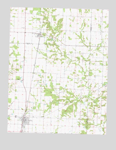
Tamaroa, IL USGS Topographic Map
Click on map above to begin viewing in our Map Viewer.

This topographic map contains these locations and features:
Feature Name Type Latitude Longitude GNIS ID View Map
Antioch CemeteryCemeteryN38.1414°W89.2498°403549View Map
Ashley Fire Protection District SubstationBuildingN38.2245°W89.2165°2640841View Map
Bald Hill CreekStreamN38.1573°W89.1390°403847View Map
Bald Hill School (historical)SchoolN38.1903°W89.1309°1705729View Map
Bethany Church (historical)ChurchN38.1684°W89.2090°1705746View Map
Big Ben MineMineN38.1567°W89.2237°1705747View Map
Chapel Hill CemeteryCemeteryN38.2295°W89.2312°405960View Map
Chapel Hill School (historical)SchoolN38.2292°W89.2304°1705765View Map
Collier CreekStreamN38.1620°W89.1476°406374View Map
Curlee CemeteryCemeteryN38.1781°W89.2362°406900View Map
Currie School (historical)SchoolN38.2278°W89.1701°1705766View Map
Du BoisPopulated PlaceN38.2239°W89.2123°407440View Map
Du Bois Post OfficePost OfficeN38.2239°W89.2121°2788654View Map
Eastland School (historical)SchoolN38.1395°W89.1584°1705748View Map
Eaton CreekStreamN38.1595°W89.1809°407723View Map
Hickory Knoll School (historical)SchoolN38.2001°W89.2312°1705753View Map
Hopewell School (historical)SchoolN38.1959°W89.2026°1705754View Map
Hurricane CreekStreamN38.1289°W89.1292°410714View Map
Lone Oak School (historical)SchoolN38.2314°W89.1331°1705735View Map
Puncheon CreekStreamN38.1859°W89.1534°416289View Map
Redbrush School (historical)SchoolN38.1806°W89.1665°1705759View Map
Rock BridgeBridgeN38.1339°W89.1370°1705740View Map
Saint Charles CemeteryCemeteryN38.2203°W89.1987°417235View Map
Scheller LakesLakeN38.1759°W89.1267°418077View Map
School Number 211SchoolN38.1770°W89.2323°425459View Map
TamaroaPopulated PlaceN38.1378°W89.2301°419532View Map
Tamaroa CemeteryCemeteryN38.1464°W89.2251°2042784View Map
Tamaroa Community Fire Protection DistrictBuildingN38.1403°W89.2308°2640430View Map
Tamaroa Elementary SchoolSchoolN38.1384°W89.2317°1808854View Map
Tamaroa Number 1 Election PrecinctCivilN38.1424°W89.1822°1928656View Map
Tamaroa Oil FieldOilfieldN38.1695°W89.1773°425546View Map
Tamaroa Post OfficePost OfficeN38.1381°W89.2290°2788494View Map
Turkey Trail CreekStreamN38.2045°W89.1479°419941View Map
Village of Du BoisCivilN38.2214°W89.2129°2398750View Map
Village of TamaroaCivilN38.1363°W89.2293°2399950View Map
West Lynn School (historical)SchoolN38.1406°W89.1815°1705761View Map

Note: Coordinates in the location and feature list above are referenced to NAD83 datum.


Copyright (C) 2008-2024 Ryan Niemi / Sunset Dynamics ... All Rights Reserved