TopoQuest Logo
Do you find TopoQuest useful?
Help keep TopoQuest running and adding new maps/features by donating!
Bitcoin:  19c7KJd3qBynnjoSw5npx9KScwjBe4ifkT
Litecoin:  LXs6TkuXGGXo1vDsWCkWVdjQX94eUKd6ui
Home View Maps Find Maps Find Places Resources & Links


Bloomington, Texas Topographic Map

USGS Map Title: Bloomington, TX
USGS Map MRC: 28096F8
DRG (GeoTIFF) Download: o28096f8.tif


Neighboring USGS Topographic Map Quads:


  Victoria West, TX  
28097G1
 

  Victoria East, TX  
28096G8
 

  Marcado Creek, TX  
28096G7
 

  Raisin, TX  
28097F1
 

  Bloomington, TX  
28096F8
 

  Placedo, TX  
28096F7
 

  McFaddin, TX  
28097E1
 

  Bloomington SW, TX  
28096E8
 

  Green Lake, TX  
28096E7


Map MRC Location:

N29°
W97°
N29°
W96°
H8 H7 H6 H5 H4 H3 H2 H1
G8 G7 G6 G5 G4 G3 G2 G1
F8 F7 F6 F5 F4 F3 F2 F1
E8 E7 E6 E5 E4 E3 E2 E1
D8 D7 D6 D5 D4 D3 D2 D1
C8 C7 C6 C5 C4 C3 C2 C1
B8 B7 B6 B5 B4 B3 B2 B1
A8 A7 A6 A5 A4 A3 A2 A1
N28°
W97°
N28°
W96°

Bloomington, TX USGS 1:24K Topographic Map Preview:
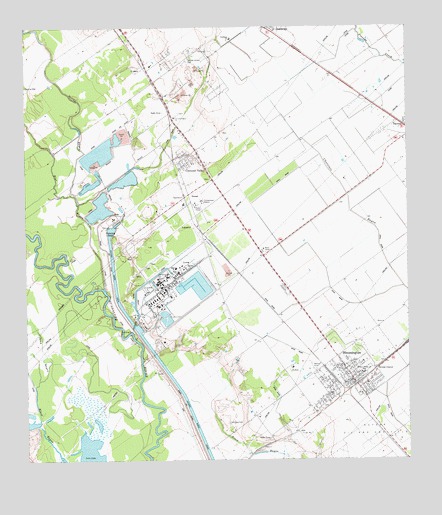
Bloomington, TX USGS Topographic Map
Click on map above to begin viewing in our Map Viewer.

This topographic map contains these locations and features:
Feature Name Type Latitude Longitude GNIS ID View Map
BloomingtonPopulated PlaceN28.6478°W96.8925°1352429View Map
Bloomington Census Designated PlaceCensusN28.6504°W96.9022°2407864View Map
Bloomington Elementary SchoolSchoolN28.6472°W96.8887°2008996View Map
Bloomington Post OfficePost OfficeN28.6484°W96.8925°2731409View Map
Bloomington Volunteer Fire Department Edward E Kocian StationBuildingN28.6475°W96.8939°2334646View Map
Blue BayouStreamN28.6744°W96.9744°1372633View Map
Crescent Valley ChurchChurchN28.7242°W96.9511°1355352View Map
Dalton BridgeBridgeN28.6586°W96.9625°1355556View Map
DernalPopulated PlaceN28.6955°W96.9444°1379656View Map
Dupont Cooling BasinReservoirN28.6655°W96.9534°1862463View Map
Dupont Cooling Basin DamDamN28.6669°W96.9519°1862462View Map
Guadalupe Elementary SchoolSchoolN28.7466°W96.9327°2009003View Map
Lipscomb and Son LeveeDamN28.6819°W96.9853°1862460View Map
Lipscomb and Son ReservoirReservoirN28.6832°W96.9851°1862461View Map
Pickering BasinBasinN28.6919°W96.9730°1377249View Map
Rupley LakeLakeN28.7344°W96.9892°1367015View Map
San Jose CemeteryCemeteryN28.6356°W96.9347°1367511View Map
Spring BayouStreamN28.6997°W96.9830°1368921View Map

Note: Coordinates in the location and feature list above are referenced to NAD83 datum.


Copyright (C) 2008-2024 Ryan Niemi / Sunset Dynamics ... All Rights Reserved