TopoQuest Logo
Do you find TopoQuest useful?
Help keep TopoQuest running and adding new maps/features by donating!
Bitcoin:  19c7KJd3qBynnjoSw5npx9KScwjBe4ifkT
Litecoin:  LXs6TkuXGGXo1vDsWCkWVdjQX94eUKd6ui
Home View Maps Find Maps Find Places Resources & Links


Thousand Island Park, New York Topographic Map

USGS Map Title: Thousand Island Park, NY
USGS Map MRC: 44076C1
DRG (GeoTIFF) Download: o44076c1.tif


Neighboring USGS Topographic Map Quads:


  Gananoque, ON  
44076C2
 

  Thousand Island Park, NY  
44076C1
 

  Alexandria Bay, NY  
44075C8
 

  Saint Lawrence, NY  
44076B2
 

  Clayton, NY  
44076B1
 

  La Fargeville, NY  
44075B8


Map MRC Location:

N45°
W77°
N45°
W76°
H8 H7 H6 H5 H4 H3 H2 H1
G8 G7 G6 G5 G4 G3 G2 G1
F8 F7 F6 F5 F4 F3 F2 F1
E8 E7 E6 E5 E4 E3 E2 E1
D8 D7 D6 D5 D4 D3 D2 D1
C8 C7 C6 C5 C4 C3 C2 C1
B8 B7 B6 B5 B4 B3 B2 B1
A8 A7 A6 A5 A4 A3 A2 A1
N44°
W77°
N44°
W76°

Thousand Island Park, NY USGS 1:24K Topographic Map Preview:
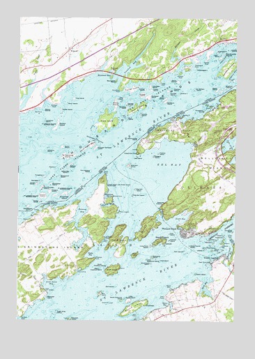
Thousand Island Park, NY USGS Topographic Map
Click on map above to begin viewing in our Map Viewer.

This topographic map contains these locations and features:
Feature Name Type Latitude Longitude GNIS ID View Map
Aunt Janes BayBayN44.2652°W76.1059°942701View Map
Basswood IslandIslandN44.2764°W76.0483°973337View Map
Big Gull IslandIslandN44.3042°W76.0580°943889View Map
Bill and Jacks MarinaLocaleN44.2750°W76.0038°973753View Map
Blind BaySwampN44.2667°W76.0163°944250View Map
Bluff IslandIslandN44.2709°W76.0705°944347View Map
Boscobel IslandIslandN44.2598°W76.1080°944467View Map
Bradley PointCapeN44.3348°W76.0297°944583View Map
Calumet IslandIslandN44.2500°W76.0955°945479View Map
Canoe PointCapeN44.3112°W76.0747°945787View Map
Canoe Point and Picnic Point State ParkParkN44.3062°W76.0747°945788View Map
Castle Francis IslandIslandN44.2812°W76.0261°945989View Map
Cedar IslandIslandN44.2837°W76.0108°946117View Map
Chapman ShoalBarN44.2575°W76.0726°973316View Map
Chapman Shoal LighthouseLocaleN44.2575°W76.0717°2353089View Map
Crow IslandIslandN44.3384°W76.0150°947844View Map
Delaney BayBayN44.2943°W76.0893°948256View Map
Eagle Wing GroupIslandN44.2528°W76.1024°948945View Map
Eel BayBayN44.3084°W76.0497°949414View Map
FineviewPopulated PlaceN44.2875°W76.0122°950065View Map
Fishers LandingPopulated PlaceN44.2764°W76.0080°972473View Map
Fishers Landing Census Designated PlaceCensusN44.2743°W76.0030°2584255View Map
Fishers Landing Fire DepartmentBuildingN44.2758°W76.0038°2718451View Map
Fishers Landing LightLocaleN44.2786°W76.0103°2353090View Map
Fishers Landing Post OfficePost OfficeN44.2761°W76.0088°2617919View Map
Flatiron IslandIslandN44.3195°W76.0447°950258View Map
Frederick IslandIslandN44.2850°W76.0066°950649View Map
FrontenacPopulated PlaceN44.2570°W76.0497°950756View Map
Grandview ParkPopulated PlaceN44.3195°W76.0552°951491View Map
Granite State Shoal LightLocaleN44.2836°W76.0158°2353091View Map
Grass PointCapeN44.2848°W76.0033°951543View Map
GrenellPopulated PlaceN44.2834°W76.0441°951806View Map
Grenell IslandIslandN44.2834°W76.0441°951807View Map
Grindstone IslandIslandN44.2750°W76.1163°951832View Map
Grossman PointCapeN44.2764°W76.0802°951847View Map
Gull IslandIslandN44.2639°W76.0688°951931View Map
Hub IslandIslandN44.2862°W76.0377°953348View Map
Irwin PointCapeN44.2598°W76.0399°953804View Map
Isle of PinesIslandN44.2795°W76.0133°974680View Map
Lasalle IslandIslandN44.2795°W76.0177°973751View Map
Lees IslandIslandN44.3178°W76.0569°955173View Map
Little Basswood IslandIslandN44.2753°W76.0508°955449View Map
Little Gull IslandIslandN44.3020°W76.0597°955547View Map
Little Round IslandIslandN44.2587°W76.0605°955667View Map
Long Rock IslandIslandN44.2809°W76.0488°955932View Map
Lower Town LandingPopulated PlaceN44.2700°W76.0911°972745View Map
Mandolin IslandIslandN44.2825°W76.0127°956339View Map
Maple IslandIslandN44.2770°W76.0577°956430View Map
Mason PointCapeN44.2637°W76.0369°956640View Map
Minna Anthony Common Nature CenterBuildingN44.3063°W76.0334°2617509View Map
Moore Dock Post LightBuildingN44.3167°W76.0014°2678393View Map
Mosquito IslandIslandN44.2987°W76.0455°957750View Map
Mullet CreekStreamN44.2764°W76.0047°958149View Map
Mullet Creek BayBayN44.2789°W76.0031°958150View Map
Murdoch PointCapeN44.2514°W76.1227°958176View Map
Murray IsleIslandN44.2900°W76.0505°958200View Map
Niagra ShoalBarN44.2870°W76.0058°973754View Map
North Colborne IslandIslandN44.2587°W76.0641°958751View Map
North Crawford IslandIslandN44.2725°W76.0738°958762View Map
Orient IslandIslandN44.2823°W76.0080°959474View Map
Picnic PointCapeN44.3014°W76.0699°960344View Map
Picton IslandIslandN44.2834°W76.0666°960349View Map
Pine IslandIslandN44.2614°W76.0772°943480View Map
Plumtree MarshSwampN44.2984°W76.0730°960781View Map
Point AngiersCapeN44.2953°W76.0663°960808View Map
Pullman IslandIslandN44.2834°W76.0377°961952View Map
Rainbow Shores Mobile Home ParkPopulated PlaceN44.2601°W76.0361°2618273View Map
Reed PointCapeN44.2742°W76.0161°962349View Map
Robinson GroupIslandN44.3142°W76.0619°962666View Map
Rock IslandIslandN44.2803°W76.0166°979978View Map
Rock Island ReefBarN44.2800°W76.0186°973752View Map
Round IslandIslandN44.2559°W76.0580°962971View Map
Rusho BayBayN44.2777°W76.0833°963106View Map
Rylstone IsleIslandN44.2812°W76.0080°971513View Map
Sargent IslandIslandN44.3181°W76.0475°964493View Map
School Number 1 (historical)SchoolN44.2861°W76.0981°2353092View Map
School Number 8 (historical)SchoolN44.3236°W76.0178°2353093View Map
Shady Bay Mobile Home ParkPopulated PlaceN44.2755°W76.0022°2618287View Map
Smugglers IslandIslandN44.3370°W76.0188°973748View Map
South BayBayN44.2931°W76.0307°965672View Map
Spicer BayBayN44.2572°W76.0389°966003View Map
Spicer Bay MarinaLocaleN44.2573°W76.0352°973750View Map
Spicer Bay School (historical)SchoolN44.2575°W76.0389°2353094View Map
Spicer Marine BasinHarborN44.2564°W76.0369°973747View Map
Susan IslandIslandN44.2856°W76.0066°966862View Map
Swiftwater PointCapeN44.2842°W76.0749°966937View Map
The NarrowsChannelN44.2950°W76.0424°974264View Map
Thousand Island ParkPopulated PlaceN44.2870°W76.0277°967447View Map
Thousand Island Park Census Designated PlaceCensusN44.2886°W76.0257°2584294View Map
Thousand Island Park MarinaLocaleN44.2850°W76.0266°973738View Map
Tidd IslandIslandN44.2750°W76.0427°967512View Map
Twin IslandIslandN44.2789°W76.0297°968038View Map
Upper Town LandingPopulated PlaceN44.2617°W76.1086°973182View Map
Vanderbilt IslandIslandN44.2873°W76.0013°968451View Map
Watch IslandIslandN44.2695°W76.0227°968886View Map
Waterson Point ParkParkN44.3387°W76.0072°968913View Map
Wellesley IslandIslandN44.3156°W76.0119°972133View Map
Wellesley Island State ParkParkN44.3292°W76.0238°969033View Map
Wellesley Island State Park Golf CourseLocaleN44.2898°W76.0165°2615090View Map
West Crawford IslandIslandN44.2714°W76.0780°969190View Map
Whitehouse MarshSwampN44.3017°W76.0747°971151View Map
Winter IslandIslandN44.2795°W76.0177°974172View Map
Woronoco IslandIslandN44.2737°W76.0486°971744View Map

Note: Coordinates in the location and feature list above are referenced to NAD83 datum.


Copyright (C) 2008-2024 Ryan Niemi / Sunset Dynamics ... All Rights Reserved