TopoQuest Logo
Do you find TopoQuest useful?
Help keep TopoQuest running and adding new maps/features by donating!
Bitcoin:  19c7KJd3qBynnjoSw5npx9KScwjBe4ifkT
Litecoin:  LXs6TkuXGGXo1vDsWCkWVdjQX94eUKd6ui
Home View Maps Find Maps Find Places Resources & Links


Transylvania, Louisiana Topographic Map

USGS Map Title: Transylvania, LA
USGS Map MRC: 32091F2
DRG (GeoTIFF) Download: o32091f2.tif


Neighboring USGS Topographic Map Quads:


  Baxter Bayou, LA  
32091G3
 

  Lake Providence, LA  
32091G2
 

  Whiting Bayou, MS  
32091G1
 

  Caraway Lake, LA  
32091F3
 

  Transylvania, LA  
32091F2
 

  Fitler, MS  
32091F1
 

  Panther Lake, LA  
32091E3
 

  Sondheimer, LA  
32091E2
 

  Eagle Bend, MS  
32091E1


Map MRC Location:

N33°
W92°
N33°
W91°
H8 H7 H6 H5 H4 H3 H2 H1
G8 G7 G6 G5 G4 G3 G2 G1
F8 F7 F6 F5 F4 F3 F2 F1
E8 E7 E6 E5 E4 E3 E2 E1
D8 D7 D6 D5 D4 D3 D2 D1
C8 C7 C6 C5 C4 C3 C2 C1
B8 B7 B6 B5 B4 B3 B2 B1
A8 A7 A6 A5 A4 A3 A2 A1
N32°
W92°
N32°
W91°

Transylvania, LA USGS 1:24K Topographic Map Preview:
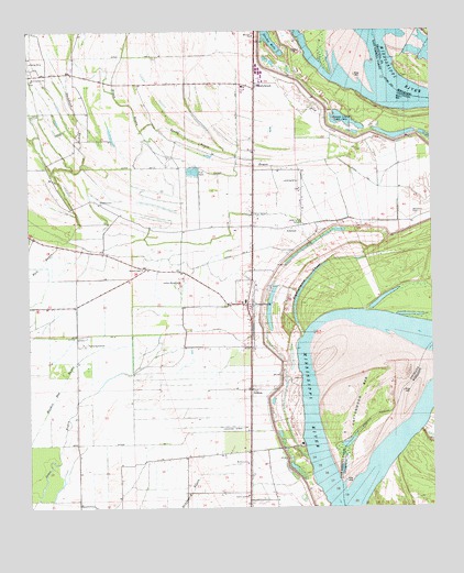
Transylvania, LA USGS Topographic Map
Click on map above to begin viewing in our Map Viewer.

This topographic map contains these locations and features:
Feature Name Type Latitude Longitude GNIS ID View Map
Alsatia-Salem BendBendN32.6285°W91.1537°549552View Map
Arcadia (historical)Populated PlaceN32.6487°W91.1257°687578View Map
Arcadia LandingLocaleN32.6487°W91.1262°711142View Map
Arcadia PointCapeN32.6493°W91.1259°711143View Map
AthertonPopulated PlaceN32.6985°W91.1704°542940View Map
Atherton TowheadBarN32.6793°W91.1501°548842View Map
Batton Airstrip (historical)AirportN32.6890°W91.2223°1632969View Map
Benjamin CemeteryCemeteryN32.7023°W91.1309°532937View Map
Boggy BayouStreamN32.7146°W91.2073°533285View Map
Church of ChristChurchN32.6285°W91.1829°548849View Map
Cold Tar CemeteryCemeteryN32.7001°W91.1659°534030View Map
Cottonwood BarBarN32.6551°W91.1476°534162View Map
Cottonwood BarIslandN32.6560°W91.1473°668854View Map
Ditch Number EightCanalN32.6910°W91.1859°534535View Map
Ditch Number FourCanalN32.7310°W91.1851°534534View Map
Ditch Number NineCanalN32.6707°W91.2304°534536View Map
Ditch Number OneCanalN32.7143°W91.2237°534532View Map
Duckpond BayouGutN32.7271°W91.2346°554291View Map
East Carroll ParishCivilN32.7326°W91.2351°558534View Map
Goodrich Post LightBuildingN32.6335°W91.1501°540687View Map
GrimesPopulated PlaceN32.6560°W91.1818°535426View Map
HollybrookPopulated PlaceN32.7351°W91.1798°535735View Map
Hollybrook CrevasseBasinN32.7276°W91.1529°554738View Map
Melbourne ChurchChurchN32.6371°W91.1826°537026View Map
Melbourne PlantationLocaleN32.6285°W91.1746°1630862View Map
Melville Plantation (historical)LocaleN32.6296°W91.1557°1630863View Map
Morningstar ChurchChurchN32.7374°W91.2484°537231View Map
Mound ChapelChurchN32.6876°W91.2148°537278View Map
Mount Zion ChurchChurchN32.7485°W91.1804°537453View Map
Otter BayouGutN32.7149°W91.1834°537905View Map
Parish Governing Authority District 2CivilN32.6999°W91.2373°1929890View Map
Pleasant Green ChurchChurchN32.7049°W91.2284°538238View Map
Sandy BayouGutN32.7221°W91.2001°539151View Map
Stump HoleLakeN32.7499°W91.1745°539700View Map
TransylvaniaPopulated PlaceN32.6785°W91.1826°543732View Map
Transylvania ChuteGutN32.6901°W91.1473°539976View Map
Transylvania Elementary School (historical)SchoolN32.6791°W91.1828°548878View Map
Transylvania Post Office (historical)Post OfficeN32.6774°W91.1826°1630873View Map
Ward TwoCivilN32.6790°W91.2112°545007View Map
WilmanPopulated PlaceN32.7326°W91.1612°548883View Map

Note: Coordinates in the location and feature list above are referenced to NAD83 datum.


Copyright (C) 2008-2024 Ryan Niemi / Sunset Dynamics ... All Rights Reserved