TopoQuest Logo
Do you find TopoQuest useful?
Help keep TopoQuest running and adding new maps/features by donating!
Bitcoin:  19c7KJd3qBynnjoSw5npx9KScwjBe4ifkT
Litecoin:  LXs6TkuXGGXo1vDsWCkWVdjQX94eUKd6ui
Home View Maps Find Maps Find Places Resources & Links


Trenton, Georgia Topographic Map

USGS Map Title: Trenton, GA
USGS Map MRC: 34085G5
DRG (GeoTIFF) Download: o34085g5.tif


Neighboring USGS Topographic Map Quads:


  Bridgeport, AL  
34085H6
 

  New Home, GA  
34085H5
 

  Hooker, GA  
34085H4
 

  Flat Rock, AL  
34085G6
 

  Trenton, GA  
34085G5
 

  Durham, GA  
34085G4
 

  Ider, AL  
34085F6
 

  Sulphur Springs, AL  
34085F5
 

  Cedar Grove, GA  
34085F4


Map MRC Location:

N35°
W86°
N35°
W85°
H8 H7 H6 H5 H4 H3 H2 H1
G8 G7 G6 G5 G4 G3 G2 G1
F8 F7 F6 F5 F4 F3 F2 F1
E8 E7 E6 E5 E4 E3 E2 E1
D8 D7 D6 D5 D4 D3 D2 D1
C8 C7 C6 C5 C4 C3 C2 C1
B8 B7 B6 B5 B4 B3 B2 B1
A8 A7 A6 A5 A4 A3 A2 A1
N34°
W86°
N34°
W85°

Trenton, GA USGS 1:24K Topographic Map Preview:
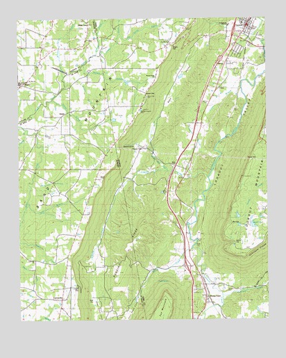
Trenton, GA USGS Topographic Map
Click on map above to begin viewing in our Map Viewer.

This topographic map contains these locations and features:
Feature Name Type Latitude Longitude GNIS ID View Map
Advent ChurchChurchN34.8673°W85.5905°139086View Map
Allison CreekStreamN34.7795°W85.5383°150067View Map
Austin CreekStreamN34.7904°W85.6241°150078View Map
Back ValleyStreamN34.8681°W85.5225°310701View Map
Bee GapGapN34.7898°W85.5177°311020View Map
BeulahPopulated PlaceN34.7592°W85.6141°155573View Map
Big Spring BranchStreamN34.8687°W85.5733°354244View Map
Brown GapGapN34.8437°W85.5602°334374View Map
Brown Gap CemeteryCemeteryN34.8426°W85.5600°334375View Map
Brown Gap ChurchChurchN34.8429°W85.5600°311867View Map
Brown Gap School (historical)SchoolN34.8429°W85.5614°334376View Map
Bullard BranchStreamN34.8558°W85.5919°150133View Map
Byrds ChapelChurchN34.8142°W85.5466°312134View Map
Cagle CemeteryCemeteryN34.7720°W85.5889°150137View Map
Cagle GapGapN34.7637°W85.5958°150138View Map
CartersvillePopulated PlaceN34.7584°W85.6041°163221View Map
Cartersville Volunteer Fire DepartmentBuildingN34.7575°W85.6046°2683161View Map
Cedar HillPopulated PlaceN34.8126°W85.5408°334378View Map
Church of ChristChurchN34.7540°W85.5333°334379View Map
Church of ChristChurchN34.8715°W85.5091°347464View Map
City of TrentonCivilN34.8741°W85.5096°2405603View Map
Clearview ChurchChurchN34.8131°W85.6241°158271View Map
Company CemeteryCemeteryN34.7626°W85.5200°312876View Map
Countess CemeteryCemeteryN34.8259°W85.6083°150171View Map
Crawfish CreekStreamN34.8087°W85.5300°150175View Map
Crooked BranchStreamN34.8281°W85.6216°150176View Map
Dade CountyCivilN34.8545°W85.5045°347465View Map
Dade County CourthouseBuildingN34.8723°W85.5094°347466View Map
Dade County Emergency Medical Station 5BuildingN34.8635°W85.5165°2625458View Map
Dade County High SchoolSchoolN34.8598°W85.5072°2545641View Map
Dade County JailBuildingN34.8727°W85.5105°2734216View Map
Dade County Sheriff's OfficeBuildingN34.8725°W85.5106°2733637View Map
Dade Elementary SchoolSchoolN34.8738°W85.5120°334380View Map
Dade Middle SchoolSchoolN34.8723°W85.5184°334381View Map
Dade Primary SchoolSchoolN34.8739°W85.5121°2545640View Map
Daniel CemeteryCemeteryN34.8684°W85.5308°313281View Map
Deer Head ChurchChurchN34.7684°W85.5822°158814View Map
Deer Head CoveValleyN34.7699°W85.5594°150194View Map
Deer Head CovePopulated PlaceN34.7726°W85.5827°158274View Map
Deer Head School (historical)SchoolN34.7684°W85.5819°157520View Map
Duncan CreekStreamN34.8603°W85.5856°150209View Map
Easley CemeteryCemeteryN34.7806°W85.5344°313762View Map
Easley GapGapN34.7820°W85.5166°313763View Map
East Brow ChurchChurchN34.8129°W85.5847°158275View Map
Edgewood Missionary Baptist ChurchChurchN34.8562°W85.5211°347467View Map
ElizaPopulated PlaceN34.8640°W85.6130°139157View Map
Exit OneCrossingN34.7720°W85.5408°347468View Map
Exit TwoCrossingN34.8695°W85.5161°347469View Map
First Baptist Church of TrentonChurchN34.8712°W85.5089°334382View Map
Floral CrestPopulated PlaceN34.8737°W85.5902°118441View Map
Forest Hill ChurchChurchN34.7745°W85.6175°150077View Map
GassPopulated PlaceN34.8637°W85.5491°331796View Map
Hanna CemeteryCemeteryN34.7520°W85.5338°315090View Map
Harris ChapelChurchN34.8679°W85.5822°334384View Map
Harris CreekStreamN34.8687°W85.5733°354247View Map
Haynes ChapelChurchN34.8087°W85.5844°150448View Map
HigdonPopulated PlaceN34.8456°W85.6164°120045View Map
Higdon Post OfficePost OfficeN34.8481°W85.6221°2788953View Map
Hurricane CreekStreamN34.7601°W85.5230°315854View Map
Life and Praise TempleChurchN34.8173°W85.5825°159000View Map
Long CemeteryCemeteryN34.8106°W85.5394°317345View Map
Magby GapGapN34.8634°W85.5461°356376View Map
McGee LakeReservoirN34.7891°W85.5073°337105View Map
McGee Lake DamDamN34.7901°W85.5083°337104View Map
Moore LakeReservoirN34.7898°W85.5083°334388View Map
Mount OlivePopulated PlaceN34.8479°W85.6233°150399View Map
Mount Olive ChurchChurchN34.8492°W85.6200°139224View Map
New Testament ChurchChurchN34.8092°W85.5855°158290View Map
Newman CemeteryCemeteryN34.8406°W85.5302°319573View Map
North Sand Mountain High SchoolSchoolN34.8487°W85.6244°139237View Map
Northwest Georgia High SchoolSchoolN34.8723°W85.5189°334394View Map
Payne CemeteryCemeteryN34.8084°W85.5827°157533View Map
Payne GapGapN34.8170°W85.5058°320298View Map
Pleasant Grove ChurchChurchN34.8506°W85.5558°334395View Map
Poplar SpringSpringN34.7662°W85.5494°321030View Map
Pudding RidgeRidgeN34.7832°W85.5666°150472View Map
Rising FawnPopulated PlaceN34.7601°W85.5311°332861View Map
Rising Fawn Baptist ChurchChurchN34.7631°W85.5319°334397View Map
Rising Fawn ChurchChurchN34.7579°W85.5314°352012View Map
Rising Fawn Church of GodChurchN34.7676°W85.5336°347471View Map
Rising Fawn Post OfficePost OfficeN34.7595°W85.5311°352013View Map
Rocky Ford BranchStreamN34.8084°W85.6183°150490View Map
Sally BranchStreamN34.7984°W85.6202°150500View Map
Sand Mountain Academy (historical)SchoolN34.8737°W85.5886°139275View Map
Sand Mountain ChurchChurchN34.8651°W85.5483°334399View Map
Sandmont Bible CampLocaleN34.8459°W85.5683°352014View Map
ShilohPopulated PlaceN34.8351°W85.6033°157052View Map
Shiloh ChurchChurchN34.8345°W85.6027°150742View Map
Shiloh CreekStreamN34.8415°W85.6083°150510View Map
South Dade Fire DepartmentBuildingN34.7620°W85.5366°2604393View Map
Stewart GulchValleyN34.8227°W85.5654°323604View Map
Stewart TownPopulated PlaceN34.8212°W85.5630°333128View Map
Stewart Town CreekStreamN34.8120°W85.5500°323607View Map
Tadpole BranchStreamN34.8176°W85.5239°323884View Map
Tatum (historical)Populated PlaceN34.8381°W85.5155°334401View Map
TrentonPopulated PlaceN34.8720°W85.5091°333261View Map
Trenton Post OfficePost OfficeN34.8732°W85.5092°352017View Map
Trenton United Methodist ChurchChurchN34.8734°W85.5083°347472View Map
Turner BranchStreamN34.8465°W85.5127°324402View Map
UnionPopulated PlaceN34.8451°W85.5250°333302View Map
United Church of ChristChurchN34.8704°W85.5066°347473View Map
Vaught LakeReservoirN34.8489°W85.5700°339710View Map
Vaught Lake DamDamN34.8501°W85.5716°339709View Map
Well FlatLakeN34.7578°W85.5869°150581View Map
White Oak MineMineN34.8745°W85.5352°352018View Map
Williams Spring BranchStreamN34.8506°W85.6033°153999View Map
Wooden BranchStreamN34.8526°W85.5991°129190View Map
Wooten BranchStreamN34.8522°W85.5981°2786092View Map
Young LakeReservoirN34.8510°W85.5428°339708View Map
Young Lake DamDamN34.8517°W85.5416°339707View Map

Note: Coordinates in the location and feature list above are referenced to NAD83 datum.


Copyright (C) 2008-2024 Ryan Niemi / Sunset Dynamics ... All Rights Reserved