TopoQuest Logo
Do you find TopoQuest useful?
Help keep TopoQuest running and adding new maps/features by donating!
Bitcoin:  19c7KJd3qBynnjoSw5npx9KScwjBe4ifkT
Litecoin:  LXs6TkuXGGXo1vDsWCkWVdjQX94eUKd6ui
Home View Maps Find Maps Find Places Resources & Links


Unicoi, Tennessee Topographic Map

USGS Map Title: Unicoi, TN
USGS Map MRC: 36082B3
DRG (GeoTIFF) Download: o36082b3.tif


Neighboring USGS Topographic Map Quads:


  Jonesborough, TN  
36082C4
 

  Johnson City, TN  
36082C3
 

  Elizabethton, TN  
36082C2
 

  Erwin, TN  
36082B4
 

  Unicoi, TN  
36082B3
 

  Iron Mountain Gap, TN  
36082B2
 

  Chestoa, TN  
36082A4
 

  Huntdale, NC  
36082A3
 

  Bakersville, NC  
36082A2


Map MRC Location:

N37°
W83°
N37°
W82°
H8 H7 H6 H5 H4 H3 H2 H1
G8 G7 G6 G5 G4 G3 G2 G1
F8 F7 F6 F5 F4 F3 F2 F1
E8 E7 E6 E5 E4 E3 E2 E1
D8 D7 D6 D5 D4 D3 D2 D1
C8 C7 C6 C5 C4 C3 C2 C1
B8 B7 B6 B5 B4 B3 B2 B1
A8 A7 A6 A5 A4 A3 A2 A1
N36°
W83°
N36°
W82°

Unicoi, TN USGS 1:24K Topographic Map Preview:
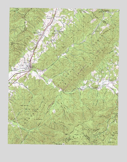
Unicoi, TN USGS Topographic Map
Click on map above to begin viewing in our Map Viewer.

This topographic map contains these locations and features:
Feature Name Type Latitude Longitude GNIS ID View Map
Appalachian Flying Service Number One Airport (historical)AirportN36.1773°W82.3332°1301404View Map
Bear Trail RidgeRidgeN36.1604°W82.3118°1276629View Map
Bell CemeteryCemeteryN36.1776°W82.2707°1641285View Map
Bell CemeteryCemeteryN36.1776°W82.2710°1276919View Map
Big BallSummitN36.1290°W82.2749°1004527View Map
Britt MineMineN36.2059°W82.3115°1642392View Map
Brummett HollowValleyN36.2059°W82.3134°1278665View Map
Buchanan CemeteryCemeteryN36.1773°W82.2504°1646951View Map
Buffalo High PointLocaleN36.2173°W82.3696°1641298View Map
Buffalo MountainRidgeN36.2176°W82.3704°1269399View Map
Carroll ChapelChurchN36.2293°W82.3193°1279745View Map
Carroll ChapelChurchN36.2287°W82.3196°1641309View Map
CCC Camp Cordell HullLocaleN36.1890°W82.3351°1641293View Map
Cherokee National Forest Fire ServiceBuildingN36.1934°W82.3458°2654905View Map
Cherry GapGapN36.1346°W82.2571°983077View Map
Cherry Gap ShelterLocaleN36.1326°W82.2624°1641274View Map
Clear ForkStreamN36.1490°W82.2610°1280672View Map
Commissioner District 3CivilN36.1875°W82.3074°2464203View Map
Cordwood BranchStreamN36.1821°W82.2676°1281299View Map
Cordwood BranchStreamN36.1821°W82.2679°1641282View Map
Cove BranchStreamN36.2140°W82.3057°1281401View Map
Cove BranchStreamN36.2137°W82.3060°1641307View Map
Dark HollowValleyN36.1700°W82.3468°1282048View Map
Dark HollowValleyN36.1696°W82.3446°1641261View Map
Davis SpringsPopulated PlaceN36.1771°W82.2757°1314936View Map
Davis SpringsSpringN36.1773°W82.2737°1641288View Map
Dick CreekStreamN36.1746°W82.3137°1641275View Map
Dick CreekStreamN36.1743°W82.3135°1282424View Map
Dick Creek GapGapN36.1479°W82.3357°1641263View Map
Dick Creek GapGapN36.1479°W82.3424°1282426View Map
Dry Creek Camp GroundLocaleN36.2484°W82.2699°1282948View Map
Dry Creek SchoolSchoolN36.1809°W82.3746°1641295View Map
Dry Creek SchoolSchoolN36.1812°W82.3743°1282953View Map
Fall BranchStreamN36.1507°W82.2624°1284059View Map
Fall BranchStreamN36.1504°W82.2610°1641276View Map
Gaddy ProspectMineN36.2223°W82.3199°1642406View Map
Grindstaff CemeteryCemeteryN36.1851°W82.2535°1641283View Map
Grindstaff CemeteryCemeteryN36.1857°W82.2535°1286305View Map
Head ProspectMineN36.2176°W82.3187°1642407View Map
Hemlock Forest TrailTrailN36.1371°W82.3515°1647936View Map
Honeycomb CreekStreamN36.2487°W82.2682°1288209View Map
Honeycomb CreekStreamN36.2482°W82.2685°1641312View Map
Honeycomb MountainSummitN36.2295°W82.2631°1288210View Map
Horseback RidgeRidgeN36.1446°W82.3087°1288415View Map
Indian CreekStreamN36.1629°W82.2524°1641329View Map
Irishman BranchStreamN36.1837°W82.3324°1289043View Map
Irishman BranchStreamN36.1840°W82.3332°1641292View Map
Ivy Hill ChurchChurchN36.2296°W82.2779°1641311View Map
Ivy Hill ChurchChurchN36.2298°W82.2776°1289127View Map
Jeffrey CreekStreamN36.2479°W82.2640°1289335View Map
Jeffrey CreekStreamN36.2476°W82.2637°1641313View Map
John Brummett MineMineN36.2154°W82.3026°1642410View Map
Jones ChapelChurchN36.1932°W82.3668°1289773View Map
Jones ChapelChurchN36.1929°W82.3674°1641294View Map
Jones MineMineN36.1771°W82.3682°1642411View Map
Laughren ChapelChurchN36.2273°W82.3404°1641305View Map
Laughren ChapelChurchN36.2279°W82.3399°1290682View Map
Limestone CovePopulated PlaceN36.1809°W82.2618°1315402View Map
Limestone Cove CampgroundLocaleN36.1773°W82.2960°1641287View Map
Limestone Cove Recreation AreaParkN36.1757°W82.2962°1647937View Map
Limestone Cove School (historical)SchoolN36.1812°W82.2612°1320116View Map
Limestone Cove TrailTrailN36.1654°W82.2924°1647938View Map
Limestone Cove Volunteer Fire DepartmentBuildingN36.1807°W82.2613°2654828View Map
Little Dark HollowValleyN36.1700°W82.3457°1291471View Map
Little Dark Hollow TrailTrailN36.1668°W82.3332°1647939View Map
Little MountainSummitN36.2423°W82.2790°1641310View Map
Little MountainRangeN36.2426°W82.2793°1641328View Map
Little Rocky BranchStreamN36.1771°W82.2743°1291652View Map
Long BranchStreamN36.1465°W82.3696°1291885View Map
Long BranchStreamN36.1462°W82.3701°1641258View Map
Low GapGapN36.1290°W82.2765°989078View Map
MarbletonLocaleN36.2409°W82.3265°1315464View Map
MarbletonPopulated PlaceN36.2404°W82.3276°1641303View Map
Marbleton SchoolSchoolN36.2268°W82.3193°1292670View Map
Marbleton SchoolSchoolN36.2265°W82.3199°1641304View Map
Nelson GapGapN36.1568°W82.3557°1295384View Map
Nelson High PointLocaleN36.1601°W82.3649°1641264View Map
Nelson High PointSummitN36.1604°W82.3607°1295385View Map
Oldfield BranchStreamN36.2093°W82.3110°1641308View Map
Oldfield BranchStreamN36.2093°W82.3104°1296398View Map
Paint BranchStreamN36.1776°W82.2732°1641289View Map
Paint BranchStreamN36.1779°W82.2726°1296657View Map
Peterson CemeteryCemeteryN36.1898°W82.3518°1297258View Map
Peterson CemeteryCemeteryN36.1893°W82.3518°1641297View Map
Piney BallSummitN36.1359°W82.2546°1021942View Map
Pinnacle MountainSummitN36.2173°W82.3701°1297680View Map
Pinnacle Mountain LookoutLocaleN36.2171°W82.3704°1641300View Map
Pinnacle Tower TrailTrailN36.2215°W82.3657°1647941View Map
Pleasant GardenPopulated PlaceN36.1340°W82.3107°1315729View Map
Rattlesnake RidgeRidgeN36.1390°W82.3190°1298950View Map
Rattlesnake RidgeRidgeN36.1440°W82.3304°1641267View Map
Rattlesnake RidgeRidgeN36.1623°W82.3326°1298951View Map
Rattlesnake Ridge TrailTrailN36.1546°W82.3310°1647942View Map
Rattlesnake TrailTrailN36.1557°W82.3290°1641269View Map
Ravens Lore TrailTrailN36.1337°W82.3087°1647943View Map
Red ForkStreamN36.1612°W82.2510°1299046View Map
Red ForkStreamN36.1607°W82.2510°1641280View Map
Red Fork Falls TrailTrailN36.1487°W82.2612°1647944View Map
Red Fork SchoolSchoolN36.1546°W82.2501°1299047View Map
Red Fork SchoolSchoolN36.1540°W82.2501°1641281View Map
Right Prong Rock CreekStreamN36.1379°W82.3529°1299440View Map
Right Prong Rock CreekStreamN36.1382°W82.3529°1641327View Map
Rock Creek Bicycle TrailTrailN36.1382°W82.3518°1647945View Map
Rock Creek Camp GroundLocaleN36.1371°W82.3524°1641268View Map
Rock Creek Camp GroundLocaleN36.1368°W82.3512°1299756View Map
Rock Creek Falls TrailTrailN36.1362°W82.3393°1647946View Map
Rocky BranchStreamN36.1768°W82.2954°1299864View Map
Rocky BranchStreamN36.1771°W82.2954°1641286View Map
Sam Brummett MineMineN36.2257°W82.2826°1642429View Map
Scioto CreekStreamN36.1946°W82.3485°1300909View Map
Scioto CreekStreamN36.1943°W82.3485°1641296View Map
Scoito Shooting RangeLocaleN36.1971°W82.3260°1641290View Map
ShadtownPopulated PlaceN36.2296°W82.3190°1315899View Map
Stamping Ground RidgeRidgeN36.1496°W82.2793°1271212View Map
Stamping Ground TrailTrailN36.1609°W82.2682°1647947View Map
Stone MountainSummitN36.2101°W82.2676°1303855View Map
Stone MountainRangeN36.2240°W82.2574°1641321View Map
Straight CreekStreamN36.1718°W82.3165°1271568View Map
Straight CreekStreamN36.1723°W82.3165°1641291View Map
Street MineMineN36.1987°W82.3465°1642432View Map
Sugar HollowValleyN36.2212°W82.3332°1646960View Map
Swingle CemeteryCemeteryN36.1970°W82.3612°1641259View Map
Swingle CemeteryCemeteryN36.1965°W82.3607°1271993View Map
Three MountainsPopulated PlaceN36.2473°W82.2637°1646887View Map
Three Mountains SchoolSchoolN36.2482°W82.2646°1272581View Map
Three Mountains SchoolsSchoolN36.2482°W82.2643°1641314View Map
Tipton ProspectMineN36.2376°W82.3090°1642433View Map
Town of UnicoiCivilN36.2217°W82.3290°2406775View Map
Turkey Trail BranchStreamN36.1651°W82.3212°1641270View Map
Turkey Trail BranchStreamN36.1654°W82.3210°1273034View Map
Unaka MountainSummitN36.1334°W82.2965°1304217View Map
Unaka Mountain CampgroundLocaleN36.1351°W82.3087°1641272View Map
Unaka Mountain Recreation AreaParkN36.1446°W82.2924°1647948View Map
Unaka Mountain Scenic AreaLocaleN36.1396°W82.3093°1641266View Map
Unaka Mountain Scenic TrailTrailN36.1434°W82.3026°1647949View Map
Unaka Mountain WildernessReserveN36.1435°W82.3045°2035330View Map
UnicoiPopulated PlaceN36.1954°W82.3496°1304219View Map
Unicoi Baptist ChurchChurchN36.1965°W82.3501°1320118View Map
Unicoi Division (historical)CensusN36.2032°W82.3249°1648988View Map
Unicoi Elementary SchoolSchoolN36.1965°W82.3537°1307950View Map
Unicoi MineMineN36.1848°W82.3460°1642437View Map
Unicoi Post OfficePost OfficeN36.1994°W82.3497°1649456View Map
Unicoi ProspectMineN36.2040°W82.3376°1642438View Map
Unicoi Volunteer Fire DepartmentBuildingN36.1973°W82.3494°2654863View Map
Whispering PinesPopulated PlaceN36.2482°W82.2876°1646963View Map

Note: Coordinates in the location and feature list above are referenced to NAD83 datum.


Copyright (C) 2008-2024 Ryan Niemi / Sunset Dynamics ... All Rights Reserved