TopoQuest Logo
Do you find TopoQuest useful?
Help keep TopoQuest running and adding new maps/features by donating!
Bitcoin:  19c7KJd3qBynnjoSw5npx9KScwjBe4ifkT
Litecoin:  LXs6TkuXGGXo1vDsWCkWVdjQX94eUKd6ui
Home View Maps Find Maps Find Places Resources & Links


Walstonburg, North Carolina Topographic Map

USGS Map Title: Walstonburg, NC
USGS Map MRC: 35077E6
DRG (GeoTIFF) Download: o35077e6.tif


Neighboring USGS Topographic Map Quads:


  Saratoga, NC  
35077F7
 

  Fountain, NC  
35077F6
 

  Falkland, NC  
35077F5
 

  Stantonsburg, NC  
35077E7
 

  Walstonburg, NC  
35077E6
 

  Farmville, NC  
35077E5
 

  Jason, NC  
35077D7
 

  Snow Hill, NC  
35077D6
 

  Hookerton, NC  
35077D5


Map MRC Location:

N36°
W78°
N36°
W77°
H8 H7 H6 H5 H4 H3 H2 H1
G8 G7 G6 G5 G4 G3 G2 G1
F8 F7 F6 F5 F4 F3 F2 F1
E8 E7 E6 E5 E4 E3 E2 E1
D8 D7 D6 D5 D4 D3 D2 D1
C8 C7 C6 C5 C4 C3 C2 C1
B8 B7 B6 B5 B4 B3 B2 B1
A8 A7 A6 A5 A4 A3 A2 A1
N35°
W78°
N35°
W77°

Walstonburg, NC USGS 1:24K Topographic Map Preview:
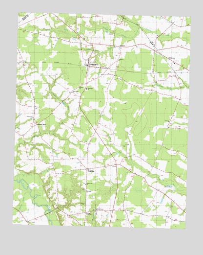
Walstonburg, NC USGS Topographic Map
Click on map above to begin viewing in our Map Viewer.

This topographic map contains these locations and features:
Feature Name Type Latitude Longitude GNIS ID View Map
AppiePopulated PlaceN35.5960°W77.7450°1003655View Map
CastoriaPopulated PlaceN35.5365°W77.6744°982739View Map
Castoria Fire Department and Emergency Medical ServicesBuildingN35.5356°W77.6756°2638296View Map
ContentneaPopulated PlaceN35.5018°W77.7308°1023922View Map
Daisy SidingPopulated PlaceN35.5918°W77.6500°1008119View Map
FieldsboroPopulated PlaceN35.6057°W77.6739°985067View Map
Fieldsboro Post Office (historical)Post OfficeN35.6063°W77.6747°1008120View Map
Fools BridgeBridgeN35.5063°W77.7250°985260View Map
Fort RunStreamN35.5002°W77.7219°985325View Map
Free Union ChurchChurchN35.5204°W77.6969°1003668View Map
Friendship ChurchChurchN35.5632°W77.6383°1003664View Map
Herrings CrossroadsPopulated PlaceN35.5085°W77.6972°1003669View Map
Holy Temple ChurchChurchN35.5874°W77.6733°1003658View Map
Howell SwampSwampN35.5546°W77.7225°1024049View Map
Howell Swamp ChurchChurchN35.5790°W77.7091°1003663View Map
Lighter Knot SwampStreamN35.6132°W77.6764°1003656View Map
Meadow ChurchChurchN35.5990°W77.6764°1003657View Map
Nahunta SwampStreamN35.5127°W77.7325°990843View Map
North Greene SchoolSchoolN35.5810°W77.6989°1003661View Map
Saint Delight ChurchChurchN35.5821°W77.7044°1003662View Map
Speights BridgePopulated PlaceN35.5590°W77.7353°995285View Map
Speights Bridge Post Office (historical)Post OfficeN35.5168°W77.7372°1008117View Map
Sunset Memorial ParkCemeteryN35.5993°W77.6405°1003659View Map
Tabernacle ChurchChurchN35.5638°W77.7372°1003660View Map
Tabernacle ChurchChurchN35.5635°W77.7455°1008118View Map
Thompson SwampStreamN35.6188°W77.6616°1024484View Map
Town of WalstonburgCivilN35.5961°W77.6980°2406829View Map
Township of CarrsCivilN35.5536°W77.6739°1026722View Map
Township of Speights BridgeCivilN35.5845°W77.7275°1026729View Map
WalstonburgPopulated PlaceN35.5946°W77.6969°1024485View Map
Walstonburg Post OfficePost OfficeN35.5949°W77.6979°2774041View Map
Walstonburg Rural Fire AssociationBuildingN35.5997°W77.6976°2638330View Map
Washington Branch ChurchChurchN35.5102°W77.6900°1024453View Map
Wootens CrossroadsPopulated PlaceN35.5338°W77.6969°1003666View Map
Zecharias Zion ChurchChurchN35.5252°W77.6975°1003667View Map

Note: Coordinates in the location and feature list above are referenced to NAD83 datum.


Copyright (C) 2008-2024 Ryan Niemi / Sunset Dynamics ... All Rights Reserved