TopoQuest Logo
Do you find TopoQuest useful?
Help keep TopoQuest running and adding new maps/features by donating!
Bitcoin:  19c7KJd3qBynnjoSw5npx9KScwjBe4ifkT
Litecoin:  LXs6TkuXGGXo1vDsWCkWVdjQX94eUKd6ui
Home View Maps Find Maps Find Places Resources & Links


Wilson, Arkansas Topographic Map

USGS Map Title: Wilson, AR
USGS Map MRC: 35090E1
DRG (GeoTIFF) Download: o35090e1.tif


Neighboring USGS Topographic Map Quads:


  Etowah, AR  
35090F2
 

  Keiser, AR  
35090F1
 

  Osceola, AR  
35089F8
 

  Joiner, AR  
35090E2
 

  Wilson, AR  
35090E1
 

  Nodena, AR  
35089E8
 

  Frenchmans Bayou, AR  
35090D2
 

  Pecan Point, AR  
35090D1
 

  Drummonds, TN  
35089D8


Map MRC Location:

N36°
W91°
N36°
W90°
H8 H7 H6 H5 H4 H3 H2 H1
G8 G7 G6 G5 G4 G3 G2 G1
F8 F7 F6 F5 F4 F3 F2 F1
E8 E7 E6 E5 E4 E3 E2 E1
D8 D7 D6 D5 D4 D3 D2 D1
C8 C7 C6 C5 C4 C3 C2 C1
B8 B7 B6 B5 B4 B3 B2 B1
A8 A7 A6 A5 A4 A3 A2 A1
N35°
W91°
N35°
W90°

Wilson, AR USGS 1:24K Topographic Map Preview:
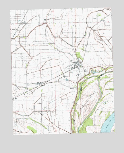
Wilson, AR USGS Topographic Map
Click on map above to begin viewing in our Map Viewer.

This topographic map contains these locations and features:
Feature Name Type Latitude Longitude GNIS ID View Map
Bend of island 35 RevetmentLeveeN35.5106°W90.0501°75267View Map
Bethlehem ChurchChurchN35.5159°W90.1109°76326View Map
Cedar Point Upper BarBarN35.5020°W90.0084°1310740View Map
City of WilsonCivilN35.5662°W90.0430°2405757View Map
Davis Church (historical)ChurchN35.5879°W90.0487°61975View Map
DelproPopulated PlaceN35.5523°W90.0845°57639View Map
Ditch ACanalN35.5504°W90.0826°48528View Map
Ditch ECanalN35.5362°W90.1095°48530View Map
Ditch Number 1CanalN35.5231°W90.0901°82020View Map
Ditch Number 19CanalN35.6240°W90.0062°82128View Map
Ditch Number 2CanalN35.5079°W90.0712°82137View Map
Ditch Number 21CanalN35.6181°W90.0062°61978View Map
Ditch Number 22CanalN35.5970°W90.0165°78827View Map
Ditch Number 23CanalN35.5917°W90.0201°61977View Map
Ditch Number 24CanalN35.5876°W90.0015°82176View Map
Ditch Number 24ACanalN35.6034°W90.0090°61980View Map
Ditch Number 3CanalN35.5340°W90.0712°82202View Map
Ditch Number 33CanalN35.5654°W90.0823°82222View Map
Ditch Number 34CanalN35.5737°W90.0779°61971View Map
Ditch Number 4CanalN35.5323°W90.0959°82247View Map
Ditch Number 9CanalN35.6006°W90.0443°76536View Map
DriverPopulated PlaceN35.6123°W90.0120°57678View Map
Driver Post OfficePost OfficeN35.6131°W90.0115°84038View Map
EvadalePopulated PlaceN35.5512°W90.1062°76887View Map
Evadale JunctionLocaleN35.5523°W90.0820°61969View Map
First Baptist Church of WilsonChurchN35.5712°W90.0420°61974View Map
Golden LakePopulated PlaceN35.5459°W90.0456°57832View Map
Golden Lake (historical)LakeN35.5229°W90.0812°61968View Map
Golden Lake CemeteryCemeteryN35.5473°W90.0465°49478View Map
Golden Lake ChurchChurchN35.5479°W90.0454°49479View Map
Golden Lake CrevasseBasinN35.5606°W90.0193°49480View Map
Golden Lake LandingLocaleN35.5467°W90.0412°70086View Map
Golden Lake RevetmentCanalN35.5387°W90.0426°79122View Map
Holt (historical)Populated PlaceN35.6187°W90.0006°61979View Map
Howards LandingLocaleN35.5098°W90.0101°1314266View Map
Interchange 41CrossingN35.6112°W90.1123°59068View Map
Island Number 35IslandN35.5184°W90.0137°1647752View Map
Island Number 35IslandN35.5184°W90.0137°1289096View Map
Lowrance Airport (historical)AirportN35.6126°W90.0209°83681View Map
Macedonia CemeteryCemeteryN35.5890°W90.0357°51551View Map
Macedonia ChurchChurchN35.5881°W90.0362°51580View Map
MariePopulated PlaceN35.6104°W90.0809°58124View Map
McFadden CemeteryCemeteryN35.5540°W90.0797°61970View Map
Mount Olive CemeteryCemeteryN35.5422°W90.1080°52333View Map
Mount Olive ChurchChurchN35.5429°W90.1059°52361View Map
New Mount Zion ChurchChurchN35.5492°W90.0887°52727View Map
Nodena Memorial Baptist ChurchChurchN35.5576°W90.0348°61976View Map
Pilgrims Rest ChurchChurchN35.5754°W90.0718°53391View Map
Pittman CemeteryCemeteryN35.6080°W90.0463°53511View Map
Pleasant Grove CemeteryCemeteryN35.6193°W90.0792°53531View Map
Pleasant Grove ChurchChurchN35.6192°W90.0793°53548View Map
Rivercrest High SchoolSchoolN35.6126°W90.1070°61967View Map
Rivercrest Junior HighSchoolN35.5653°W90.0515°61972View Map
Spur FourPopulated PlaceN35.6192°W90.0890°58675View Map
Towhead of Island Number Thirty-fiveIslandN35.5320°W90.0312°1272793View Map
Town of MarieCivilN35.6132°W90.0835°2406095View Map
Township of CarsonCivilN35.6092°W90.0158°2406944View Map
Township of Carson Lake (historical)CivilN35.6223°W90.0668°69654View Map
Township of Golden LakeCivilN35.5157°W90.0542°69659View Map
WilsonPopulated PlaceN35.5681°W90.0420°58899View Map
Wilson Elementary SchoolSchoolN35.5654°W90.0508°61973View Map
Wilson Landing Strip (historical)AirportN35.5676°W90.0540°66239View Map
Wilson LodgeLocaleN35.5537°W90.0365°56450View Map
Wilson Middle SchoolSchoolN35.5660°W90.0474°2121463View Map
Wilson Post OfficePost OfficeN35.5692°W90.0424°2773502View Map
Wilson SchoolSchoolN35.5737°W90.0518°56451View Map
Wilson Volunteer Fire DepartmentBuildingN35.5662°W90.0468°2117324View Map

Note: Coordinates in the location and feature list above are referenced to NAD83 datum.


Copyright (C) 2008-2024 Ryan Niemi / Sunset Dynamics ... All Rights Reserved