TopoQuest Logo
Do you find TopoQuest useful?
Help keep TopoQuest running and adding new maps/features by donating!
Bitcoin:  19c7KJd3qBynnjoSw5npx9KScwjBe4ifkT
Litecoin:  LXs6TkuXGGXo1vDsWCkWVdjQX94eUKd6ui
Home View Maps Find Maps Find Places Resources & Links


Winnisquam Lake, New Hampshire Topographic Map

USGS Map Title: Winnisquam Lake, NH
USGS Map MRC: 43071E5
DRG (GeoTIFF) Download: o43071e5.tif


Neighboring USGS Topographic Map Quads:


  Ashland, NH  
43071F6
 

  Holderness, NH  
43071F5
 

  Center Harbor, NH  
43071F4
 

  Bristol, NH  
43071E6
 

  Winnisquam Lake, NH  
43071E5
 

  Laconia, NH  
43071E4
 

  Franklin, NH  
43071D6
 

  Northfield, NH  
43071D5
 

  Belmont, NH  
43071D4


Map MRC Location:

N44°
W72°
N44°
W71°
H8 H7 H6 H5 H4 H3 H2 H1
G8 G7 G6 G5 G4 G3 G2 G1
F8 F7 F6 F5 F4 F3 F2 F1
E8 E7 E6 E5 E4 E3 E2 E1
D8 D7 D6 D5 D4 D3 D2 D1
C8 C7 C6 C5 C4 C3 C2 C1
B8 B7 B6 B5 B4 B3 B2 B1
A8 A7 A6 A5 A4 A3 A2 A1
N43°
W72°
N43°
W71°

Winnisquam Lake, NH USGS 1:24K Topographic Map Preview:
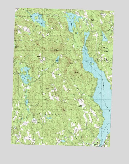
Winnisquam Lake, NH USGS Topographic Map
Click on map above to begin viewing in our Map Viewer.

This topographic map contains these locations and features:
Feature Name Type Latitude Longitude GNIS ID View Map
Arbutus Hill PondLakeN43.6028°W71.5717°2099752View Map
Bachelder HillSummitN43.5676°W71.5484°865302View Map
Bay Meeting House (historical)ChurchN43.5381°W71.5362°1914984View Map
Bay MeetinghouseLocaleN43.5381°W71.5362°865419View Map
Beaver Meadow PondLakeN43.6017°W71.5561°2099751View Map
Black BrookStreamN43.5440°W71.5229°865611View Map
Cawley PondLakeN43.5387°W71.6059°866057View Map
Chapman BrookStreamN43.5087°W71.5154°866108View Map
Chemung State ForestForestN43.6029°W71.5412°1915016View Map
Crockett CemeteryCemeteryN43.5091°W71.6148°866405View Map
Crocketts LedgeCliffN43.6081°W71.5592°2098285View Map
Dolloff BrookStreamN43.6220°W71.5604°866612View Map
Double Dammed PondReservoirN43.6019°W71.5622°2099750View Map
Eames Recreation and Wildlife AreaParkN43.6000°W71.5667°2098207View Map
Eastman CemeteryCemeteryN43.5641°W71.5652°866741View Map
Eastman HillSummitN43.5520°W71.5784°866744View Map
Edgerly SchoolSchoolN43.5990°W71.5862°866763View Map
Emerson BrookStreamN43.5295°W71.6023°866793View Map
GazaPopulated PlaceN43.5220°W71.5945°867038View Map
Giles BrookStreamN43.5351°W71.6042°867062View Map
Hadley BrookStreamN43.5629°W71.6148°867297View Map
Hamel State ForestForestN43.5926°W71.5106°1915066View Map
Hamlin Recreation and Conservation AreaParkN43.6042°W71.5583°2098205View Map
Hermit BrookStreamN43.5537°W71.6051°867461View Map
Hermit LakeReservoirN43.5634°W71.6088°867463View Map
Hopkinson HillSummitN43.5329°W71.5604°867593View Map
Hunkins PondLakeN43.5042°W71.5588°867677View Map
Huston-Morgan State ForestForestN43.5806°W71.5079°1915069View Map
Laconia Christian SchoolSchoolN43.5984°W71.5215°2500252View Map
Ladd MountainSummitN43.5762°W71.5554°867920View Map
Lake WinnisquamReservoirN43.5363°W71.5110°870960View Map
Lakeland SchoolSchoolN43.6218°W71.5458°1915089View Map
Leavitt MountainSummitN43.5879°W71.5740°867970View Map
Leighton MountainSummitN43.5864°W71.5869°2420614View Map
Loon IslandIslandN43.5904°W71.5345°868159View Map
Maple GroveLocaleN43.6122°W71.5664°2098284View Map
Meredith CenterPopulated PlaceN43.6142°W71.5292°868386View Map
Meredith Center Fire StationBuildingN43.6162°W71.5384°2605110View Map
Meredith HillPopulated PlaceN43.5815°W71.5915°868387View Map
Merrill BrookStreamN43.6115°W71.5926°868393View Map
Mud PondLakeN43.6035°W71.5450°868644View Map
North SanborntonPopulated PlaceN43.5520°W71.6095°868814View Map
Oakland CemeteryCemeteryN43.6190°W71.5392°868880View Map
Patterson BrookStreamN43.5031°W71.5334°869025View Map
Pemingewasset LakeLakeN43.6151°W71.5947°869058View Map
Pickerel PondLakeN43.5999°W71.5107°869124View Map
Pinnacle ParkParkN43.6056°W71.6234°869212View Map
Pot IslandIslandN43.5495°W71.5129°869316View Map
Randlett PondLakeN43.5788°W71.5690°869437View Map
Robinson CemeteryCemeteryN43.6151°W71.5309°869545View Map
Rollins PondLakeN43.5321°W71.6043°869594View Map
Saddle HillSummitN43.5920°W71.5973°869671View Map
Snow Dragon MountainSummitN43.5686°W71.5603°2118218View Map
Steele HillSummitN43.5481°W71.5729°870160View Map
Storage Dam at Weeks MillDamN43.5551°W71.6095°1774812View Map
Surowiec FarmLocaleN43.5064°W71.6014°2611151View Map
Swain State ForestForestN43.5798°W71.5195°1915170View Map
Swamp PondLakeN43.5909°W71.5430°870299View Map
Three IslandsIslandN43.5759°W71.5242°870425View Map
Town of SanborntonCivilN43.5277°W71.6016°873715View Map
Union CemeteryCemeteryN43.5429°W71.5454°870574View Map
Wallis BrookStreamN43.5048°W71.5342°870653View Map
White Mountain LedgeCliffN43.6111°W71.5608°2098283View Map
Wickwas LakeReservoirN43.6147°W71.5522°870883View Map
Wickwas Lake DamDamN43.6167°W71.5395°1774979View Map
WinnisquamPopulated PlaceN43.5015°W71.5120°870959View Map
Winnisquam Fire DepartmentBuildingN43.5009°W71.5095°2658841View Map
Winnisquam Post OfficePost OfficeN43.5002°W71.5165°1915196View Map
WLNH-AM (Laconia)TowerN43.5076°W71.5162°873318View Map

Note: Coordinates in the location and feature list above are referenced to NAD83 datum.


Copyright (C) 2008-2024 Ryan Niemi / Sunset Dynamics ... All Rights Reserved