TopoQuest Logo
Do you find TopoQuest useful?
Help keep TopoQuest running and adding new maps/features by donating!
Bitcoin:  19c7KJd3qBynnjoSw5npx9KScwjBe4ifkT
Litecoin:  LXs6TkuXGGXo1vDsWCkWVdjQX94eUKd6ui
Home View Maps Find Maps Find Places Resources & Links


Zaca Lake, California Topographic Map

USGS Map Title: Zaca Lake, CA
USGS Map MRC: 34120G1
DRG (GeoTIFF) Download: o34120g1.tif


Neighboring USGS Topographic Map Quads:


  Tepusquet Canyon, CA  
34120H2
 

  Manzanita Mountain, CA  
34120H1
 

  Bates Canyon, CA  
34119H8
 

  Foxen Canyon, CA  
34120G2
 

  Zaca Lake, CA  
34120G1
 

  Bald Mountain, CA  
34119G8
 

  Zaca Creek, CA  
34120F2
 

  Los Olivos, CA  
34120F1
 

  Figueroa Mountain, CA  
34119F8


Map MRC Location:

N35°
W121°
N35°
W120°
H8 H7 H6 H5 H4 H3 H2 H1
G8 G7 G6 G5 G4 G3 G2 G1
F8 F7 F6 F5 F4 F3 F2 F1
E8 E7 E6 E5 E4 E3 E2 E1
D8 D7 D6 D5 D4 D3 D2 D1
C8 C7 C6 C5 C4 C3 C2 C1
B8 B7 B6 B5 B4 B3 B2 B1
A8 A7 A6 A5 A4 A3 A2 A1
N34°
W121°
N34°
W120°

Zaca Lake, CA USGS 1:24K Topographic Map Preview:
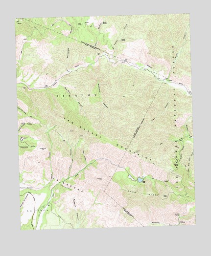
Zaca Lake, CA USGS Topographic Map
Click on map above to begin viewing in our Map Viewer.

This topographic map contains these locations and features:
Feature Name Type Latitude Longitude GNIS ID View Map
Alkali CanyonValleyN34.8514°W120.0682°238523View Map
Asphaltum MineMineN34.8041°W120.1221°238810View Map
Ballard CampgroundLocaleN34.7508°W120.0124°238939View Map
Ballard CampgroundLocaleN34.7511°W120.0124°275402View Map
Bee RockPillarN34.8339°W120.1046°239150View Map
Bee Rock CanyonValleyN34.8350°W120.0963°239151View Map
Bell CanyonValleyN34.7794°W120.0907°239172View Map
Dry CreekStreamN34.8028°W120.0054°241632View Map
Honeymoon FlatFlatN34.7978°W120.1085°243615View Map
Horse CanyonValleyN34.8366°W120.0176°243648View Map
Hunter SpringSpringN34.8708°W120.0624°243740View Map
Jesus CanyonValleyN34.7761°W120.1079°244058View Map
La Jolla SpringSpringN34.7566°W120.0127°244421View Map
La ZacaCivilN34.7528°W120.1232°244476View Map
Liebe CanyonValleyN34.7866°W120.0771°244785View Map
Lion CanyonValleyN34.8333°W120.0163°244883View Map
Lookout MountainSummitN34.7786°W120.0663°1660944View Map
Pickett CorralLocaleN34.8708°W120.0782°247444View Map
Rattlesnake CanyonValleyN34.8439°W120.0874°247995View Map
Sluice Box CampgroundLocaleN34.8641°W120.0032°275401View Map
Sulphur CreekStreamN34.8008°W120.0090°250040View Map
Sulphur SpringSpringN34.7858°W120.0121°250048View Map
Tunnel CanyonValleyN34.8489°W120.0560°250698View Map
Tunnel RanchLocaleN34.8483°W120.0479°250700View Map
Tunnel SpringSpringN34.8614°W120.0496°250701View Map
West Fork Mill CreekStreamN34.8014°W120.0004°274437View Map
Wildhorse CanyonValleyN34.8458°W120.0710°251556View Map
Zaca LakeLakeN34.7776°W120.0399°251898View Map
Zaca PeakSummitN34.7678°W120.0240°251899View Map
Zaca RidgeRidgeN34.7680°W120.0376°251900View Map

Note: Coordinates in the location and feature list above are referenced to NAD83 datum.


Copyright (C) 2008-2024 Ryan Niemi / Sunset Dynamics ... All Rights Reserved