TopoQuest Logo
Do you find TopoQuest useful?
Help keep TopoQuest running and adding new maps/features by donating!
Bitcoin:  19c7KJd3qBynnjoSw5npx9KScwjBe4ifkT
Litecoin:  LXs6TkuXGGXo1vDsWCkWVdjQX94eUKd6ui
Home View Maps Find Maps Find Places Resources & Links


Burnet, Texas Topographic Map

USGS Map Title: Burnet, TX
USGS Map MRC: 30098G2
DRG (GeoTIFF) Download: o30098g2.tif


Neighboring USGS Topographic Map Quads:


  Naruna, TX  
30098H3
 

  Lake Victor, TX  
30098H2
 

  Bachelor Peak, TX  
30098H1
 

  Council Creek, TX  
30098G3
 

  Burnet, TX  
30098G2
 

  Joppa, TX  
30098G1
 

  Longhorn Cavern, TX  
30098F3
 

  Mormon Mill, TX  
30098F2
 

  Bertram, TX  
30098F1


Map MRC Location:

N31°
W99°
N31°
W98°
H8 H7 H6 H5 H4 H3 H2 H1
G8 G7 G6 G5 G4 G3 G2 G1
F8 F7 F6 F5 F4 F3 F2 F1
E8 E7 E6 E5 E4 E3 E2 E1
D8 D7 D6 D5 D4 D3 D2 D1
C8 C7 C6 C5 C4 C3 C2 C1
B8 B7 B6 B5 B4 B3 B2 B1
A8 A7 A6 A5 A4 A3 A2 A1
N30°
W99°
N30°
W98°

Burnet, TX USGS 1:24K Topographic Map Preview:
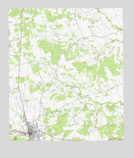
Burnet, TX USGS Topographic Map
Click on map above to begin viewing in our Map Viewer.

This topographic map contains these locations and features:
Feature Name Type Latitude Longitude GNIS ID View Map
Allen HospitalHospitalN30.7546°W98.2281°1350999View Map
Bethel CemeteryCemeteryN30.8577°W98.1636°1351942View Map
Bethel Community CenterLocaleN30.8466°W98.1681°1351959View Map
Burent Middle SchoolSchoolN30.7742°W98.2304°2003820View Map
BurnetPopulated PlaceN30.7582°W98.2284°1353341View Map
Burnet CemeteryCemeteryN30.7513°W98.2200°2766132View Map
Burnet City HallBuildingN30.7582°W98.2407°2753498View Map
Burnet CountyCivilN30.7883°W98.1824°1383812View Map
Burnet County Constable's Office Precinct 1BuildingN30.7572°W98.2119°2750570View Map
Burnet County Constable's Office Precinct 2BuildingN30.7573°W98.2121°2750685View Map
Burnet County CourthouseBuildingN30.7574°W98.2267°2030605View Map
Burnet County Sheriff's OfficeBuildingN30.7576°W98.2130°2750333View Map
Burnet Elementary SchoolSchoolN30.7642°W98.2265°2003818View Map
Burnet Fire DepartmentBuildingN30.7586°W98.2207°2552025View Map
Burnet High SchoolSchoolN30.7777°W98.2256°2003819View Map
Burnet Police DepartmentBuildingN30.7587°W98.2208°2750429View Map
Burnet Post OfficePost OfficeN30.7579°W98.2225°2731151View Map
Church of ChristChurchN30.7585°W98.2256°2016104View Map
City of BurnetCivilN30.7508°W98.2375°2409948View Map
Daugherty BranchStreamN30.7610°W98.2331°1355659View Map
Deiterich Ranch AirportAirportN30.7537°W98.1465°2675972View Map
First Baptist ChurchChurchN30.7663°W98.2286°2016097View Map
Fort Croghan Historical SiteParkN30.7568°W98.2375°1357583View Map
Fort Croghan MuseumBuildingN30.7560°W98.2339°2014256View Map
Frazier Family CemeteryCemeteryN30.8225°W98.2111°2766131View Map
KHLB-AM (Burnet)TowerN30.7680°W98.2306°1385520View Map
Odd Fellows CemeteryCemeteryN30.7505°W98.2182°2766134View Map
Old Burnet CemeteryCemeteryN30.7502°W98.2197°2766133View Map
Parsonage Baptist ChurchChurchN30.7585°W98.2256°2016100View Map
Pleasant Hill CemeteryCemeteryN30.8704°W98.1768°1365424View Map
Post MountainSummitN30.7521°W98.2445°1365630View Map
QUEST High SchoolSchoolN30.7610°W98.2268°2003821View Map
Robinson BranchStreamN30.7849°W98.1470°1366615View Map
Saint Matthew African Methodist Episcopal ChurchChurchN30.7563°W98.2170°2016096View Map
Stephenville Public LibraryBuildingN30.7574°W98.2045°2014779View Map
SummitLocaleN30.7516°W98.1689°1369386View Map
Temple Baptist ChurchChurchN30.7627°W98.2253°2016101View Map
Tommy White ParkParkN30.7605°W98.2406°1370005View Map
Wallace Riddell ParkParkN30.7577°W98.2192°2030033View Map

Note: Coordinates in the location and feature list above are referenced to NAD83 datum.


Copyright (C) 2008-2024 Ryan Niemi / Sunset Dynamics ... All Rights Reserved