TopoQuest Logo
Do you find TopoQuest useful?
Help keep TopoQuest running and adding new maps/features by donating!
Bitcoin:  19c7KJd3qBynnjoSw5npx9KScwjBe4ifkT
Litecoin:  LXs6TkuXGGXo1vDsWCkWVdjQX94eUKd6ui
Home View Maps Find Maps Find Places Resources & Links


Jacksonville, Arkansas Topographic Map

USGS Map Title: Jacksonville, AR
USGS Map MRC: 34092G1
DRG (GeoTIFF) Download: o34092g1.tif


Neighboring USGS Topographic Map Quads:


  Olmstead, AR  
34092H2
 

  Cabot, AR  
34092H1
 

  Oak Grove, AR  
34091H8
 

  McAlmont, AR  
34092G2
 

  Jacksonville, AR  
34092G1
 

  Lonoke, AR  
34091G8
 

  Sweet Home, AR  
34092F2
 

  Scott, AR  
34092F1
 

  Pettus, AR  
34091F8


Map MRC Location:

N35°
W93°
N35°
W92°
H8 H7 H6 H5 H4 H3 H2 H1
G8 G7 G6 G5 G4 G3 G2 G1
F8 F7 F6 F5 F4 F3 F2 F1
E8 E7 E6 E5 E4 E3 E2 E1
D8 D7 D6 D5 D4 D3 D2 D1
C8 C7 C6 C5 C4 C3 C2 C1
B8 B7 B6 B5 B4 B3 B2 B1
A8 A7 A6 A5 A4 A3 A2 A1
N34°
W93°
N34°
W92°

Jacksonville, AR USGS 1:24K Topographic Map Preview:
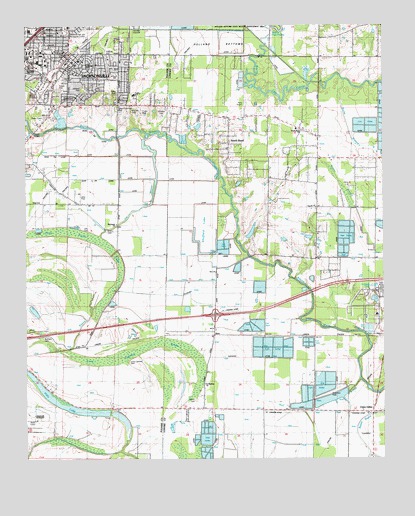
Jacksonville, AR USGS Topographic Map
Click on map above to begin viewing in our Map Viewer.

This topographic map contains these locations and features:
Feature Name Type Latitude Longitude GNIS ID View Map
Arkansas Emergency Transport - JacksonvilleBuildingN34.8515°W92.0894°2119075View Map
Baucum NurseryLocaleN34.7618°W92.1224°67425View Map
Bethany CemeteryCemeteryN34.7848°W92.1190°67429View Map
Burris BranchStreamN34.8598°W92.0143°76142View Map
Cherry CemeteryCemeteryN34.8162°W92.0968°67455View Map
Crestview Plaza Shopping CenterLocaleN34.8676°W92.1238°68183View Map
East Pulaski Volunteer Fire Department Station 1BuildingN34.7649°W92.0724°2116388View Map
Ellis CemeteryCemeteryN34.8165°W92.1054°48860View Map
Excell ParkParkN34.8604°W92.0938°67480View Map
Fireman ParkParkN34.8656°W92.0960°67488View Map
First Baptist ChurchChurchN34.8651°W92.1065°68243View Map
First Presbyterian ChurchChurchN34.8684°W92.1224°68255View Map
Forty Point LakeSwampN34.8145°W92.1081°49187View Map
Galloway ParkParkN34.8634°W92.1043°67512View Map
Hills LakeLakeN34.7658°W92.1123°74893View Map
Interchange 165CrossingN34.7915°W92.0590°59018View Map
Jackson Square Shopping CenterLocaleN34.8668°W92.1196°68338View Map
JacksonvillePopulated PlaceN34.8662°W92.1101°57978View Map
Jacksonville Branch LibraryBuildingN34.8679°W92.1146°68339View Map
Jacksonville City HallBuildingN34.8673°W92.1126°68340View Map
Jacksonville Elementary SchoolSchoolN34.8643°W92.1109°67542View Map
Jacksonville Fire Department Station 2BuildingN34.8666°W92.0960°68237View Map
Jacksonville Fire Department Station 2 AmbulanceBuildingN34.8665°W92.0961°2119082View Map
Jacksonville Fire Department Station 4BuildingN34.8459°W92.1200°68238View Map
Jacksonville Junior High SchoolSchoolN34.8635°W92.1233°2039243View Map
Jacksonville Middle SchoolSchoolN34.8674°W92.1243°2039242View Map
Jacksonville Police DepartmentBuildingN34.8685°W92.1247°2118681View Map
Jacksonville Post OfficePost OfficeN34.8668°W92.1207°84395View Map
Jacksonville School (historical)SchoolN34.8634°W92.0838°67544View Map
Jacksonville Shopping CenterLocaleN34.8687°W92.1165°68341View Map
Jeter ParkParkN34.8254°W92.1074°67545View Map
Johnson CemeteryCemeteryN34.8512°W92.0765°50677View Map
Johnson ParkParkN34.8568°W92.1046°67546View Map
Keller LakeReservoirN34.8155°W92.0462°81280View Map
Keller Lake DamDamN34.8134°W92.0485°81279View Map
KerrPopulated PlaceN34.7868°W92.0585°77398View Map
Lone Cypress BrakeSwampN34.7805°W92.0888°51394View Map
Lone Cypress CemeteryCemeteryN34.7784°W92.0887°51395View Map
Martin CemeteryCemeteryN34.7673°W92.0654°51703View Map
Martin School (historical)SchoolN34.7643°W92.0604°61331View Map
McCraw CemeteryCemeteryN34.8509°W92.0874°51810View Map
Meto (historical)Populated PlaceN34.7851°W92.0024°61333View Map
Mount Ararat ChurchChurchN34.8181°W92.0929°52258View Map
Mount Pisgah ChurchChurchN34.8598°W92.1013°52379View Map
Panola ChurchChurchN34.8223°W92.0238°77947View Map
Panola School (historical)SchoolN34.8226°W92.0238°61335View Map
Perrys AirportAirportN34.8519°W92.0477°83736View Map
Pleasant Hill Church (historical)ChurchN34.8179°W92.0232°61334View Map
Pleasure Park and Recreation CenterParkN34.8737°W92.1110°67649View Map
Reeds BridgeBridgeN34.8443°W92.1224°67660View Map
Saint Joe ChurchChurchN34.7659°W92.1032°54343View Map
Saint Joseph School (historical)SchoolN34.7651°W92.1046°67681View Map
Saint Matthew ChurchChurchN34.7718°W92.0624°78257View Map
Saint Paul ChurchChurchN34.7595°W92.0788°54446View Map
Shuffield LakeLakeN34.8165°W92.0624°75125View Map
South BendPopulated PlaceN34.8418°W92.0543°61337View Map
South Bend ChurchChurchN34.8484°W92.0399°55010View Map
South Bend Church (historical)ChurchN34.8312°W92.0396°61336View Map
South Bend Fire Department Station 1BuildingN34.8487°W92.0505°2117134View Map
South Bend School (historical)SchoolN34.8443°W92.0496°61338View Map
South Plaza Shopping CenterLocaleN34.8512°W92.1157°68555View Map
Southside High SchoolSchoolN34.8640°W92.1235°78415View Map
Stagecoach ParkParkN34.8545°W92.1121°67698View Map
Sunnyside Shopping CenterLocaleN34.8634°W92.1099°68566View Map
Taylor Elementary SchoolSchoolN34.8550°W92.0872°83585View Map
Township of GrayCivilN34.8308°W92.0388°68820View Map
Township of PulaskiCivilN34.7764°W92.0336°68831View Map
Union ValleyPopulated PlaceN34.7648°W92.0035°55834View Map
Union Valley School (historical)SchoolN34.7656°W92.0038°61332View Map

Note: Coordinates in the location and feature list above are referenced to NAD83 datum.


Copyright (C) 2008-2024 Ryan Niemi / Sunset Dynamics ... All Rights Reserved