TopoQuest Logo
Do you find TopoQuest useful?
Help keep TopoQuest running and adding new maps/features by donating!
Bitcoin:  19c7KJd3qBynnjoSw5npx9KScwjBe4ifkT
Litecoin:  LXs6TkuXGGXo1vDsWCkWVdjQX94eUKd6ui
Home View Maps Find Maps Find Places Resources & Links


Latanier, Louisiana Topographic Map

USGS Map Title: Latanier, LA
USGS Map MRC: 31092B3
DRG (GeoTIFF) Download: o31092b3.tif


Neighboring USGS Topographic Map Quads:


  Alexandria, LA  
31092C4
 

  Libuse, LA  
31092C3
 

  Buckeye, LA  
31092C2
 

  Woodworth East, LA  
31092B4
 

  Latanier, LA  
31092B3
 

  Effie, LA  
31092B2
 

  Lecompte, LA  
31092A4
 

  Cheneyville, LA  
31092A3
 

  Belle d'Eau, LA  
31092A2


Map MRC Location:

N32°
W93°
N32°
W92°
H8 H7 H6 H5 H4 H3 H2 H1
G8 G7 G6 G5 G4 G3 G2 G1
F8 F7 F6 F5 F4 F3 F2 F1
E8 E7 E6 E5 E4 E3 E2 E1
D8 D7 D6 D5 D4 D3 D2 D1
C8 C7 C6 C5 C4 C3 C2 C1
B8 B7 B6 B5 B4 B3 B2 B1
A8 A7 A6 A5 A4 A3 A2 A1
N31°
W93°
N31°
W92°

Latanier, LA USGS 1:24K Topographic Map Preview:
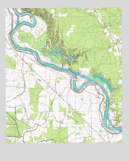
Latanier, LA USGS Topographic Map
Click on map above to begin viewing in our Map Viewer.

This topographic map contains these locations and features:
Feature Name Type Latitude Longitude GNIS ID View Map
Bayou LamourieStreamN31.1310°W92.3590°553478View Map
Bayou LatanierStreamN31.1310°W92.3568°553480View Map
Beaver Dam LandingLocaleN31.1738°W92.2974°551669View Map
Big LakeLakeN31.2078°W92.3220°553647View Map
Bonnegent LandingLocaleN31.2324°W92.3610°551675View Map
Cedar GrovePopulated PlaceN31.2494°W92.2793°543066View Map
Chatlin LakeLakeN31.1269°W92.3562°553959View Map
Compton Lake (historical)LakeN31.1813°W92.3168°551693View Map
Compton Lake CanalCanalN31.1635°W92.3251°534071View Map
Creole LandingLocaleN31.1810°W92.2821°551696View Map
Cummings LandingLocaleN31.2430°W92.3474°551697View Map
D A Smith LandingLocaleN31.2057°W92.3418°551699View Map
Dysant LandingLocaleN31.1682°W92.2649°551702View Map
Echo - Poland Volunteer Fire Department Station 1BuildingN31.1396°W92.2824°2672960View Map
Echo - Poland Volunteer Fire Department Station 2BuildingN31.1973°W92.3378°2672986View Map
Echo - Poland Volunteer Fire Department Station 3BuildingN31.1610°W92.3554°2672991View Map
Elbow LakeStreamN31.1413°W92.3410°534786View Map
Gum Point LandingLocaleN31.2188°W92.3679°551714View Map
Harris Ferry (historical)CrossingN31.1544°W92.2668°551716View Map
Hog LakeLakeN31.1839°W92.2693°554725View Map
Indian BayouStreamN31.1513°W92.3110°535903View Map
Jones Quarters LandingLocaleN31.1946°W92.3218°551723View Map
LatanierPopulated PlaceN31.2021°W92.3562°541125View Map
Latanier ChurchChurchN31.1385°W92.3487°536346View Map
Latanier LandingLocaleN31.2096°W92.3482°551728View Map
Latanier School (historical)SchoolN31.1377°W92.3465°551729View Map
Lick BayouStreamN31.1944°W92.3137°555038View Map
Lockhart LakeLakeN31.2058°W92.3114°555117View Map
Magda (historical)Populated PlaceN31.1396°W92.2835°551736View Map
Miller BluffCliffN31.2463°W92.3560°537125View Map
Mount Pleasant CemeteryCemeteryN31.1357°W92.2671°551742View Map
Mount Pleasant ChurchChurchN31.1357°W92.2671°537390View Map
New Morning Glory ChurchChurchN31.1485°W92.2551°537609View Map
Overton Lock and DamDamN31.1849°W92.3018°551108View Map
Palo Alto LandingLocaleN31.1916°W92.3049°551754View Map
Peart CemeteryCemeteryN31.2466°W92.3487°538036View Map
Pearts LandingLocaleN31.2413°W92.3432°551755View Map
PolandPopulated PlaceN31.1671°W92.2757°538313View Map
Poland Baptist ChurchChurchN31.1694°W92.2762°551762View Map
Poland High School (historical)SchoolN31.1513°W92.2740°551763View Map
Poland Junior High SchoolSchoolN31.1671°W92.2760°551764View Map
Richland (historical)Populated PlaceN31.1663°W92.3146°551767View Map
Riverview Baptist ChurchChurchN31.1991°W92.3521°555808View Map
Rodgers LandingLocaleN31.2121°W92.3496°551769View Map
Ruby Lookout TowerTowerN31.2494°W92.2710°558819View Map
Rush LandingLocaleN31.2041°W92.3407°551771View Map
Saint Lukes Church (historical)ChurchN31.1438°W92.2890°551774View Map
Saint Marks Church (historical)ChurchN31.1474°W92.2932°551777View Map
Smith LandingLocaleN31.2013°W92.3399°551783View Map
Spring BayouSwampN31.2046°W92.3287°539560View Map
Stonewall LandingLocaleN31.1807°W92.2912°551786View Map
Stonewalls (historical)Populated PlaceN31.1849°W92.2960°551787View Map
Tarkill LakeLakeN31.2030°W92.3062°556207View Map
Tiger LakeStreamN31.1424°W92.2929°556244View Map
WhittingtonPopulated PlaceN31.1774°W92.3315°551107View Map
Wilson BayouStreamN31.1252°W92.3421°556447View Map
Wilson PointPopulated PlaceN31.1457°W92.2546°543789View Map
Wilsons Ferry (historical)CrossingN31.1460°W92.2585°551882View Map
Wise CemeteryCemeteryN31.2168°W92.2523°540504View Map
Wise CemeteryCemeteryN31.2371°W92.3298°540505View Map
Wise Chapel (historical)ChurchN31.2166°W92.2529°551803View Map
Wises (historical)Populated PlaceN31.2341°W92.3418°551805View Map
Wises LandingLocaleN31.2349°W92.3435°551806View Map
Zion ChurchChurchN31.1560°W92.3007°556494View Map

Note: Coordinates in the location and feature list above are referenced to NAD83 datum.


Copyright (C) 2008-2024 Ryan Niemi / Sunset Dynamics ... All Rights Reserved