TopoQuest Logo
Do you find TopoQuest useful?
Help keep TopoQuest running and adding new maps/features by donating!
Bitcoin:  19c7KJd3qBynnjoSw5npx9KScwjBe4ifkT
Litecoin:  LXs6TkuXGGXo1vDsWCkWVdjQX94eUKd6ui
Home View Maps Find Maps Find Places Resources & Links


Marquette, Kansas Topographic Map

USGS Map Title: Marquette, KS
USGS Map MRC: 38097E7
DRG (GeoTIFF) Download: o38097e7.tif


Neighboring USGS Topographic Map Quads:


  Venango, KS  
38097F8
 

  Falun, KS  
38097F7
 

  Smolan, KS  
38097F6
 

  Langley, KS  
38097E8
 

  Marquette, KS  
38097E7
 

  Lindsborg, KS  
38097E6
 

  Windom, KS  
38097D8
 

  Windom NE, KS  
38097D7
 

  McPherson North, KS  
38097D6


Map MRC Location:

N39°
W98°
N39°
W97°
H8 H7 H6 H5 H4 H3 H2 H1
G8 G7 G6 G5 G4 G3 G2 G1
F8 F7 F6 F5 F4 F3 F2 F1
E8 E7 E6 E5 E4 E3 E2 E1
D8 D7 D6 D5 D4 D3 D2 D1
C8 C7 C6 C5 C4 C3 C2 C1
B8 B7 B6 B5 B4 B3 B2 B1
A8 A7 A6 A5 A4 A3 A2 A1
N38°
W98°
N38°
W97°

Marquette, KS USGS 1:24K Topographic Map Preview:
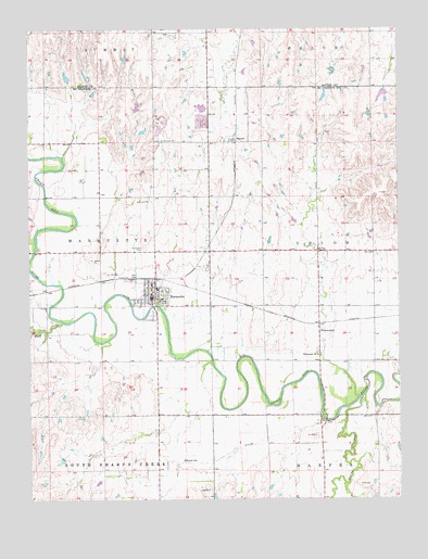
Marquette, KS USGS Topographic Map
Click on map above to begin viewing in our Map Viewer.

This topographic map contains these locations and features:
Feature Name Type Latitude Longitude GNIS ID View Map
City of MarquetteCivilN38.5557°W97.8344°2395018View Map
Edwards CreekStreamN38.5208°W97.7759°477057View Map
Elim Lutheran CemeteryCemeteryN38.5583°W97.8420°2673311View Map
Elim Lutheran ChurchChurchN38.5567°W97.8353°2690718View Map
Freemont Lutheran ChurchChurchN38.5382°W97.7780°477058View Map
FreemountPopulated PlaceN38.5453°W97.7775°484802View Map
Kansas Motorcycle MuseumBuildingN38.5542°W97.8335°2692623View Map
MackiePopulated PlaceN38.5958°W97.8048°484803View Map
MarquettePopulated PlaceN38.5556°W97.8337°477060View Map
Marquette CemeteryCemeteryN38.5665°W97.8364°477061View Map
Marquette City HallBuildingN38.5539°W97.8342°2693067View Map
Marquette Community LibraryBuildingN38.5541°W97.8341°2694854View Map
Marquette Elementary SchoolSchoolN38.5558°W97.8324°2497335View Map
Marquette Emergency Medical ServicesBuildingN38.5529°W97.8336°2696506View Map
Marquette High SchoolSchoolN38.5392°W97.8320°480701View Map
Marquette Historical MuseumBuildingN38.5545°W97.8335°2692624View Map
Marquette Police DepartmentBuildingN38.5539°W97.8342°2504121View Map
Marquette Post OfficePost OfficeN38.5548°W97.8335°2693846View Map
Marquette Sewer Treatment PlantLocaleN38.5499°W97.8153°2691985View Map
Marquette United Methodist ChurchChurchN38.5537°W97.8382°2690260View Map
McPherson County Rural Fire District 2 MarquetteBuildingN38.5575°W97.8333°2111604View Map
Range School MuseumBuildingN38.5546°W97.8335°2692625View Map
Sharps CreekStreamN38.5270°W97.7631°477056View Map
Team Marketing Alliance Grain Elevator Number 25LocaleN38.5585°W97.8344°2695399View Map
Township of MarquetteCivilN38.5661°W97.8694°477054View Map
Township of UnionCivilN38.5657°W97.7587°477062View Map
Valley Community ChurchChurchN38.5566°W97.8334°2690871View Map
Wolf CreekStreamN38.5470°W97.8639°477059View Map

Note: Coordinates in the location and feature list above are referenced to NAD83 datum.


Copyright (C) 2008-2024 Ryan Niemi / Sunset Dynamics ... All Rights Reserved