TopoQuest Logo
Do you find TopoQuest useful?
Help keep TopoQuest running and adding new maps/features by donating!
Bitcoin:  19c7KJd3qBynnjoSw5npx9KScwjBe4ifkT
Litecoin:  LXs6TkuXGGXo1vDsWCkWVdjQX94eUKd6ui
Home View Maps Find Maps Find Places Resources & Links


Cape Charles, Virginia Topographic Map

USGS Map Title: Cape Charles, VA
USGS Map MRC: 37076C1
DRG (GeoTIFF) Download: o37076c1.tif


Neighboring USGS Topographic Map Quads:


  Bethel Beach, VA  
37076D2
 

  West of Franktown, VA  
37076D1
 

  Franktown, VA  
37075D8
 

  East of New Point Comfort, VA  
37076C2
 

  Cape Charles, VA  
37076C1
 

  Cheriton, VA  
37075C8
 

  East of Poquoson East, VA  
37076B2
 

  Elliotts Creek, VA  
37076B1
 

  Townsend, VA  
37075B8


Map MRC Location:

N38°
W77°
N38°
W76°
H8 H7 H6 H5 H4 H3 H2 H1
G8 G7 G6 G5 G4 G3 G2 G1
F8 F7 F6 F5 F4 F3 F2 F1
E8 E7 E6 E5 E4 E3 E2 E1
D8 D7 D6 D5 D4 D3 D2 D1
C8 C7 C6 C5 C4 C3 C2 C1
B8 B7 B6 B5 B4 B3 B2 B1
A8 A7 A6 A5 A4 A3 A2 A1
N37°
W77°
N37°
W76°

Cape Charles, VA USGS 1:24K Topographic Map Preview:
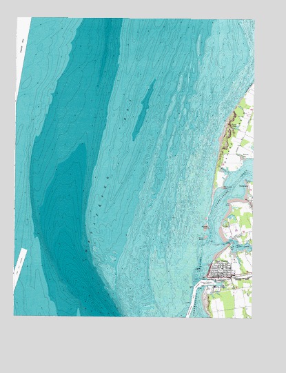
Cape Charles, VA USGS Topographic Map
Click on map above to begin viewing in our Map Viewer.

This topographic map contains these locations and features:
Feature Name Type Latitude Longitude GNIS ID View Map
Bay Creek MarinaHarborN37.2792°W76.0094°2520084View Map
Baycreek Golf ClubLocaleN37.2501°W76.0073°2520142View Map
Cape CharlesPopulated PlaceN37.2679°W76.0174°1492707View Map
Cape Charles Baptist ChurchChurchN37.2685°W76.0149°1739168View Map
Cape Charles City Harbor Northern LightLocaleN37.2662°W76.0280°1739169View Map
Cape Charles Country ClubLocaleN37.2737°W76.0088°1739170View Map
Cape Charles Elementary SchoolSchoolN37.2707°W76.0155°1739171View Map
Cape Charles Graded School (historical)SchoolN37.2632°W76.0097°1739172View Map
Cape Charles HarborBayN37.2654°W76.0213°1464429View Map
Cape Charles Harbor ChannelChannelN37.2610°W76.0291°1480211View Map
Cape Charles Historic DistrictParkN37.2704°W76.0152°1739173View Map
Cape Charles Historical Society MuseumBuildingN37.2687°W76.0082°2520499View Map
Cape Charles Police ChiefBuildingN37.2671°W76.0151°2331928View Map
Cape Charles Police DepartmentBuildingN37.2674°W76.0149°2086105View Map
Cape Charles Post OfficePost OfficeN37.2683°W76.0179°1739175View Map
Cape Charles Presbyterian ChurchChurchN37.2693°W76.0180°1739176View Map
Cape Charles Town HallBuildingN37.2676°W76.0147°1739177View Map
Cape Charles Volunteer Fire CompanyBuildingN37.2674°W76.0147°2086099View Map
CherrystonePopulated PlaceN37.3062°W76.0016°1492749View Map
Cherrystone Bar LightLocaleN37.2565°W76.0324°1739186View Map
Cherrystone Channel Light 13LocaleN37.2707°W76.0274°1739187View Map
Cherrystone InletBayN37.2918°W76.0163°1464790View Map
Custis PondSwampN37.3296°W76.0091°1465554View Map
District 2CivilN37.2586°W76.0601°1927206View Map
Emmanuel Episcopal ChurchChurchN37.2693°W76.0127°1739197View Map
First Baptist ChurchChurchN37.2715°W76.0133°1739201View Map
Holiness Church (historical)ChurchN37.2562°W76.0166°1739213View Map
Kings CreekStreamN37.2815°W76.0141°1469017View Map
Mill CreekStreamN37.3012°W76.0044°1470503View Map
Mill PointCapeN37.2987°W76.0116°1470526View Map
Nassawango Mill PondReservoirN37.2589°W76.0200°1668958View Map
North Jetty LightLocaleN37.2662°W76.0244°1739231View Map
Northampton Memorial LibraryBuildingN37.2693°W76.0149°1739235View Map
Old Orchard PointCapeN37.3060°W76.0155°1471860View Map
Owens LandingLocaleN37.2824°W76.0105°1493384View Map
Point Farm HeliportAirportN37.3099°W76.0158°1498615View Map
Remus CreekGutN37.3118°W76.0138°1473148View Map
Saint Charles Roman Catholic ChurchChurchN37.2685°W76.0130°1739248View Map
Saint Stephens African Methodist Episcopal ChurchChurchN37.2724°W76.0149°1739249View Map
Sandy IslandIslandN37.2846°W76.0249°1474022View Map
Savage NeckCapeN37.3321°W76.0030°1474066View Map
School of the Holy Family (historical)SchoolN37.2687°W76.0130°1739250View Map
Tankards BeachBeachN37.3471°W76.0019°1493686View Map
Town of Cape CharlesCivilN37.2572°W76.0093°2390767View Map
Trinity Methodist ChurchChurchN37.2687°W76.0155°1739259View Map
Wescoat CoveBayN37.3182°W76.0058°1476451View Map
Wescoat PointCapeN37.2904°W76.0238°1477939View Map
WKSV-FM (Cape Charles)TowerN37.2632°W76.0127°1498973View Map
York Spit ChannelChannelN37.2699°W76.1227°1474355View Map

Note: Coordinates in the location and feature list above are referenced to NAD83 datum.


Copyright (C) 2008-2024 Ryan Niemi / Sunset Dynamics ... All Rights Reserved