TopoQuest Logo
Do you find TopoQuest useful?
Help keep TopoQuest running and adding new maps/features by donating!
Bitcoin:  19c7KJd3qBynnjoSw5npx9KScwjBe4ifkT
Litecoin:  LXs6TkuXGGXo1vDsWCkWVdjQX94eUKd6ui
Home View Maps Find Maps Find Places Resources & Links


Somerville, Alabama Topographic Map

USGS Map Title: Somerville, AL
USGS Map MRC: 34086D7
DRG (GeoTIFF) Download: o34086d7.tif


Neighboring USGS Topographic Map Quads:


  Decatur, AL  
34086E8
 

  Mason Ridge, AL  
34086E7
 

  Triana, AL  
34086E6
 

  Hartselle, AL  
34086D8
 

  Somerville, AL  
34086D7
 

  Center Grove, AL  
34086D6
 

  Falkville, AL  
34086C8
 

  Eva, AL  
34086C7
 

  Lawrence Cove, AL  
34086C6


Map MRC Location:

N35°
W87°
N35°
W86°
H8 H7 H6 H5 H4 H3 H2 H1
G8 G7 G6 G5 G4 G3 G2 G1
F8 F7 F6 F5 F4 F3 F2 F1
E8 E7 E6 E5 E4 E3 E2 E1
D8 D7 D6 D5 D4 D3 D2 D1
C8 C7 C6 C5 C4 C3 C2 C1
B8 B7 B6 B5 B4 B3 B2 B1
A8 A7 A6 A5 A4 A3 A2 A1
N34°
W87°
N34°
W86°

Somerville, AL USGS 1:24K Topographic Map Preview:
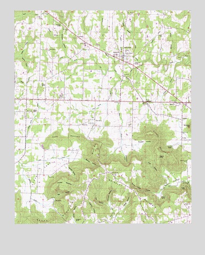
Somerville, AL USGS Topographic Map
Click on map above to begin viewing in our Map Viewer.

This topographic map contains these locations and features:
Feature Name Type Latitude Longitude GNIS ID View Map
Barnes HollowValleyN34.4129°W86.8261°113495View Map
Barnetts Chapel ChurchChurchN34.4651°W86.8178°154201View Map
Bethel ChurchChurchN34.4968°W86.7697°139704View Map
Bethlehem Church (historical)ChurchN34.4407°W86.8731°1700445View Map
Brindley CemeteryCemeteryN34.4340°W86.8192°114921View Map
Brindley HollowValleyN34.4215°W86.7883°114923View Map
Brindley Hollow SpringSpringN34.4182°W86.7904°148959View Map
Buckeye HollowValleyN34.3859°W86.8086°115139View Map
Bunker BranchStreamN34.4712°W86.7800°115205View Map
Campbell CemeteryCemeteryN34.4756°W86.7969°115492View Map
Cave HollowValleyN34.4051°W86.7753°115718View Map
Cedar CoveBasinN34.4054°W86.8578°115738View Map
Cedar MountainSummitN34.4254°W86.8283°115804View Map
Center Point School (historical)SchoolN34.4043°W86.8581°139727View Map
Childers SpringSpringN34.3908°W86.7713°116044View Map
Childs HollowValleyN34.3773°W86.8336°116050View Map
Cooper MountainSummitN34.4284°W86.7789°116586View Map
Devils Cellar HollowValleyN34.3929°W86.7747°117250View Map
Dripping SpringSpringN34.4138°W86.7727°117477View Map
Edmundson HollowValleyN34.4157°W86.7975°117872View Map
England CreekStreamN34.4645°W86.8044°117989View Map
Fairview CemeteryCemeteryN34.4026°W86.8514°118136View Map
Fairview MountainSummitN34.4004°W86.8397°118154View Map
Fairview SchoolSchoolN34.4490°W86.8433°151768View Map
Garner CemeteryCemeteryN34.4251°W86.7986°151229View Map
Garner CemeteryCemeteryN34.4320°W86.7942°118839View Map
Gill CreekStreamN34.4590°W86.7997°118954View Map
Glasscott SpringSpringN34.4203°W86.7638°119023View Map
Gum SpringPopulated PlaceN34.4362°W86.8186°156440View Map
Gum Spring CreekStreamN34.4593°W86.7997°119485View Map
Gum Springs Baptist ChurchChurchN34.4365°W86.8183°151231View Map
Gum Springs CemeteryCemeteryN34.4373°W86.8186°139795View Map
Gum Springs School (historical)SchoolN34.4355°W86.8172°139796View Map
HendersonPopulated PlaceN34.4851°W86.8311°156466View Map
Houston CemeteryCemeteryN34.4859°W86.7708°120460View Map
Ivy HollowValleyN34.3859°W86.8086°120734View Map
Joiner BranchStreamN34.4701°W86.7847°120972View Map
Key CemeteryCemeteryN34.3901°W86.8492°121173View Map
Key HollowValleyN34.3879°W86.8483°121175View Map
Key SpringSpringN34.3886°W86.8461°121176View Map
Leemon CemeteryCemeteryN34.4890°W86.7653°154192View Map
Livingston SpringSpringN34.3768°W86.8315°121930View Map
Lovers LeapCliffN34.3951°W86.7542°122065View Map
Maple BranchStreamN34.4693°W86.8261°122265View Map
Moats HollowValleyN34.4029°W86.7525°122917View Map
Moats SpringSpringN34.3988°W86.7681°148986View Map
Morgan CountyCivilN34.4535°W86.8529°161578View Map
Morgan County Farm (historical)LocaleN34.4187°W86.7914°1700446View Map
Mount Hope ChurchChurchN34.4526°W86.7875°139536View Map
Mount Hope ChurchChurchN34.4387°W86.7736°123228View Map
Mount Hope Church (historical)ChurchN34.4387°W86.7739°139535View Map
Mount TaborPopulated PlaceN34.4407°W86.8667°156754View Map
Mount Tabor CemeteryCemeteryN34.4381°W86.8681°139539View Map
Mount Tabor Methodist ChurchChurchN34.4382°W86.8675°139540View Map
Mount Tabor School (historical)SchoolN34.4398°W86.8664°139541View Map
Mount View ChurchChurchN34.4048°W86.8067°152517View Map
Mountain View School (historical)SchoolN34.4051°W86.8064°139544View Map
Negro MountainSummitN34.3865°W86.8356°123685View Map
Nelson CemeteryCemeteryN34.4731°W86.7592°123693View Map
Nelson HollowValleyN34.4715°W86.7619°123699View Map
New Center Baptist ChurchChurchN34.4759°W86.8519°139552View Map
New Center CemeteryCemeteryN34.4773°W86.8508°139551View Map
New Center CemeteryCemeteryN34.4770°W86.8519°123737View Map
New Center School (historical)SchoolN34.4759°W86.8519°139553View Map
Northern BranchStreamN34.4654°W86.7919°124021View Map
Northern SpringSpringN34.4743°W86.7971°124022View Map
Oakes HollowValleyN34.3818°W86.8006°124146View Map
Oden Ridge Volunteer Fire Department Station 2BuildingN34.4054°W86.8097°2683299View Map
Oldacre HollowValleyN34.3773°W86.8186°124272View Map
Outlaw SpringSpringN34.4565°W86.8558°124328View Map
Pannell HollowValleyN34.4087°W86.8397°124398View Map
PencePopulated PlaceN34.4493°W86.7589°139566View Map
Pine Grove School (historical)SchoolN34.4468°W86.7842°139568View Map
Roan BranchStreamN34.4556°W86.8047°125680View Map
Robertson BranchStreamN34.4112°W86.8722°125704View Map
Shiloh Baptist ChurchChurchN34.4454°W86.7625°153429View Map
Shiloh CemeteryCemeteryN34.4459°W86.7625°139606View Map
Six MilePopulated PlaceN34.4240°W86.7564°157067View Map
Six Mile School (historical)SchoolN34.4234°W86.8172°139609View Map
Slayton CemeteryCemeteryN34.4804°W86.8689°154210View Map
Sleighton SpringSpringN34.4815°W86.8647°149002View Map
Sobotka Mill (historical)LocaleN34.4468°W86.8575°139613View Map
SomervillePopulated PlaceN34.4731°W86.7986°127103View Map
Somerville Area Volunteer Emergency ServicesBuildingN34.4691°W86.7986°2682930View Map
Somerville CemeteryCemeteryN34.4709°W86.8014°139614View Map
Somerville Church of GodChurchN34.4356°W86.8244°139615View Map
Somerville DivisionCivilN34.4933°W86.8004°165916View Map
Somerville Police DepartmentBuildingN34.4729°W86.7989°2751960View Map
Somerville Post OfficePost OfficeN34.4727°W86.8023°166622View Map
Somerville SchoolSchoolN34.4693°W86.7908°127104View Map
StringerPopulated PlaceN34.4356°W86.7564°157119View Map
Stringer BranchStreamN34.4698°W86.7581°127467View Map
Town of SomervilleCivilN34.4651°W86.7875°2407365View Map
Turney CrossroadsPopulated PlaceN34.4465°W86.7839°157180View Map
Turney SpringSpringN34.4473°W86.8528°149008View Map
Vinsant HollowValleyN34.4845°W86.8439°128467View Map
Ward ChapelChurchN34.4781°W86.7978°153884View Map
Waugh CemeteryCemeteryN34.4331°W86.8275°153903View Map
Whiteoak HollowValleyN34.4740°W86.8386°128907View Map
Whiteoak SpringSpringN34.4922°W86.8425°128908View Map
Whitten SpringSpringN34.4407°W86.8619°153981View Map
Willis HollowValleyN34.4879°W86.7931°129053View Map
Wilson MountainSummitN34.4187°W86.8181°129090View Map
Wilson SpringSpringN34.4161°W86.8159°149013View Map
Wolfden HollowValleyN34.4734°W86.8694°129176View Map

Note: Coordinates in the location and feature list above are referenced to NAD83 datum.


Copyright (C) 2008-2024 Ryan Niemi / Sunset Dynamics ... All Rights Reserved