TopoQuest Logo
Do you find TopoQuest useful?
Help keep TopoQuest running and adding new maps/features by donating!
Bitcoin:  19c7KJd3qBynnjoSw5npx9KScwjBe4ifkT
Litecoin:  LXs6TkuXGGXo1vDsWCkWVdjQX94eUKd6ui
Home View Maps Find Maps Find Places Resources & Links


Wadena, Minnesota Topographic Map

USGS Map Title: Wadena, MN
USGS Map MRC: 46095D2
DRG (GeoTIFF) Download: o46095d2.tif


Neighboring USGS Topographic Map Quads:


  New York Mills East, MN  
46095E3
 

  Sebeka SW, MN  
46095E2
 

  Blue Grass, MN  
46095E1
 

  Deer Creek, MN  
46095D3
 

  Wadena, MN  
46095D2
 

  Verndale, MN  
46095D1
 

  Henning SE, MN  
46095C3
 

  Wrightstown, MN  
46095C2
 

  Bertha, MN  
46095C1


Map MRC Location:

N47°
W96°
N47°
W95°
H8 H7 H6 H5 H4 H3 H2 H1
G8 G7 G6 G5 G4 G3 G2 G1
F8 F7 F6 F5 F4 F3 F2 F1
E8 E7 E6 E5 E4 E3 E2 E1
D8 D7 D6 D5 D4 D3 D2 D1
C8 C7 C6 C5 C4 C3 C2 C1
B8 B7 B6 B5 B4 B3 B2 B1
A8 A7 A6 A5 A4 A3 A2 A1
N46°
W96°
N46°
W95°

Wadena, MN USGS 1:24K Topographic Map Preview:
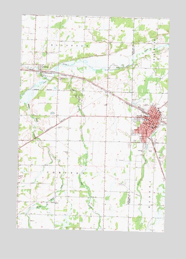
Wadena, MN USGS Topographic Map
Click on map above to begin viewing in our Map Viewer.

This topographic map contains these locations and features:
Feature Name Type Latitude Longitude GNIS ID View Map
Alliance ChurchChurchN46.3905°W95.2186°639293View Map
Bluff CreekStreamN46.4614°W95.2261°640309View Map
BlufftonPopulated PlaceN46.4691°W95.2331°640313View Map
BlufftonLocaleN46.4667°W95.2319°2073120View Map
Bluffton Fire DepartmentBuildingN46.4678°W95.2318°2666485View Map
Bluffton Post Office (historical)Post OfficeN46.4692°W95.2328°2073118View Map
City of BlufftonCivilN46.4697°W95.2337°2394210View Map
City of WadenaCivilN46.4451°W95.1282°2397160View Map
Compton CemeteryCemeteryN46.4202°W95.2086°641427View Map
Compton ChurchChurchN46.4052°W95.2492°641428View Map
Gustafva CemeteryCemeteryN46.4344°W95.2184°644542View Map
Oak CreekStreamN46.4714°W95.2067°648791View Map
Saint Ann' CemeteryCemeteryN46.4372°W95.1497°650507View Map
Saint Anns SchoolSchoolN46.4361°W95.1378°650509View Map
Saint John's Catholic ChurchChurchN46.4692°W95.2328°2073117View Map
Saint John's Catholic Church CemeteryCemeteryN46.4694°W95.2305°2072719View Map
Sonrise Christian SchoolSchoolN46.4692°W95.2328°2073116View Map
Southbrook ChurchChurchN46.4222°W95.1450°652358View Map
Township of ComptonCivilN46.4125°W95.2178°663858View Map
Tri - County HospitalHospitalN46.4458°W95.1340°2697200View Map
Tri-County HeliportAirportN46.4464°W95.1334°660454View Map
WadenaPopulated PlaceN46.4425°W95.1361°653712View Map
Wadena CemeteryCemeteryN46.4388°W95.1497°653713View Map
Wadena County JailBuildingN46.4380°W95.1398°2758697View Map
Wadena County Sheriff's OfficeBuildingN46.4380°W95.1397°2758500View Map
Wadena Fire DepartmentBuildingN46.4383°W95.1362°2666138View Map
Wadena Municipal AirportAirportN46.4503°W95.2109°660453View Map
Wadena Police DepartmentBuildingN46.4383°W95.1362°2758547View Map
West Wind EstatesPopulated PlaceN46.4692°W95.2328°2073119View Map

Note: Coordinates in the location and feature list above are referenced to NAD83 datum.


Copyright (C) 2008-2024 Ryan Niemi / Sunset Dynamics ... All Rights Reserved