TopoQuest Logo
Do you find TopoQuest useful?
Help keep TopoQuest running and adding new maps/features by donating!
Bitcoin:  19c7KJd3qBynnjoSw5npx9KScwjBe4ifkT
Litecoin:  LXs6TkuXGGXo1vDsWCkWVdjQX94eUKd6ui
Home View Maps Find Maps Find Places Resources & Links


Cleveland, South Carolina Topographic Map

USGS Map Title: Cleveland, SC
USGS Map MRC: 35082A5
DRG (GeoTIFF) Download: o35082a5.tif


Neighboring USGS Topographic Map Quads:


  Brevard, NC  
35082B6
 

  Standingstone Mountain, SC  
35082B5
 

  Zirconia, NC  
35082B4
 

  Table Rock, SC  
35082A6
 

  Cleveland, SC  
35082A5
 

  Slater, SC  
35082A4
 

  Pickens, SC  
34082H6
 

  Dacusville, SC  
34082H5
 

  Paris Mountain, SC  
34082H4


Map MRC Location:

N36°
W83°
N36°
W82°
H8 H7 H6 H5 H4 H3 H2 H1
G8 G7 G6 G5 G4 G3 G2 G1
F8 F7 F6 F5 F4 F3 F2 F1
E8 E7 E6 E5 E4 E3 E2 E1
D8 D7 D6 D5 D4 D3 D2 D1
C8 C7 C6 C5 C4 C3 C2 C1
B8 B7 B6 B5 B4 B3 B2 B1
A8 A7 A6 A5 A4 A3 A2 A1
N35°
W83°
N35°
W82°

Cleveland, SC USGS 1:24K Topographic Map Preview:
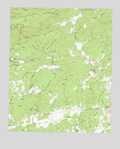
Cleveland, SC USGS Topographic Map
Click on map above to begin viewing in our Map Viewer.

This topographic map contains these locations and features:
Feature Name Type Latitude Longitude GNIS ID View Map
Allison School (historical)SchoolN35.0201°W82.5623°1245058View Map
Bald RockSummitN35.0829°W82.6215°1220306View Map
Beaverdam CreekStreamN35.0098°W82.5023°1220441View Map
Ben Hall HillSummitN35.0485°W82.5665°1231047View Map
Billingsly HillSummitN35.0118°W82.5354°1231057View Map
Blythe ShoalsRapidsN35.0704°W82.5701°1220837View Map
Caesars HeadPopulated PlaceN35.1057°W82.6235°1231116View Map
Caesars Head Post Office (historical)Post OfficeN35.1057°W82.6235°2027143View Map
Caesars Head State ParkParkN35.1043°W82.6179°1245093View Map
Camp Harris Pond Dam D-2832DamN35.0301°W82.5515°1239793View Map
Camp MariettaLocaleN35.0482°W82.5587°1221258View Map
Camp ParkerLocaleN35.0704°W82.5690°1221263View Map
Camp Stanley HarrisLocaleN35.0315°W82.5543°1221268View Map
Campbell MountainSummitN35.0946°W82.6068°1221279View Map
Civitan CampLocaleN35.0796°W82.5746°1221602View Map
ClevelandPopulated PlaceN35.0723°W82.5273°1221633View Map
Cleveland Lookout TowerTowerN35.0743°W82.5051°1242374View Map
Coldspring BranchStreamN35.1221°W82.6104°1221671View Map
Cox Camp CreekStreamN35.1243°W82.5862°1221803View Map
Cox CreekStreamN35.0868°W82.5362°1221804View Map
Devils Fork CreekStreamN35.1026°W82.5435°1247526View Map
Duck CreekStreamN35.0601°W82.5948°1247567View Map
Ehlers PondReservoirN35.0986°W82.5248°1239790View Map
Ehlers Pond DamDamN35.0979°W82.5243°2761858View Map
Ehlers Pond Dam D-1111DamN35.0935°W82.5248°1239789View Map
F Bergman Pond Dam D-1106DamN35.0235°W82.5815°1239785View Map
Falls CreekStreamN35.1232°W82.5343°1222358View Map
Freeman BridgeBridgeN35.0015°W82.5426°1247829View Map
Friendship CemeteryCemeteryN35.0171°W82.5823°1245163View Map
Friendship ChurchChurchN35.0176°W82.5821°1247845View Map
Gap CreekStreamN35.1204°W82.5376°1222639View Map
Garren LakeReservoirN35.0328°W82.6105°1222651View Map
Garren Lake Dam D-2916DamN35.0340°W82.6087°1239905View Map
Gowens CreekStreamN35.0051°W82.6018°1222790View Map
Gowens MountainSummitN35.0260°W82.6118°1231334View Map
Green MountainSummitN35.0998°W82.5801°1222876View Map
Grissom BranchStreamN35.0937°W82.5246°1222917View Map
Hall CemeteryCemeteryN35.0121°W82.5312°1222986View Map
Hardin BridgeBridgeN35.0673°W82.6182°1243376View Map
Hardin CemeteryCemeteryN35.0698°W82.6154°1223035View Map
Hart CemeteryCemeteryN35.1134°W82.5512°1223068View Map
Hawk CreekStreamN35.0040°W82.6076°1223085View Map
Holiday Lake Dam D-2207DamN35.0851°W82.5732°1239784View Map
Holly Pot Lake Dam D-2827DamN35.0885°W82.5682°1239783View Map
Jane BranchStreamN35.0998°W82.5493°1223517View Map
Little MountainSummitN35.0529°W82.5543°1224021View Map
Little Pinnacle MountainSummitN35.1193°W82.5807°1246419View Map
Lower GapGapN35.0987°W82.5835°1224210View Map
MariettaPopulated PlaceN35.0210°W82.5015°1224310View Map
Mayfield (historical)Populated PlaceN35.0187°W82.5721°1245229View Map
Mayfield BridgeBridgeN35.0173°W82.5918°1224372View Map
McDonalds PondReservoirN35.1020°W82.5252°1237515View Map
Middle River CemeteryCemeteryN35.0673°W82.5157°1245235View Map
Middle River ChurchChurchN35.0665°W82.5137°1224474View Map
Middle River School (historical)SchoolN35.0676°W82.5146°1245236View Map
Middle River School (historical)SchoolN35.0729°W82.5323°1245237View Map
Middle Saluda RiverStreamN35.0157°W82.5379°1246632View Map
Mill CreekStreamN35.0682°W82.5218°1224549View Map
Moody BridgeBridgeN35.0390°W82.5885°1224626View Map
Moody CemeteryCemeteryN35.0429°W82.5826°1224630View Map
Mountain LakeReservoirN35.0717°W82.6210°1224857View Map
Mountain Lake ColonyPopulated PlaceN35.0726°W82.6229°1231571View Map
Oil Camp CreekStreamN35.1093°W82.5473°1225164View Map
Olga (historical)Populated PlaceN35.0029°W82.5585°1243472View Map
Oolenoy RiverStreamN35.0085°W82.5926°1249985View Map
Pace BridgeBridgeN35.0123°W82.5707°1250002View Map
Persimmon RidgeRidgeN35.0914°W82.6011°1225382View Map
Phillips LakeReservoirN35.0224°W82.5926°1225403View Map
Piney MountainSummitN35.0576°W82.5493°1231666View Map
Pleasant Grove Baptist ChurchChurchN35.0287°W82.6243°1250164View Map
Pleasant Grove CemeteryCemeteryN35.0284°W82.6243°1243497View Map
Pleasant Grove School (historical)SchoolN35.0290°W82.6246°1243498View Map
Rice PondReservoirN35.0979°W82.5140°1239792View Map
Rice Pond Dam D-2831DamN35.0985°W82.5148°1239791View Map
River FallsPopulated PlaceN35.1240°W82.5418°1250392View Map
River Falls Fire Department HeadquartersBuildingN35.1198°W82.5399°2578455View Map
RiverviewPopulated PlaceN35.0912°W82.5429°1245296View Map
Robinson BranchStreamN35.0785°W82.5735°1225916View Map
Slater - Marietta Fire Department Station 1 HeadquartersBuildingN35.0267°W82.5013°2578483View Map
Slater-Marietta DivisionCivilN35.0794°W82.5855°1938424View Map
South Carolina Noname 23020 D-1095 DamDamN35.0643°W82.5685°1237501View Map
South Carolina Noname 23027 D-2830 DamDamN35.1001°W82.5248°1237514View Map
South Saluda ChurchChurchN35.0587°W82.5693°1226770View Map
Spout Spring BranchStreamN35.0451°W82.5265°1226797View Map
Tall Pine LakesReservoirN35.0641°W82.5665°1227023View Map
Talleys Mill (historical)LocaleN35.0657°W82.5732°1245617View Map
Tally BridgeBridgeN35.0673°W82.5718°1252292View Map
Tankersley LakeReservoirN35.1015°W82.5463°1227030View Map
Tankersley Lake DamDamN35.0998°W82.5476°1237497View Map
Timber Lands LakeReservoirN35.1237°W82.5222°1227143View Map
Timber Lands Lake Dam D-2829DamN35.1232°W82.5218°1239787View Map
Timmons PondReservoirN35.0230°W82.5295°1239795View Map
Timmons Pond Dam D-2833DamN35.0218°W82.5298°1239794View Map
Upper GapGapN35.0962°W82.5943°1227320View Map
Wabac Pond Dam D-3296DamN35.1218°W82.5198°1239786View Map
Watson MountainSummitN35.1098°W82.5118°1227442View Map
Wattacoo (historical)Populated PlaceN35.0607°W82.5951°1243580View Map
Wattacoo CreekStreamN35.0746°W82.5721°1251338View Map
West Fork Wattacoo CreekStreamN35.0832°W82.5801°1227490View Map
WFBC-FM (Greenville)TowerN35.1112°W82.6046°1252495View Map
Wolf CreekStreamN35.0560°W82.5257°1227679View Map
WYFF-TV (Greenville)TowerN35.1112°W82.6046°1252580View Map

Note: Coordinates in the location and feature list above are referenced to NAD83 datum.


Copyright (C) 2008-2024 Ryan Niemi / Sunset Dynamics ... All Rights Reserved