TopoQuest Logo
Do you find TopoQuest useful?
Help keep TopoQuest running and adding new maps/features by donating!
Bitcoin:  19c7KJd3qBynnjoSw5npx9KScwjBe4ifkT
Litecoin:  LXs6TkuXGGXo1vDsWCkWVdjQX94eUKd6ui
Home View Maps Find Maps Find Places Resources & Links


Climbing Hill, Iowa Topographic Map

USGS Map Title: Climbing Hill, IA
USGS Map MRC: 42096C1
DRG (GeoTIFF) Download: o42096c1.tif


Neighboring USGS Topographic Map Quads:


  Lawton, IA  
42096D2
 

  Moville, IA  
42096D1
 

  Correctionville NW, IA  
42095D8
 

  Luton, IA  
42096C2
 

  Climbing Hill, IA  
42096C1
 

  Oto, IA  
42095C8
 

  Sloan, IA  
42096B2
 

  Hornick, IA  
42096B1
 

  Smithland, IA  
42095B8


Map MRC Location:

N43°
W97°
N43°
W96°
H8 H7 H6 H5 H4 H3 H2 H1
G8 G7 G6 G5 G4 G3 G2 G1
F8 F7 F6 F5 F4 F3 F2 F1
E8 E7 E6 E5 E4 E3 E2 E1
D8 D7 D6 D5 D4 D3 D2 D1
C8 C7 C6 C5 C4 C3 C2 C1
B8 B7 B6 B5 B4 B3 B2 B1
A8 A7 A6 A5 A4 A3 A2 A1
N42°
W97°
N42°
W96°

Climbing Hill, IA USGS 1:24K Topographic Map Preview:
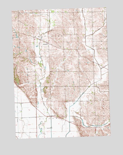
Climbing Hill, IA USGS Topographic Map
Click on map above to begin viewing in our Map Viewer.

This topographic map contains these locations and features:
Feature Name Type Latitude Longitude GNIS ID View Map
Climbing HillPopulated PlaceN42.3417°W96.0778°455477View Map
Climbing Hill CemeteryCemeteryN42.3400°W96.0772°1995678View Map
Climbing Hill Census Designated PlaceCensusN42.3394°W96.0811°2629960View Map
Climbing Hill Post Office (historical)Post OfficeN42.3417°W96.0778°1995538View Map
East Branch Wolf CreekStreamN42.3475°W96.0289°456132View Map
East Fork Wolf CreekStreamN42.3147°W96.0100°456151View Map
Garretson DitchCanalN42.2728°W96.1217°456849View Map
German City CemeteryCemeteryN42.2696°W96.0479°1995677View Map
German City ChurchChurchN42.2694°W96.0478°456881View Map
German City Post Office (historical)Post OfficeN42.2680°W96.0461°1995539View Map
Holly SpringsPopulated PlaceN42.2705°W96.0778°457562View Map
Holly Springs Post Office (historical)Post OfficeN42.2705°W96.0778°1995540View Map
Lum Hollow CreekStreamN42.2703°W96.0533°458680View Map
Moose CreekStreamN42.2636°W96.0014°459220View Map
PieroLocaleN42.3394°W96.0195°466262View Map
Snyder's Grove Post Office (historical)Post OfficeN42.3000°W96.1184°1995517View Map
Township of West ForkCivilN42.3429°W96.0770°468979View Map
Township of WillowCivilN42.2562°W96.0774°469006View Map
Willow CemeteryCemeteryN42.2705°W96.0593°463071View Map
Wolf Creek Drainage DitchCanalN42.2667°W96.0536°463298View Map
Woodbury County Disaster and Emergency ServicesBuildingN42.3425°W96.0790°2599907View Map

Note: Coordinates in the location and feature list above are referenced to NAD83 datum.


Copyright (C) 2008-2024 Ryan Niemi / Sunset Dynamics ... All Rights Reserved