TopoQuest Logo
Do you find TopoQuest useful?
Help keep TopoQuest running and adding new maps/features by donating!
Bitcoin:  19c7KJd3qBynnjoSw5npx9KScwjBe4ifkT
Litecoin:  LXs6TkuXGGXo1vDsWCkWVdjQX94eUKd6ui
Home View Maps Find Maps Find Places Resources & Links


Colcord NE, Arkansas Topographic Map

USGS Map Title: Colcord NE, AR
USGS Map MRC: 36094D5
DRG (GeoTIFF) Download: o36094d5.tif


Neighboring USGS Topographic Map Quads:


  Dodge, OK  
36094E6
 

  South West City, MO  
36094E5
 

  Noel, MO  
36094E4
 

  Sycamore, OK  
36094D6
 

  Colcord NE, AR  
36094D5
 

  Gravette, AR  
36094D4
 

  Colcord, OK  
36094C6
 

  Cherokee City, AR  
36094C5
 

  Gentry, AR  
36094C4


Map MRC Location:

N37°
W95°
N37°
W94°
H8 H7 H6 H5 H4 H3 H2 H1
G8 G7 G6 G5 G4 G3 G2 G1
F8 F7 F6 F5 F4 F3 F2 F1
E8 E7 E6 E5 E4 E3 E2 E1
D8 D7 D6 D5 D4 D3 D2 D1
C8 C7 C6 C5 C4 C3 C2 C1
B8 B7 B6 B5 B4 B3 B2 B1
A8 A7 A6 A5 A4 A3 A2 A1
N36°
W95°
N36°
W94°

Colcord NE, AR USGS 1:24K Topographic Map Preview:
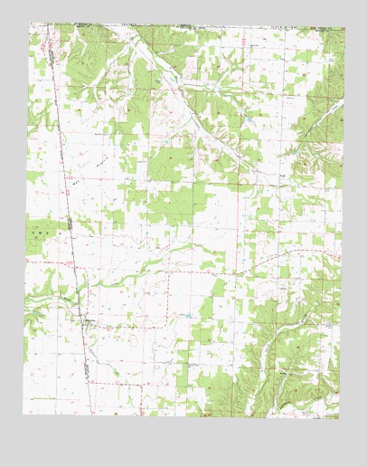
Colcord NE, AR USGS Topographic Map
Click on map above to begin viewing in our Map Viewer.

This topographic map contains these locations and features:
Feature Name Type Latitude Longitude GNIS ID View Map
Appleglen DairyLocaleN36.4517°W94.5786°2709208View Map
Batson PrairieAreaN36.4065°W94.5419°75375View Map
Beatie PrairieAreaN36.4209°W94.5683°75377View Map
Beatie Prairie School (historical)SchoolN36.4215°W94.5677°75378View Map
BeatyPopulated PlaceN36.4515°W94.5252°56921View Map
Camden FarmLocaleN36.4672°W94.5964°2709211View Map
Cave (historical)Populated PlaceN36.4106°W94.5863°75420View Map
Chalybeate CreekStreamN36.4759°W94.5002°76582View Map
Checks Corner (historical)Populated PlaceN36.4892°W94.5241°75430View Map
Crump (historical)Populated PlaceN36.4895°W94.5061°75505View Map
Dow CemeteryCemeteryN36.4164°W94.5251°48591View Map
Everlasting FarmsLocaleN36.3939°W94.5631°2709216View Map
Georgia CemeteryCemeteryN36.4048°W94.5030°49380View Map
Jaybird (historical)Populated PlaceN36.3848°W94.5647°75567View Map
Jaybird Church (historical)ChurchN36.3826°W94.5644°75568View Map
Jaybird School (historical)SchoolN36.3826°W94.5644°75569View Map
Lee (historical)Populated PlaceN36.4781°W94.5244°75581View Map
Lee CemeteryCemeteryN36.4781°W94.5238°77465View Map
Lee Church (historical)ChurchN36.4784°W94.5247°75582View Map
Lee School (historical)SchoolN36.4784°W94.5241°75583View Map
MaysvillePopulated PlaceN36.4037°W94.6019°77622View Map
Maysville CemeteryCemeteryN36.4153°W94.5977°75909View Map
Maysville Census Designated PlaceCensusN36.4019°W94.5889°2582918View Map
Maysville Fire StationBuildingN36.4051°W94.6023°2116776View Map
Maysville Post OfficePost OfficeN36.4034°W94.6018°84616View Map
Maysville School (historical)SchoolN36.4084°W94.6005°75910View Map
Miller Springs (historical)Populated PlaceN36.4754°W94.5630°75919View Map
Moses Fields CemeteryCemeteryN36.4050°W94.6049°2723926View Map
Mount Zion Baptist ChurchChurchN36.4937°W94.5380°77761View Map
Mount Zion School (historical)SchoolN36.4934°W94.5380°75926View Map
Pleasant Center ChurchChurchN36.3917°W94.5608°53521View Map
Rome City (historical)Populated PlaceN36.3945°W94.6008°75432View Map
Shady Grove School (historical)SchoolN36.4129°W94.5169°76015View Map
T K FarmsLocaleN36.4636°W94.6047°2709220View Map
Town CreekStreamN36.4120°W94.6099°55621View Map
Township of Apple Glenn (historical)CivilN36.4501°W94.5336°69572View Map
Township of Beatie (historical)CivilN36.4376°W94.5877°69574View Map
Wann (historical)Populated PlaceN36.4829°W94.5630°76083View Map
Wann Baptist Church (historical)ChurchN36.4831°W94.5630°76084View Map
Wann CemeteryCemeteryN36.4817°W94.5723°56031View Map
Wann School (historical)SchoolN36.4831°W94.5630°76085View Map
Ward CemeteryCemeteryN36.3765°W94.5127°78693View Map
Wet Prairie CemeteryCemeteryN36.4648°W94.5933°56214View Map
Wet Prairie Church (historical)ChurchN36.4645°W94.5924°76092View Map
Wet Prairie School (historical)SchoolN36.4645°W94.5919°76093View Map

Note: Coordinates in the location and feature list above are referenced to NAD83 datum.


Copyright (C) 2008-2024 Ryan Niemi / Sunset Dynamics ... All Rights Reserved