TopoQuest Logo
Do you find TopoQuest useful?
Help keep TopoQuest running and adding new maps/features by donating!
Bitcoin:  19c7KJd3qBynnjoSw5npx9KScwjBe4ifkT
Litecoin:  LXs6TkuXGGXo1vDsWCkWVdjQX94eUKd6ui
Home View Maps Find Maps Find Places Resources & Links


Cross Lake, Minnesota Topographic Map

USGS Map Title: Cross Lake, MN
USGS Map MRC: 46094F1
DRG (GeoTIFF) Download: o46094f1.tif


Neighboring USGS Topographic Map Quads:


  Stewart Lake, MN  
46094G2
 

  Mitchell Lake, MN  
46094G1
 

  Roosevelt Lake, MN  
46093G8
 

  Lower Whitefish Lake, MN  
46094F2
 

  Cross Lake, MN  
46094F1
 

  Emily, MN  
46093F8
 

  Pelican Lake, MN  
46094E2
 

  Trommald, MN  
46094E1
 

  Cuyuna, MN  
46093E8


Map MRC Location:

N47°
W95°
N47°
W94°
H8 H7 H6 H5 H4 H3 H2 H1
G8 G7 G6 G5 G4 G3 G2 G1
F8 F7 F6 F5 F4 F3 F2 F1
E8 E7 E6 E5 E4 E3 E2 E1
D8 D7 D6 D5 D4 D3 D2 D1
C8 C7 C6 C5 C4 C3 C2 C1
B8 B7 B6 B5 B4 B3 B2 B1
A8 A7 A6 A5 A4 A3 A2 A1
N46°
W95°
N46°
W94°

Cross Lake, MN USGS 1:24K Topographic Map Preview:
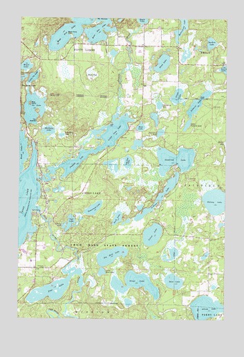
Cross Lake, MN USGS Topographic Map
Click on map above to begin viewing in our Map Viewer.

This topographic map contains these locations and features:
Feature Name Type Latitude Longitude GNIS ID View Map
Adney LakeLakeN46.6299°W94.0111°639216View Map
Bass LakeLakeN46.6406°W94.0309°639692View Map
Bass LakeLakeN46.7045°W94.0522°639697View Map
Berg IslandIslandN46.7144°W94.1191°639951View Map
Big Bird LakeLakeN46.6511°W94.0693°640080View Map
Big BogSwampN46.7272°W94.0822°640081View Map
Black PointCapeN46.7436°W94.0961°640225View Map
Buchite LakeLakeN46.7398°W94.0098°640577View Map
Caressant HouseHospitalN46.6667°W94.1111°2071737View Map
City of CrosslakeCivilN46.6756°W94.0955°2393681View Map
City of Fifty Lakes Fire DepartmentBuildingN46.7367°W94.0502°2666684View Map
Command LakeLakeN46.7023°W94.0400°641420View Map
Cook PointCapeN46.7172°W94.0166°641458View Map
Cranberry LakeLakeN46.7012°W94.0999°642419View Map
Cranberry LakeLakeN46.7140°W94.0409°642420View Map
Cross LakePopulated PlaceN46.6594°W94.1139°642486View Map
Cross Lake SchoolSchoolN46.6733°W94.1080°642491View Map
Crosslake Area Historical Society / Historical Log VillageLocaleN46.6833°W94.1111°2071738View Map
Crosslake City HallBuildingN46.6889°W94.1125°2071743View Map
Crosslake Evangelical Free ChurchChurchN46.6925°W94.1125°2071744View Map
Crosslake Fire DepartmentBuildingN46.6898°W94.1134°2071742View Map
Crosslake Police DepartmentBuildingN46.6898°W94.1134°2071741View Map
Crosslake Post OfficePost OfficeN46.6732°W94.1081°662869View Map
Crosslake Presbyterian ChurchChurchN46.6964°W94.1139°2071745View Map
Crossroads Christian Assembly ChurchChurchN46.6800°W94.1111°2071739View Map
Crossroads Golf CourseLocaleN46.6756°W94.1056°2071755View Map
Daggett CreekStreamN46.7102°W94.0658°642583View Map
Daggett LakeLakeN46.6894°W94.0933°642584View Map
Davis LakeLakeN46.7283°W94.0002°642653View Map
Dolney LakeLakeN46.6742°W94.0059°659753View Map
Eagle Lake DamDamN46.7466°W94.0519°1775958View Map
East Fox LakeLakeN46.7449°W94.0781°656094View Map
Fern LakeLakeN46.6635°W94.0977°643611View Map
Fifty LakesPopulated PlaceN46.7391°W94.0930°643626View Map
Fifty Lakes City HallBuildingN46.7392°W94.0928°2071762View Map
Fifty Lakes Daggett Brook CampgroundLocaleN46.7392°W94.0578°2071764View Map
Fifty Lakes Post OfficePost OfficeN46.7383°W94.0511°662870View Map
Four Acre LakeLakeN46.7251°W94.1226°643844View Map
Fox CreekStreamN46.7275°W94.0630°643858View Map
Golden Rule Trailer ParkPopulated PlaceN46.6667°W94.1111°2071736View Map
Goodrich LakeLakeN46.6913°W94.0310°644224View Map
Grass LakeLakeN46.7178°W94.0300°644380View Map
Greer LakeReservoirN46.6396°W94.0541°1775961View Map
Greer Lake DamDamN46.6350°W94.0653°1775960View Map
Immaculate Heart Catholic ChurchChurchN46.6806°W94.1111°2071740View Map
Lily Pad LakeLakeN46.6902°W94.0596°646654View Map
Little Bird LakeLakeN46.6444°W94.0745°646764View Map
Little Ox LakeLakeN46.7249°W94.1178°646876View Map
Little Pickerel LakeLakeN46.7057°W94.0239°646883View Map
Little Pine LakeLakeN46.7028°W94.0700°646887View Map
McClain LakeLakeN46.7031°W94.1075°647660View Map
Meyer LakeLakeN46.7296°W94.1221°647789View Map
Mission of the Cross Lutheran ChurchChurchN46.6461°W94.1144°2071746View Map
O'Brien LakeLakeN46.6761°W94.0398°648780View Map
Ox LakeLakeN46.7123°W94.1171°649097View Map
Phelps LakeReservoirN46.6566°W94.0503°1775963View Map
Pickerel LakeLakeN46.7144°W94.0180°649371View Map
Pine LakeLakeN46.6376°W94.1028°649479View Map
Pine River DamDamN46.6683°W94.1119°1776802View Map
Pine River ReservoirReservoirN46.6683°W94.1119°1776803View Map
Pinewood CemeteryCemeteryN46.6463°W94.1091°649507View Map
Rock LakeLakeN46.6668°W94.0655°650199View Map
Sand LakeLakeN46.7314°W94.0392°651157View Map
Tamarack LakeLakeN46.6707°W94.0799°653011View Map
The NarrowsChannelN46.7500°W94.0775°658646View Map
The NeedlesPillarN46.7072°W94.1150°653116View Map
Tiff LakeLakeN46.6649°W94.0939°653197View Map
Velvet Beach Park CampgroundLocaleN46.6644°W94.0472°2071470View Map
Velvet LakeLakeN46.6600°W94.0441°653624View Map
Velvet Lake DamDamN46.6566°W94.0503°1775962View Map
West Fox LakeLakeN46.7453°W94.0940°658952View Map

Note: Coordinates in the location and feature list above are referenced to NAD83 datum.


Copyright (C) 2008-2024 Ryan Niemi / Sunset Dynamics ... All Rights Reserved