TopoQuest Logo
Do you find TopoQuest useful?
Help keep TopoQuest running and adding new maps/features by donating!
Bitcoin:  19c7KJd3qBynnjoSw5npx9KScwjBe4ifkT
Litecoin:  LXs6TkuXGGXo1vDsWCkWVdjQX94eUKd6ui
Home View Maps Find Maps Find Places Resources & Links


Davenport West, Iowa Topographic Map

USGS Map Title: Davenport West, IA
USGS Map MRC: 41090E6
DRG (GeoTIFF) Download: o41090e6.tif


Neighboring USGS Topographic Map Quads:


  Dixon, IA  
41090F7
 

  Donahue, IA  
41090F6
 

  Eldridge, IA  
41090F5
 

  Walcott, IA  
41090E7
 

  Davenport West, IA  
41090E6
 

  Davenport East, IA  
41090E5
 

  Montpelier, IA  
41090D7
 

  Andalusia, IL  
41090D6
 

  Milan, IL  
41090D5


Map MRC Location:

N42°
W91°
N42°
W90°
H8 H7 H6 H5 H4 H3 H2 H1
G8 G7 G6 G5 G4 G3 G2 G1
F8 F7 F6 F5 F4 F3 F2 F1
E8 E7 E6 E5 E4 E3 E2 E1
D8 D7 D6 D5 D4 D3 D2 D1
C8 C7 C6 C5 C4 C3 C2 C1
B8 B7 B6 B5 B4 B3 B2 B1
A8 A7 A6 A5 A4 A3 A2 A1
N41°
W91°
N41°
W90°

Davenport West, IA USGS 1:24K Topographic Map Preview:
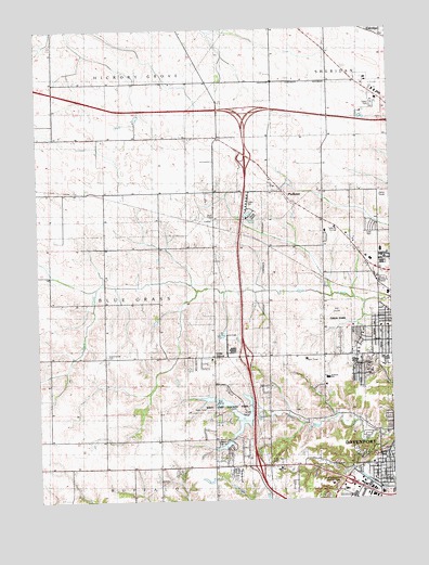
Davenport West, IA USGS Topographic Map
Click on map above to begin viewing in our Map Viewer.

This topographic map contains these locations and features:
Feature Name Type Latitude Longitude GNIS ID View Map
Black HawkPopulated PlaceN41.5209°W90.6376°464237View Map
Buchanan Elementary SchoolSchoolN41.5661°W90.6285°2046366View Map
Cardinal CreekStreamN41.5539°W90.6461°2093132View Map
Central Park ChurchChurchN41.5459°W90.6260°464905View Map
Christ ChapelChurchN41.5095°W90.6260°2046330View Map
Church of Latter Day SaintsChurchN41.5500°W90.6274°2046343View Map
Crystal CreekStreamN41.5522°W90.6342°2127000View Map
Davenport Seventh Day Adventist ChurchChurchN41.5684°W90.6382°2046320View Map
Emeis Golf CourseLocaleN41.5500°W90.6446°2046357View Map
Emeis ParkParkN41.5473°W90.6446°2046358View Map
Fairmont CemeteryCemeteryN41.5122°W90.6374°465074View Map
Fairview School (historical)SchoolN41.6114°W90.6896°465077View Map
Friday Family CemeteryCemeteryN41.5096°W90.6679°456777View Map
Grace ChurchChurchN41.5156°W90.6771°464903View Map
Grandview TerraceHospitalN41.5039°W90.6471°2046294View Map
Heritage Free Will Baptist ChurchChurchN41.5350°W90.6679°2046353View Map
Hickory Grove Mobile Home ParkPopulated PlaceN41.5584°W90.6279°2046365View Map
Hillcrest ChurchChurchN41.5086°W90.6643°464900View Map
Hometown Lakeside Mobile Home ParkPopulated PlaceN41.5070°W90.6807°2046369View Map
Husam Post Office (historical)Post OfficeN41.5459°W90.6974°2046250View Map
I-280 LakeReservoirN41.5215°W90.6781°463443View Map
I-280 Lake DamDamN41.5234°W90.6743°463442View Map
Immanuel ChurchChurchN41.5095°W90.6307°464902View Map
Interchange 1CrossingN41.5917°W90.6751°2046601View Map
Interchange 290CrossingN41.6028°W90.6751°2047400View Map
Interchange 4CrossingN41.5381°W90.6765°2046600View Map
Interchange 6CrossingN41.5089°W90.6724°2046599View Map
Interstate RV Park and CampgroundLocaleN41.6050°W90.6307°2046276View Map
Jackson Elementary SchoolSchoolN41.5324°W90.6482°464909View Map
Kisenmacher CemeteryCemeteryN41.5381°W90.7263°458114View Map
Lake Canyada Mobile Home ParkPopulated PlaceN41.5125°W90.6835°2046370View Map
Lakeside Manor CampgroundLocaleN41.5089°W90.6807°2046264View Map
Lakewood ParkPopulated PlaceN41.5792°W90.6765°2046364View Map
Little GrovesPopulated PlaceN41.5375°W90.6888°464623View Map
Marantha Church of GodChurchN41.5089°W90.6318°2046331View Map
Meadow Lawn Nursing CenterHospitalN41.5703°W90.6379°2046285View Map
Northeast LakeReservoirN41.5269°W90.6761°463502View Map
Northeast Lake DamDamN41.5267°W90.6768°463503View Map
Ponderosa Park Mobile Home ParkPopulated PlaceN41.5161°W90.6349°2046368View Map
ProbsteiPopulated PlaceN41.5814°W90.6626°460457View Map
Probstei School (historical)SchoolN41.5745°W90.6507°465144View Map
Quad City Seventh-Day Adventist Junior AcademySchoolN41.5688°W90.6382°2719760View Map
Royal Neighbors HomeHospitalN41.5039°W90.6471°2046293View Map
Saint Albans ChurchChurchN41.5459°W90.6285°464906View Map
Southwest ParkParkN41.5125°W90.6458°2084097View Map
Sovereign Grace ChurchChurchN41.5361°W90.6482°464901View Map
Streetfire Gospel ChurchChurchN41.5378°W90.6479°464907View Map
Teds Mobile Home ParkPopulated PlaceN41.5375°W90.6335°2046367View Map
The Church of Jesus Christ of Latter Day SaintsChurchN41.5714°W90.6479°2046326View Map
The Midwest Center for Safety and Rescue TrainingBuildingN41.6029°W90.6335°2599695View Map
Township of Blue GrassCivilN41.5516°W90.7315°467468View Map
Tri - City Jewish CemeteryCemeteryN41.5120°W90.6310°464908View Map
Vietnamese Baptist ChurchChurchN41.5378°W90.6490°2046325View Map
Wacky Waters ParkParkN41.5186°W90.6335°464899View Map
Walnut Hill School (historical)SchoolN41.5086°W90.6401°465178View Map
West High SchoolSchoolN41.5367°W90.6274°462865View Map
West Lake County ParkParkN41.5242°W90.6813°464898View Map
West Park ChurchChurchN41.5373°W90.6354°464904View Map
Westside Assembly of God ChurchChurchN41.5042°W90.6368°2046344View Map
Wood Dale Mobile Home ParkPopulated PlaceN41.5098°W90.6638°2046363View Map

Note: Coordinates in the location and feature list above are referenced to NAD83 datum.


Copyright (C) 2008-2024 Ryan Niemi / Sunset Dynamics ... All Rights Reserved