TopoQuest Logo
Do you find TopoQuest useful?
Help keep TopoQuest running and adding new maps/features by donating!
Bitcoin:  19c7KJd3qBynnjoSw5npx9KScwjBe4ifkT
Litecoin:  LXs6TkuXGGXo1vDsWCkWVdjQX94eUKd6ui
Home View Maps Find Maps Find Places Resources & Links


Andalusia, Illinois Topographic Map

USGS Map Title: Andalusia, IL
USGS Map MRC: 41090D6
DRG (GeoTIFF) Download: o41090d6.tif


Neighboring USGS Topographic Map Quads:


  Walcott, IA  
41090E7
 

  Davenport West, IA  
41090E6
 

  Davenport East, IA  
41090E5
 

  Montpelier, IA  
41090D7
 

  Andalusia, IL  
41090D6
 

  Milan, IL  
41090D5
 

  Buffalo Prairie, IL  
41090C7
 

  Reynolds, IL  
41090C6
 

  Matherville, IL  
41090C5


Map MRC Location:

N42°
W91°
N42°
W90°
H8 H7 H6 H5 H4 H3 H2 H1
G8 G7 G6 G5 G4 G3 G2 G1
F8 F7 F6 F5 F4 F3 F2 F1
E8 E7 E6 E5 E4 E3 E2 E1
D8 D7 D6 D5 D4 D3 D2 D1
C8 C7 C6 C5 C4 C3 C2 C1
B8 B7 B6 B5 B4 B3 B2 B1
A8 A7 A6 A5 A4 A3 A2 A1
N41°
W91°
N41°
W90°

Andalusia, IL USGS 1:24K Topographic Map Preview:
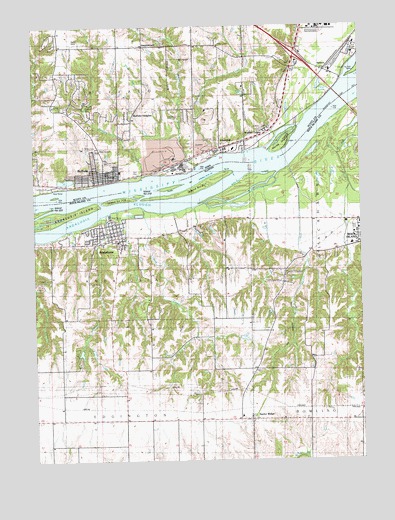
Andalusia, IL USGS Topographic Map
Click on map above to begin viewing in our Map Viewer.

This topographic map contains these locations and features:
Feature Name Type Latitude Longitude GNIS ID View Map
AndalusiaPopulated PlaceN41.4392°W90.7176°403496View Map
Andalusia CemeteryCemeteryN41.4361°W90.7174°403497View Map
Andalusia Community Baptist ChurchChurchN41.4425°W90.7168°2042561View Map
Andalusia Elementary SchoolSchoolN41.4381°W90.7179°2042119View Map
Andalusia Fire Protection District Station 1BuildingN41.4426°W90.7205°2640260View Map
Andalusia Post OfficePost OfficeN41.4432°W90.7190°2788456View Map
Andalusia Volunteer Ambulance ServiceBuildingN41.4385°W90.7213°2673869View Map
Army Ridge BluffsSummitN41.4331°W90.6499°1725353View Map
Asbury School (historical)SchoolN41.4942°W90.6838°465054View Map
Black Hawk School (historical)SchoolN41.4298°W90.6529°424021View Map
Black Oak School (historical)SchoolN41.4303°W90.6776°424022View Map
BuffaloPopulated PlaceN41.4564°W90.7235°454951View Map
BuffaloLocaleN41.4556°W90.7210°2046555View Map
Buffalo City HallBuildingN41.4573°W90.7218°2046562View Map
Buffalo City ParkParkN41.4584°W90.7163°2046560View Map
Buffalo Civic CenterBuildingN41.4586°W90.7210°2046559View Map
Buffalo Elementary SchoolSchoolN41.4627°W90.7250°2046557View Map
Buffalo Fire DepartmentBuildingN41.4567°W90.7164°2046561View Map
Buffalo Friends ChurchChurchN41.4575°W90.7190°2046553View Map
Buffalo HeightsPopulated PlaceN41.4725°W90.7146°454965View Map
Buffalo Post OfficePost OfficeN41.4559°W90.7213°2046556View Map
Buffalo Station LibraryBuildingN41.4586°W90.7210°2046558View Map
Buffalo Volunteer Ambulance ServiceBuildingN41.4567°W90.7164°2599882View Map
Calvary Lutheran ChurchChurchN41.4586°W90.7221°2046552View Map
Carp LakeLakeN41.4827°W90.6404°455179View Map
Chapel Hill (historical)Populated PlaceN41.4923°W90.6474°465063View Map
Chapel Hill CemeteryCemeteryN41.4941°W90.6783°454249View Map
City of BuffaloCivilN41.4648°W90.6982°2393454View Map
Colony SchoolSchoolN41.4934°W90.7404°455539View Map
Coon Hunters Club (historical)LocaleN41.4870°W90.7421°465660View Map
Curry School (historical)SchoolN41.3936°W90.6454°424032View Map
Dodges CreekStreamN41.4564°W90.7088°455935View Map
Donaldson CreekStreamN41.4628°W90.6810°455951View Map
Edgington Center School (historical)SchoolN41.3870°W90.7260°424035View Map
Excelsior School (historical)SchoolN41.3906°W90.6874°424039View Map
Fancy CreekStreamN41.4470°W90.7079°408262View Map
Harbor Road School (historical)SchoolN41.4734°W90.6496°465091View Map
Hidden LakeReservoirN41.4060°W90.7325°1691967View Map
Hidden Lake DamDamN41.4067°W90.7318°1691966View Map
Hills CreekStreamN41.4448°W90.7238°410284View Map
HM Perry SchoolSchoolN41.4895°W90.6493°457191View Map
Horse IslandIslandN41.4667°W90.6538°457665View Map
Interchange 8CrossingN41.4917°W90.6501°2046598View Map
Island Number 317IslandN41.4528°W90.6890°425044View Map
Island Number 318IslandN41.4514°W90.7096°425045View Map
Island Number 319IslandN41.4500°W90.7179°425046View Map
JamestownPopulated PlaceN41.4945°W90.7082°464593View Map
Jamestown Post Office (historical)Post OfficeN41.4945°W90.7082°2046257View Map
Kickapoo SloughStreamN41.4630°W90.6338°411451View Map
Lake VelraLakeN41.4289°W90.6600°1748080View Map
Landmark Missionary Baptist ChurchChurchN41.4645°W90.7274°2046554View Map
LinwoodPopulated PlaceN41.4656°W90.6790°458423View Map
Marietta ParkParkN41.4596°W90.7164°2084096View Map
Mill CreekStreamN41.4714°W90.6376°413543View Map
Moore CreekStreamN41.4598°W90.6882°459210View Map
NahantPopulated PlaceN41.4875°W90.6379°464663View Map
Nahant MarshSwampN41.4912°W90.6375°2084098View Map
Nahant Marsh Outdoor Education and Research CenterBuildingN41.4872°W90.6362°2084099View Map
Perry Elementary SchoolSchoolN41.4898°W90.6485°2046362View Map
Rockingham (historical)Populated PlaceN41.4825°W90.6335°465341View Map
Rockingham Post Office (historical)Post OfficeN41.4825°W90.6335°2046254View Map
Rose Hill CemeteryCemeteryN41.4645°W90.7257°460791View Map
Saint Peter Catholic ChurchChurchN41.4586°W90.7215°2046551View Map
Saint Peter's CemeteryCemeteryN41.4648°W90.7265°2047401View Map
Swift SloughGutN41.4508°W90.6711°2747104View Map
Taylor RidgePopulated PlaceN41.3867°W90.6682°419567View Map
Taylor Ridge Elementary SchoolSchoolN41.3878°W90.6715°2042123View Map
Taylor Ridge Post OfficePost OfficeN41.3866°W90.6677°2788288View Map
Taylor Ridge United Methodist ChurchChurchN41.3875°W90.6682°2042565View Map
Township of AndalusiaCivilN41.4350°W90.7211°428590View Map
Township of BuffaloCivilN41.4808°W90.7294°467504View Map
Turkey Hollow CreekStreamN41.4528°W90.6640°419931View Map
Turkey Hollow DamDamN41.4100°W90.6718°1691962View Map
Turkey Hollow ReservoirReservoirN41.4101°W90.6702°1691963View Map
Village of AndalusiaCivilN41.4374°W90.7164°2397960View Map
Walnut GrovePopulated PlaceN41.4703°W90.6613°462643View Map
Watts LandfillLocaleN41.4381°W90.6792°2680844View Map
White Sulphur (historical)LocaleN41.4650°W90.6779°2046256View Map
White Sulphur Post Office (historical)Post OfficeN41.4650°W90.6779°2046255View Map

Note: Coordinates in the location and feature list above are referenced to NAD83 datum.


Copyright (C) 2008-2024 Ryan Niemi / Sunset Dynamics ... All Rights Reserved