TopoQuest Logo
Do you find TopoQuest useful?
Help keep TopoQuest running and adding new maps/features by donating!
Bitcoin:  19c7KJd3qBynnjoSw5npx9KScwjBe4ifkT
Litecoin:  LXs6TkuXGGXo1vDsWCkWVdjQX94eUKd6ui
Home View Maps Find Maps Find Places Resources & Links


Dellrose, Tennessee Topographic Map

USGS Map Title: Dellrose, TN
USGS Map MRC: 35086A7
DRG (GeoTIFF) Download: o35086a7.tif


Neighboring USGS Topographic Map Quads:


  Tarpley, TN  
35086B8
 

  Frankewing, TN  
35086B7
 

  Boonshill, TN  
35086B6
 

  Elkton, TN  
35086A8
 

  Dellrose, TN  
35086A7
 

  Taft, TN  
35086A6
 

  Elkmont, AL  
34086H8
 

  Ardmore, AL  
34086H7
 

  Toney, AL  
34086H6


Map MRC Location:

N36°
W87°
N36°
W86°
H8 H7 H6 H5 H4 H3 H2 H1
G8 G7 G6 G5 G4 G3 G2 G1
F8 F7 F6 F5 F4 F3 F2 F1
E8 E7 E6 E5 E4 E3 E2 E1
D8 D7 D6 D5 D4 D3 D2 D1
C8 C7 C6 C5 C4 C3 C2 C1
B8 B7 B6 B5 B4 B3 B2 B1
A8 A7 A6 A5 A4 A3 A2 A1
N35°
W87°
N35°
W86°

Dellrose, TN USGS 1:24K Topographic Map Preview:
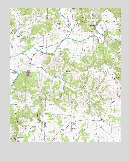
Dellrose, TN USGS Topographic Map
Click on map above to begin viewing in our Map Viewer.

This topographic map contains these locations and features:
Feature Name Type Latitude Longitude GNIS ID View Map
Anderson CemeteryCemeteryN35.0512°W86.8228°1645162View Map
BaughPopulated PlaceN35.0731°W86.8506°1276490View Map
Bee Spring BranchStreamN35.1070°W86.8642°1276781View Map
Bee Spring Memorial ChurchChurchN35.0981°W86.8625°1276784View Map
Beech HollowValleyN35.0381°W86.8495°1276845View Map
Bethany ChurchChurchN35.0976°W86.8608°1277079View Map
BlanchePopulated PlaceN35.0431°W86.7544°1305285View Map
Blanche CemeteryCemeteryN35.1217°W86.7597°1645355View Map
Blanche Chapel SchoolSchoolN35.0629°W86.7600°1277657View Map
Blanche SchoolSchoolN35.0381°W86.7581°1316180View Map
Blanche Volunteer Fire RescueBuildingN35.0378°W86.7586°2654039View Map
Bledsoe CemeteryCemeteryN35.0395°W86.8247°1277678View Map
Bledsoe HollowValleyN35.0528°W86.8148°1277682View Map
Blindman HollowValleyN35.0438°W86.7754°1277695View Map
Boswell CemeteryCemeteryN35.0215°W86.8603°1278020View Map
Bradshaw CreekStreamN35.0967°W86.8094°1278199View Map
Brown BranchStreamN35.1001°W86.8694°1278512View Map
Bruce CemeteryCemeteryN35.1120°W86.8114°1645184View Map
BrysonPopulated PlaceN35.0987°W86.8617°1314754View Map
C and C FarmLocaleN35.0328°W86.7536°2724547View Map
Cash PointPopulated PlaceN35.0181°W86.8053°1279848View Map
Cash Point Baptist ChurchChurchN35.0173°W86.8050°1643955View Map
Cash Point School (historical)SchoolN35.0162°W86.8042°1316184View Map
Cheatham BendBendN35.1054°W86.7711°1280303View Map
Circle P FarmsLocaleN35.0172°W86.7533°2724556View Map
City of ArdmoreCivilN35.0032°W86.8556°2403110View Map
Corpier CemeteryCemeteryN35.0248°W86.8239°1281328View Map
Cross CemeteryCemeteryN35.0306°W86.7767°1306190View Map
Crowley IslandIslandN35.0895°W86.8206°1310342View Map
DellrosePopulated PlaceN35.1131°W86.8014°1306325View Map
Dellrose Post OfficePost OfficeN35.1092°W86.8094°1650322View Map
Dellrose SchoolSchoolN35.1170°W86.7936°1282322View Map
Dellrose Volunteer Fire RescueBuildingN35.1094°W86.8092°2653847View Map
Dollar SpringSpringN35.1154°W86.7939°1282625View Map
Eagin CemeteryCemeteryN35.0812°W86.8478°1283283View Map
Elkmont SpringsSpringN35.0085°W86.8665°1650366View Map
Elkmont SpringsPopulated PlaceN35.0051°W86.8669°1283658View Map
Elkton Division (historical)CensusN35.0476°W86.8714°1648707View Map
Ewing CemeteryCemeteryN35.0509°W86.7969°1645212View Map
Ezell CemeteryCemeteryN35.0073°W86.8728°1283950View Map
Falls HollowValleyN35.0349°W86.8703°1284110View Map
Farrar CemeteryCemeteryN35.1173°W86.7644°1645214View Map
Franklin CemeteryCemeteryN35.0042°W86.8033°1284818View Map
Gatlin CemeteryCemeteryN35.0131°W86.8050°1285245View Map
George CemeteryCemeteryN35.1004°W86.7967°1285290View Map
Gum SpringSpringN35.1056°W86.8181°1286415View Map
Hamilton MillPopulated PlaceN35.1087°W86.7789°1315183View Map
Indian CreekStreamN35.0792°W86.8733°1288957View Map
Indian Creek CemeteryCemeteryN35.1037°W86.8711°1644001View Map
Indian Creek Church (historical)ChurchN35.1031°W86.8706°1316278View Map
Indian Creek SchoolSchoolN35.1031°W86.8700°1288978View Map
Kelly CreekStreamN35.0823°W86.8597°1290030View Map
Kelly Creek ChurchChurchN35.0215°W86.7711°1290033View Map
Kelly Creek ChurchChurchN35.0604°W86.8200°1290034View Map
King BranchStreamN35.0920°W86.8739°1290193View Map
Lake LoganReservoirN35.0636°W86.8543°1301537View Map
Lake Logan DamDamN35.0651°W86.8550°1301536View Map
Lewter CemeteryCemeteryN35.0179°W86.8406°1291097View Map
Lewter HollowValleyN35.0278°W86.8437°1291099View Map
Luda SidingLocaleN35.0418°W86.8417°1316281View Map
Luda TunnelTunnelN35.0393°W86.8408°1316282View Map
Maddox BranchStreamN35.0912°W86.7731°1292471View Map
Maddox CemeteryCemeteryN35.0351°W86.8500°1292472View Map
Major CemeteryCemeteryN35.0795°W86.8047°1292519View Map
Malone CemeteryCemeteryN35.0351°W86.8264°1292536View Map
McKinney HollowValleyN35.0655°W86.8124°1293381View Map
Meetinghouse HillSummitN35.0837°W86.8122°1293544View Map
Merrell CemeteryCemeteryN35.0467°W86.7878°1293625View Map
Metcalf CemeteryCemeteryN35.1245°W86.7717°1645285View Map
Millville HollowValleyN35.1180°W86.8037°1312899View Map
Mitchell BendBendN35.0956°W86.7717°1294092View Map
Mitchell Spring BranchStreamN35.1131°W86.8656°1310385View Map
Morrell MillPopulated PlaceN35.0776°W86.8725°1294407View Map
New DellrosePopulated PlaceN35.1095°W86.8092°1295471View Map
New Grove CemeteryCemeteryN35.0648°W86.7786°1645292View Map
New Grove ChurchChurchN35.0656°W86.7778°1295486View Map
O'Neal BranchStreamN35.0870°W86.8214°1296040View Map
Oliver SpringSpringN35.1120°W86.7894°1296422View Map
Oliver Spring BranchStreamN35.1051°W86.8044°1296423View Map
Patterson BranchStreamN35.0940°W86.7939°1296923View Map
Patterson CemeteryCemeteryN35.0926°W86.7911°1296935View Map
Persimmon IslandIslandN35.0645°W86.8661°1297230View Map
Reed BranchStreamN35.0559°W86.8125°1299117View Map
Rogers HillSummitN35.0448°W86.8281°1300017View Map
Roper CemeteryCemeteryN35.0212°W86.7706°1645356View Map
Roper SpringSpringN35.0124°W86.7937°1300055View Map
Rowe BranchStreamN35.1029°W86.8067°1300196View Map
Short CreekStreamN35.1098°W86.7761°1270192View Map
Silvester CemeteryCemeteryN35.1240°W86.8050°1270286View Map
Smith CemeteryCemeteryN35.0377°W86.8348°1270579View Map
Smith CemeteryCemeteryN35.0481°W86.8361°1270580View Map
Smith HollowValleyN35.0492°W86.7956°1270675View Map
Smyrna School (historical)SchoolN35.0343°W86.8547°1316317View Map
Snow HollowValleyN35.0461°W86.7813°1270786View Map
Stevenson HollowValleyN35.0936°W86.7938°1271353View Map
Stone Bluff BridgeBridgeN35.0987°W86.7803°1271470View Map
Stone CemeteryCemeteryN35.1026°W86.7769°1271476View Map
Suggs ChurchChurchN35.1067°W86.8172°1271740View Map
Suggs Church (historical)ChurchN35.1162°W86.7939°1323288View Map
Thornton CemeteryCemeteryN35.0395°W86.8358°1272568View Map
Union Hill ChurchChurchN35.0095°W86.8633°1304249View Map
Washington TempleChurchN35.1098°W86.8175°1273869View Map
WheelertonPopulated PlaceN35.0895°W86.8367°1274295View Map
Wheelerton Baptist ChurchChurchN35.0904°W86.8375°1644049View Map
White CemeteryCemeteryN35.0120°W86.8136°1274336View Map
Whitt HillSummitN35.0748°W86.8297°1274496View Map
Wilson BranchStreamN35.0881°W86.8492°1274787View Map
Woodard BranchStreamN35.1126°W86.7692°1304662View Map
Young CemeteryCemeteryN35.0884°W86.8294°1275319View Map

Note: Coordinates in the location and feature list above are referenced to NAD83 datum.


Copyright (C) 2008-2024 Ryan Niemi / Sunset Dynamics ... All Rights Reserved