TopoQuest Logo
Do you find TopoQuest useful?
Help keep TopoQuest running and adding new maps/features by donating!
Bitcoin:  19c7KJd3qBynnjoSw5npx9KScwjBe4ifkT
Litecoin:  LXs6TkuXGGXo1vDsWCkWVdjQX94eUKd6ui
Home View Maps Find Maps Find Places Resources & Links


Taft, Tennessee Topographic Map

USGS Map Title: Taft, TN
USGS Map MRC: 35086A6
DRG (GeoTIFF) Download: o35086a6.tif


Neighboring USGS Topographic Map Quads:


  Frankewing, TN  
35086B7
 

  Boonshill, TN  
35086B6
 

  Fayetteville, TN  
35086B5
 

  Dellrose, TN  
35086A7
 

  Taft, TN  
35086A6
 

  Lincoln, TN  
35086A5
 

  Ardmore, AL  
34086H7
 

  Toney, AL  
34086H6
 

  Fisk, AL  
34086H5


Map MRC Location:

N36°
W87°
N36°
W86°
H8 H7 H6 H5 H4 H3 H2 H1
G8 G7 G6 G5 G4 G3 G2 G1
F8 F7 F6 F5 F4 F3 F2 F1
E8 E7 E6 E5 E4 E3 E2 E1
D8 D7 D6 D5 D4 D3 D2 D1
C8 C7 C6 C5 C4 C3 C2 C1
B8 B7 B6 B5 B4 B3 B2 B1
A8 A7 A6 A5 A4 A3 A2 A1
N35°
W87°
N35°
W86°

Taft, TN USGS 1:24K Topographic Map Preview:
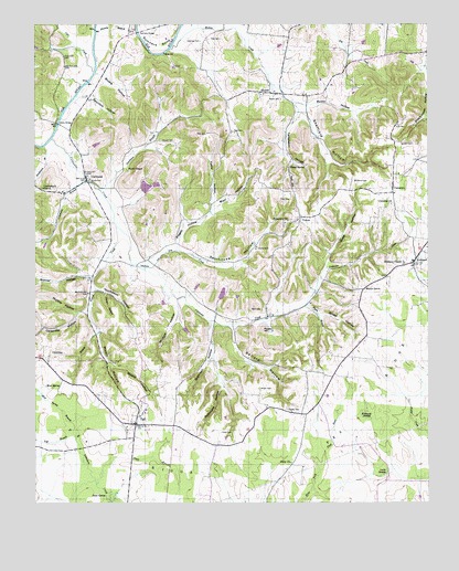
Taft, TN USGS Topographic Map
Click on map above to begin viewing in our Map Viewer.

This topographic map contains these locations and features:
Feature Name Type Latitude Longitude GNIS ID View Map
Abernathy CemeteryCemeteryN35.0384°W86.7469°1645160View Map
Baggerly CemeteryCemeteryN35.0345°W86.7014°1645168View Map
Ballard HollowValleyN35.0462°W86.6868°1276241View Map
Bates CemeteryCemeteryN35.0770°W86.6336°1645169View Map
Bearden CemeteryCemeteryN35.0356°W86.6522°1645172View Map
Birch CreekStreamN35.1179°W86.7075°1312896View Map
Blair CemeteryCemeteryN35.0506°W86.6775°1277637View Map
Blair HollowValleyN35.0778°W86.6913°1277645View Map
Bonner HollowValleyN35.0595°W86.7333°1277955View Map
Boureois FarmLocaleN35.0569°W86.6994°2724550View Map
Bryant CemeteryCemeteryN35.0948°W86.7094°1305483View Map
Bryant HollowValleyN35.0366°W86.7262°1278748View Map
Bryant HollowValleyN35.1120°W86.7280°1278749View Map
Butler CemeteryCemeteryN35.0842°W86.7317°1279172View Map
CamargoPopulated PlaceN35.0823°W86.6358°1279351View Map
Camargo ChurchChurchN35.0781°W86.6367°1279352View Map
Camargo SchoolSchoolN35.0859°W86.6342°1279353View Map
Carpenter BranchStreamN35.0448°W86.7294°1279701View Map
Carpenter CemeteryCemeteryN35.0537°W86.7350°1645189View Map
Carpenter CemeteryCemeteryN35.0334°W86.7358°1645190View Map
Carpenter HollowValleyN35.0495°W86.7363°1279707View Map
Carr CreekStreamN35.1129°W86.7308°1305696View Map
Carter LakeReservoirN35.0547°W86.6904°1301520View Map
Carter Lake DamDamN35.0534°W86.6917°1301521View Map
Cash Point-Blanche Division (historical)CensusN35.0543°W86.7478°1648830View Map
ColdwaterPopulated PlaceN35.0845°W86.7336°1306030View Map
Coldwater CreekStreamN35.0951°W86.7444°1280913View Map
Coldwater FarmsLocaleN35.0786°W86.7172°2724546View Map
Coldwater SchoolSchoolN35.0815°W86.7408°1280914View Map
Cole CemeteryCemeteryN35.0184°W86.6908°1280919View Map
Cole CemeteryCemeteryN35.0562°W86.6255°1645195View Map
Commissioner District 1CivilN35.0512°W86.7201°2464257View Map
Commons BranchStreamN35.0840°W86.7344°1281045View Map
Coneflower FarmLocaleN35.0622°W86.6914°2724545View Map
Cumberland ChurchChurchN35.0823°W86.7472°1281822View Map
Dolan HollowValleyN35.0546°W86.7276°1282618View Map
Double J FarmsLocaleN35.1069°W86.6864°2724554View Map
Dragonfly FarmLocaleN35.0539°W86.7097°2724549View Map
Dry CreekStreamN35.0609°W86.7156°1282901View Map
Dunlap CemeteryCemeteryN35.1054°W86.7442°1645210View Map
Fife CemeteryCemeteryN35.0987°W86.6355°1284249View Map
Flynn BranchStreamN35.0520°W86.6633°1284537View Map
Good HollowValleyN35.0627°W86.6577°1285613View Map
Graham FarmsLocaleN35.0294°W86.6808°2724551View Map
Grider HollowValleyN35.0491°W86.6592°1286258View Map
Hastings CemeteryCemeteryN35.1206°W86.6972°1287096View Map
Henderson BranchStreamN35.0931°W86.7469°1287380View Map
Hobbs BridgeBridgeN35.0990°W86.7422°1287934View Map
Jones BranchStreamN35.0054°W86.7300°1289691View Map
KirklandPopulated PlaceN35.0623°W86.6292°1290298View Map
Kirkland ChapelChurchN35.0626°W86.6325°1290300View Map
Kirkland Chapel CemeteryCemeteryN35.0631°W86.6328°1645258View Map
Laue FarmLocaleN35.0467°W86.6792°2724548View Map
Lincoln County Farm (historical)LocaleN35.0668°W86.6794°1326878View Map
Locke SwampSwampN35.0073°W86.6394°1291768View Map
Louis LakeReservoirN35.0801°W86.7167°1301549View Map
Louis Lake DamDamN35.0801°W86.7167°1301548View Map
Martin HollowValleyN35.0498°W86.7329°1292836View Map
Marys GrovePopulated PlaceN35.0556°W86.6458°1310353View Map
Marys Grove CemeteryCemeteryN35.0551°W86.6411°1645270View Map
Marys Grove SchoolSchoolN35.0559°W86.6450°1292867View Map
McDill HollowValleyN35.1045°W86.6670°1293248View Map
McFerrin CemeteryCemeteryN35.0842°W86.6483°1293292View Map
Milam CemeteryCemeteryN35.0298°W86.6783°1293764View Map
Mineral Springs FarmLocaleN35.0322°W86.7097°2724553View Map
MolinoPopulated PlaceN35.1073°W86.6747°1294151View Map
Molino CreekStreamN35.1184°W86.7067°1294152View Map
Molino School (historical)SchoolN35.1092°W86.6725°1316231View Map
Molino Volunteer Fire RescueBuildingN35.1070°W86.6779°2654203View Map
Motlow FarmsLocaleN35.0969°W86.6858°2724544View Map
Moyers CemeteryCemeteryN35.0590°W86.6380°1645291View Map
Mud SpringSpringN35.0306°W86.7466°1295018View Map
Mud Spring BranchStreamN35.0206°W86.7364°1295019View Map
Mullins HollowValleyN35.0498°W86.7367°1295090View Map
Neeley CemeteryCemeteryN35.0242°W86.6694°1295317View Map
Nickle Creek Sod FarmLocaleN35.0214°W86.6997°2724555View Map
Pinnel CreekStreamN35.0720°W86.7236°1297684View Map
Pisgah HollowValleyN35.0677°W86.7047°1297723View Map
Pitts CemeteryCemeteryN35.0795°W86.6683°1297755View Map
Pitts CemeteryCemeteryN35.0967°W86.6858°1297756View Map
Pitts CemeteryCemeteryN35.0967°W86.6947°1297757View Map
Pitts CemeteryCemeteryN35.1004°W86.6647°1645299View Map
Pitts CemeteryCemeteryN35.1212°W86.6903°1297758View Map
Poorhouse HollowValleyN35.0628°W86.7137°1298155View Map
Potato HillSummitN35.0451°W86.6769°1298328View Map
Prosperity CemeteryCemeteryN35.0729°W86.6703°1645304View Map
Prosperity ChurchChurchN35.0737°W86.6692°1298590View Map
Rawls CemeteryCemeteryN35.1054°W86.6714°1298978View Map
Red HillSummitN35.0854°W86.6689°1299051View Map
Robinson CemeteryCemeteryN35.0365°W86.6930°1645313View Map
Robinson HollowValleyN35.0474°W86.6937°1299708View Map
Sand SpringSpringN35.0021°W86.7274°1300679View Map
Sandlin CemeteryCemeteryN35.0865°W86.6433°1645320View Map
Sandlin CemeteryCemeteryN35.0942°W86.6292°1300722View Map
Sheffield HollowValleyN35.1022°W86.6634°1269978View Map
Shields Gin (historical)LocaleN35.0598°W86.6292°1316246View Map
Smith ChapelChurchN35.0879°W86.7203°1270656View Map
Spout SpringSpringN35.0881°W86.6683°1271026View Map
Spurlock HollowValleyN35.1058°W86.7319°1271174View Map
Stillhouse HollowValleyN35.0301°W86.6903°1271407View Map
Sulser CemeteryCemeteryN35.0306°W86.7219°1645331View Map
Sumners BendBendN35.1237°W86.7103°1271854View Map
Sumners BridgeBridgeN35.1229°W86.7169°1271855View Map
TaftPopulated PlaceN35.0206°W86.7181°1272039View Map
Taft BranchStreamN35.0176°W86.7367°1272040View Map
Taft Post OfficePost OfficeN35.0211°W86.7183°1650347View Map
Taft SchoolSchoolN35.0237°W86.7150°1316247View Map
Templeton HollowValleyN35.1022°W86.6661°1272293View Map
Thompson BranchStreamN35.0501°W86.7325°1312902View Map
Thompson HollowValleyN35.0561°W86.7311°1272545View Map
Tucker Pond (historical)LakeN35.0539°W86.6856°1310366View Map
Twitty HollowValleyN35.0783°W86.6927°1273129View Map
Unity ChurchChurchN35.0106°W86.6686°1273269View Map
Whitaker LakeReservoirN35.0826°W86.7148°1301552View Map
Whitaker Lake DamDamN35.0834°W86.7133°1301553View Map
Whiteoak SwampSwampN35.0232°W86.6446°1274444View Map
Willow Springs FarmLocaleN35.0517°W86.7036°2724552View Map
Winford HollowValleyN35.0519°W86.7044°1274870View Map
YukonPopulated PlaceN35.0748°W86.6658°1314553View Map

Note: Coordinates in the location and feature list above are referenced to NAD83 datum.


Copyright (C) 2008-2024 Ryan Niemi / Sunset Dynamics ... All Rights Reserved