TopoQuest Logo
Do you find TopoQuest useful?
Help keep TopoQuest running and adding new maps/features by donating!
Bitcoin:  19c7KJd3qBynnjoSw5npx9KScwjBe4ifkT
Litecoin:  LXs6TkuXGGXo1vDsWCkWVdjQX94eUKd6ui
Home View Maps Find Maps Find Places Resources & Links


Dunnellon SE, Florida Topographic Map

USGS Map Title: Dunnellon SE, FL
USGS Map MRC: 29082A3
DRG (GeoTIFF) Download: o29082a3.tif


Neighboring USGS Topographic Map Quads:


  Romeo, FL  
29082B4
 

  Cotton Plant, FL  
29082B3
 

  Ocala West, FL  
29082B2
 

  Dunnellon, FL  
29082A4
 

  Dunnellon SE, FL  
29082A3
 

  Shady, FL  
29082A2
 

  Holder, FL  
28082H4
 

  Stokes Ferry, FL  
28082H3
 

  Lake Panasoffkee NW, FL  
28082H2


Map MRC Location:

N30°
W83°
N30°
W82°
H8 H7 H6 H5 H4 H3 H2 H1
G8 G7 G6 G5 G4 G3 G2 G1
F8 F7 F6 F5 F4 F3 F2 F1
E8 E7 E6 E5 E4 E3 E2 E1
D8 D7 D6 D5 D4 D3 D2 D1
C8 C7 C6 C5 C4 C3 C2 C1
B8 B7 B6 B5 B4 B3 B2 B1
A8 A7 A6 A5 A4 A3 A2 A1
N29°
W83°
N29°
W82°

Dunnellon SE, FL USGS 1:24K Topographic Map Preview:
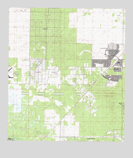
Dunnellon SE, FL USGS Topographic Map
Click on map above to begin viewing in our Map Viewer.

This topographic map contains these locations and features:
Feature Name Type Latitude Longitude GNIS ID View Map
Adams HammockIslandN29.0583°W82.2851°277676View Map
Airport Beacon TowerTowerN29.0633°W82.3690°2053882View Map
Baby Gator Child CareSchoolN29.0580°W82.3351°303304View Map
Cedar Grove ChurchChurchN29.0094°W82.3437°280190View Map
Christian Life Assembly of GodChurchN29.0530°W82.2809°2054483View Map
Circle Square CommonsLocaleN29.1067°W82.2578°2663819View Map
Circle Square RanchLocaleN29.1200°W82.2559°280464View Map
Episcopal Church of the AdventChurchN29.0544°W82.3057°2053880View Map
FAA Radio Control TowerTowerN29.0630°W82.3690°2053883View Map
First Christian ChurchChurchN29.0541°W82.3256°2448782View Map
First Christian Church of DunnellonChurchN29.0544°W82.3254°2053881View Map
Friendship Baptist ChurchChurchN29.0700°W82.2782°2053875View Map
Lake OttingLakeN29.0730°W82.3420°307657View Map
Leroy PondsLakeN29.1195°W82.3317°285467View Map
Living Water Wesleyan ChurchChurchN29.0530°W82.3045°2053879View Map
Marion County AirportAirportN29.0613°W82.3702°309382View Map
Marion County Fire Rescue Station 21 FriendshipBuildingN29.0914°W82.2504°2053831View Map
Marion County Fire Rescue Station 31BuildingN29.0528°W82.3050°2664140View Map
Marion County Sheriff's Office - Southwest DistrictBuildingN29.0668°W82.2692°2333134View Map
Oak Run Water TowerTowerN29.0633°W82.2634°2053872View Map
Oak Run Water Treatment PlantBuildingN29.0566°W82.2665°2053876View Map
Ocala West United Methodist ChurchChurchN29.0697°W82.2743°2053874View Map
Progress Energy Electric SubstationBuildingN29.0533°W82.3065°2053878View Map
Progress Energy Electric Substation-Circle SquareBuildingN29.0789°W82.2554°2053871View Map
Progress Energy Electric Substation-Ross PrairieBuildingN29.0055°W82.2612°2053884View Map
Rolling HillsPopulated PlaceN29.1172°W82.3351°303885View Map
Rolling RanchesPopulated PlaceN29.0661°W82.3440°303884View Map
Ross PondSwampN29.0356°W82.3206°289984View Map
Ross PrairieFlatN29.0378°W82.2859°289985View Map
String of PondsLakeN29.0655°W82.3246°291754View Map
Sumter Electric Cooperative SubstationBuildingN29.0669°W82.2723°2053873View Map
Timber Ridge Community CenterBuildingN29.0616°W82.2948°2053877View Map
Timber Ridge Community ChurchChurchN29.0616°W82.2898°2056142View Map

Note: Coordinates in the location and feature list above are referenced to NAD83 datum.


Copyright (C) 2008-2024 Ryan Niemi / Sunset Dynamics ... All Rights Reserved