TopoQuest Logo
Do you find TopoQuest useful?
Help keep TopoQuest running and adding new maps/features by donating!
Bitcoin:  19c7KJd3qBynnjoSw5npx9KScwjBe4ifkT
Litecoin:  LXs6TkuXGGXo1vDsWCkWVdjQX94eUKd6ui
Home View Maps Find Maps Find Places Resources & Links


Stokes Ferry, Florida Topographic Map

USGS Map Title: Stokes Ferry, FL
USGS Map MRC: 28082H3
DRG (GeoTIFF) Download: o28082h3.tif


Neighboring USGS Topographic Map Quads:


  Dunnellon, FL  
29082A4
 

  Dunnellon SE, FL  
29082A3
 

  Shady, FL  
29082A2
 

  Holder, FL  
28082H4
 

  Stokes Ferry, FL  
28082H3
 

  Lake Panasoffkee NW, FL  
28082H2
 

  Lecanto, FL  
28082G4
 

  Inverness, FL  
28082G3
 

  Rutland, FL  
28082G2


Map MRC Location:

N29°
W83°
N29°
W82°
H8 H7 H6 H5 H4 H3 H2 H1
G8 G7 G6 G5 G4 G3 G2 G1
F8 F7 F6 F5 F4 F3 F2 F1
E8 E7 E6 E5 E4 E3 E2 E1
D8 D7 D6 D5 D4 D3 D2 D1
C8 C7 C6 C5 C4 C3 C2 C1
B8 B7 B6 B5 B4 B3 B2 B1
A8 A7 A6 A5 A4 A3 A2 A1
N28°
W83°
N28°
W82°

Stokes Ferry, FL USGS 1:24K Topographic Map Preview:
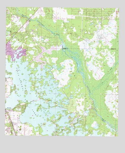
Stokes Ferry, FL USGS Topographic Map
Click on map above to begin viewing in our Map Viewer.

This topographic map contains these locations and features:
Feature Name Type Latitude Longitude GNIS ID View Map
Briggs IslandIslandN28.8864°W82.3312°279392View Map
Christ Way FellowshipChurchN28.8769°W82.3658°2074047View Map
Church Without WallsChurchN28.9206°W82.3700°2374529View Map
Citrus County Fire Rescue Station 15BuildingN28.9652°W82.3740°2644181View Map
Citrus County Fire Rescue Station 5BuildingN28.9007°W82.3734°2053345View Map
Citrus County Sheriffs Office-SubstationBuildingN28.9008°W82.3732°2053346View Map
Citrus Family Worship CenterChurchN28.9003°W82.3740°2053344View Map
Drake Ranch AirportAirportN28.9925°W82.3293°309486View Map
First Baptist ChurchChurchN28.8983°W82.3711°2374530View Map
Gilchrist IslandIslandN28.9030°W82.3376°283073View Map
Gum SloughStreamN28.9164°W82.2818°283551View Map
Gum SwampSwampN28.9337°W82.2611°283557View Map
HernandoPopulated PlaceN28.9000°W82.3745°283922View Map
Hernando Beach and Community ParkBeachN28.9008°W82.3725°2374532View Map
Hernando Church of the NazareneChurchN28.8939°W82.3694°2075065View Map
Hernando Post OfficePost OfficeN28.8991°W82.3713°2374531View Map
Lakeview SchoolSchoolN28.8983°W82.3720°297431View Map
Long ArmCapeN28.9214°W82.2931°285944View Map
Marion County Fire Rescue Station 5 Florida HighlandsBuildingN28.9966°W82.2852°2644015View Map
McDermid DriveAreaN28.9081°W82.3241°286605View Map
Point LonesomeCapeN28.8894°W82.3184°289123View Map
Saint Raphael Orthodox ChurchChurchN28.8811°W82.3653°2075064View Map
Spooner IslandIslandN28.9431°W82.3688°2741506View Map
Spooner IslandIslandN28.8942°W82.3393°2742237View Map
Stokes FerryLocaleN28.9878°W82.3501°291716View Map
The PocketIslandN28.9575°W82.3540°292178View Map
Tsala Apopka LakeLakeN28.8753°W82.3026°294179View Map
Twelve Oaks AirportAirportN28.9792°W82.3635°309485View Map
WRZN-AM (Hernando)TowerN28.9228°W82.3723°310070View Map

Note: Coordinates in the location and feature list above are referenced to NAD83 datum.


Copyright (C) 2008-2024 Ryan Niemi / Sunset Dynamics ... All Rights Reserved