TopoQuest Logo
Do you find TopoQuest useful?
Help keep TopoQuest running and adding new maps/features by donating!
Bitcoin:  19c7KJd3qBynnjoSw5npx9KScwjBe4ifkT
Litecoin:  LXs6TkuXGGXo1vDsWCkWVdjQX94eUKd6ui
Home View Maps Find Maps Find Places Resources & Links


Fairmont, Nebraska Topographic Map

USGS Map Title: Fairmont, NE
USGS Map MRC: 40097F5
DRG (GeoTIFF) Download: o40097f5.tif


Neighboring USGS Topographic Map Quads:


  York SW, NE  
40097G6
 

  York South, NE  
40097G5
 

  Utica SW, NE  
40097G4
 

  Grafton, NE  
40097F6
 

  Fairmont, NE  
40097F5
 

  Exeter, NE  
40097F4
 

  Geneva SW, NE  
40097E6
 

  Geneva, NE  
40097E5
 

  Friend SW, NE  
40097E4


Map MRC Location:

N41°
W98°
N41°
W97°
H8 H7 H6 H5 H4 H3 H2 H1
G8 G7 G6 G5 G4 G3 G2 G1
F8 F7 F6 F5 F4 F3 F2 F1
E8 E7 E6 E5 E4 E3 E2 E1
D8 D7 D6 D5 D4 D3 D2 D1
C8 C7 C6 C5 C4 C3 C2 C1
B8 B7 B6 B5 B4 B3 B2 B1
A8 A7 A6 A5 A4 A3 A2 A1
N40°
W98°
N40°
W97°

Fairmont, NE USGS 1:24K Topographic Map Preview:
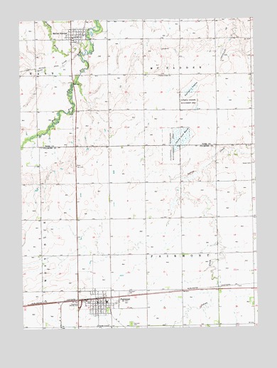
Fairmont, NE USGS Topographic Map
Click on map above to begin viewing in our Map Viewer.

This topographic map contains these locations and features:
Feature Name Type Latitude Longitude GNIS ID View Map
County Line Federal Waterfowl Production AreaParkN40.7028°W97.5420°1882001View Map
County Line MarshSwampN40.7017°W97.5400°828409View Map
Crosstrails Wayside ParkParkN40.6353°W97.5948°828485View Map
Dorchester Farmers Co-op Association ElevatorLocaleN40.6370°W97.5853°1882259View Map
FairmontPopulated PlaceN40.6370°W97.5853°829215View Map
FairmontLocaleN40.6372°W97.5864°1882299View Map
Fairmont Army Air Field Historical MarkerParkN40.6361°W97.5956°1882305View Map
Fairmont CemeteryCemeteryN40.6267°W97.5678°829216View Map
Fairmont CemeteryCemeteryN40.6394°W97.5692°829217View Map
Fairmont Creamery Company Historical MarkerParkN40.6361°W97.5850°1882306View Map
Fairmont Post OfficePost OfficeN40.6363°W97.5855°1882263View Map
Fairmont Public LibraryBuildingN40.6370°W97.5853°1882265View Map
Fairmont Public SchoolsSchoolN40.6358°W97.5806°1882300View Map
Fairmont Volunteer Fire DepartmentBuildingN40.6354°W97.5849°2553286View Map
Fairview ManorHospitalN40.6370°W97.5853°1882264View Map
Farmers Co-op ElevatorLocaleN40.7445°W97.5909°1882103View Map
Fillmore County MuseumBuildingN40.6370°W97.5853°1882261View Map
First Evangelical Lutheran ChurchChurchN40.7439°W97.5950°1882104View Map
Galaway CreekStreamN40.7417°W97.5875°829439View Map
H and D CampgroundLocaleN40.7442°W97.5975°1882100View Map
Horton CemeteryCemeteryN40.6911°W97.5028°830160View Map
Manning Grain Company ElevatorLocaleN40.6370°W97.5853°1882260View Map
McCool JunctionPopulated PlaceN40.7442°W97.5975°831119View Map
McCool Junction (historical)LocaleN40.7450°W97.5912°1882101View Map
McCool Junction Post OfficePost OfficeN40.7439°W97.5934°1882102View Map
McCool Junction Public SchoolsSchoolN40.7428°W97.5939°1882107View Map
McCool Junction Rural Fire DistrictBuildingN40.7427°W97.5997°2553404View Map
McFadden Election PrecinctCivilN40.7420°W97.5402°1929057View Map
Pleasant Ridge CemeteryCemeteryN40.7272°W97.5514°832212View Map
Real Federal Waterfowl Production AreaParkN40.6700°W97.5767°1882221View Map
Saint Patrick Catholic ChurchChurchN40.7442°W97.5975°1882106View Map
Sininger LagoonSwampN40.7213°W97.5345°833462View Map
Sinninger Federal Waterfowl Production AreaParkN40.7161°W97.5351°1882002View Map
Stone CreekStreamN40.7364°W97.5925°833841View Map
Township of Fairmont (historical)CivilN40.6620°W97.5450°838001View Map
Township of McFaddenCivilN40.7417°W97.5392°1881991View Map
United Methodist ChurchChurchN40.6370°W97.5853°1882262View Map
United Methodist ChurchChurchN40.7433°W97.5950°1882105View Map
Village of FairmontCivilN40.6331°W97.5879°2398854View Map
Village of McCool JunctionCivilN40.7439°W97.6005°2399290View Map
Weiss ReservoirLakeN40.7211°W97.6179°1770127View Map
Weiss Road DamDamN40.7227°W97.6166°1770126View Map

Note: Coordinates in the location and feature list above are referenced to NAD83 datum.


Copyright (C) 2008-2024 Ryan Niemi / Sunset Dynamics ... All Rights Reserved