TopoQuest Logo
Do you find TopoQuest useful?
Help keep TopoQuest running and adding new maps/features by donating!
Bitcoin:  19c7KJd3qBynnjoSw5npx9KScwjBe4ifkT
Litecoin:  LXs6TkuXGGXo1vDsWCkWVdjQX94eUKd6ui
Home View Maps Find Maps Find Places Resources & Links


Fidelity, Missouri Topographic Map

USGS Map Title: Fidelity, MO
USGS Map MRC: 37094A3
DRG (GeoTIFF) Download: o37094a3.tif


Neighboring USGS Topographic Map Quads:


  Webb City, MO  
37094B4
 

  Carthage, MO  
37094B3
 

  Avilla, MO  
37094B2
 

  Joplin East, MO  
37094A4
 

  Fidelity, MO  
37094A3
 

  Reeds, MO  
37094A2
 

  Tipton Ford, MO  
36094H4
 

  Granby, MO  
36094H3
 

  Newtonia, MO  
36094H2


Map MRC Location:

N38°
W95°
N38°
W94°
H8 H7 H6 H5 H4 H3 H2 H1
G8 G7 G6 G5 G4 G3 G2 G1
F8 F7 F6 F5 F4 F3 F2 F1
E8 E7 E6 E5 E4 E3 E2 E1
D8 D7 D6 D5 D4 D3 D2 D1
C8 C7 C6 C5 C4 C3 C2 C1
B8 B7 B6 B5 B4 B3 B2 B1
A8 A7 A6 A5 A4 A3 A2 A1
N37°
W95°
N37°
W94°

Fidelity, MO USGS 1:24K Topographic Map Preview:
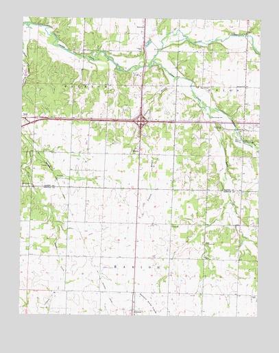
Fidelity, MO USGS Topographic Map
Click on map above to begin viewing in our Map Viewer.

This topographic map contains these locations and features:
Feature Name Type Latitude Longitude GNIS ID View Map
Berean School (historical)SchoolN37.1214°W94.3119°713983View Map
Brown School (historical)SchoolN37.0290°W94.3594°746319View Map
BrownsLocaleN37.0465°W94.3519°740371View Map
Center ChurchChurchN37.0781°W94.2588°715634View Map
Church of GodChurchN37.0834°W94.3724°715839View Map
Diamond Grove ChurchChurchN37.0540°W94.3741°716876View Map
Emanuel ChurchChurchN37.0970°W94.2583°717566View Map
Excelsior School (historical)SchoolN37.0667°W94.2761°746124View Map
Farney CemeteryCemeteryN37.0087°W94.2535°717855View Map
FidelityPopulated PlaceN37.0681°W94.3133°729887View Map
Fidelity BranchStreamN37.1003°W94.2949°717897View Map
Fidelity CemeteryCemeteryN37.0762°W94.3122°717898View Map
Fidelity School (historical)SchoolN37.0678°W94.3136°746122View Map
Fullerton CemeteryCemeteryN37.1120°W94.3122°718290View Map
Jenkins CreekStreamN37.0881°W94.2805°720294View Map
Jones CreekStreamN37.1053°W94.3091°720415View Map
KKLL-AM (Webb City)TowerN37.1064°W94.2808°754272View Map
Liberty ChurchChurchN37.0378°W94.2958°720970View Map
Liberty Community HallLocaleN37.0309°W94.2780°729918View Map
Modern School (historical)SchoolN37.0385°W94.3145°2709596View Map
Moss Springs CemeteryCemeteryN37.0839°W94.2758°722679View Map
Moss Springs Picnic AreaLocaleN37.0789°W94.2711°722680View Map
Pearl Hill School (historical)SchoolN37.0964°W94.2772°729943View Map
Stone CemeteryCemeteryN37.0578°W94.3549°727127View Map
Stony Point School (historical)SchoolN37.0712°W94.3499°746121View Map
Town of FidelityCivilN37.0817°W94.3096°2396937View Map
Township of JacksonCivilN37.1043°W94.3486°766809View Map
Township of MarionCivilN37.0097°W94.3154°767077View Map
Victory School (historical)SchoolN37.0948°W94.3133°746120View Map

Note: Coordinates in the location and feature list above are referenced to NAD83 datum.


Copyright (C) 2008-2024 Ryan Niemi / Sunset Dynamics ... All Rights Reserved