TopoQuest Logo
Do you find TopoQuest useful?
Help keep TopoQuest running and adding new maps/features by donating!
Bitcoin:  19c7KJd3qBynnjoSw5npx9KScwjBe4ifkT
Litecoin:  LXs6TkuXGGXo1vDsWCkWVdjQX94eUKd6ui
Home View Maps Find Maps Find Places Resources & Links


Gilt Edge, Tennessee Topographic Map

USGS Map Title: Gilt Edge, TN
USGS Map MRC: 35089E7
DRG (GeoTIFF) Download: o35089e7.tif


Neighboring USGS Topographic Map Quads:


  Osceola, AR  
35089F8
 

  Golddust, TN  
35089F7
 

  Fort Pillow, TN  
35089F6
 

  Nodena, AR  
35089E8
 

  Gilt Edge, TN  
35089E7
 

  Covington, TN  
35089E6
 

  Drummonds, TN  
35089D8
 

  Munford, TN  
35089D7
 

  Brighton, TN  
35089D6


Map MRC Location:

N36°
W90°
N36°
W89°
H8 H7 H6 H5 H4 H3 H2 H1
G8 G7 G6 G5 G4 G3 G2 G1
F8 F7 F6 F5 F4 F3 F2 F1
E8 E7 E6 E5 E4 E3 E2 E1
D8 D7 D6 D5 D4 D3 D2 D1
C8 C7 C6 C5 C4 C3 C2 C1
B8 B7 B6 B5 B4 B3 B2 B1
A8 A7 A6 A5 A4 A3 A2 A1
N35°
W90°
N35°
W89°

Gilt Edge, TN USGS 1:24K Topographic Map Preview:
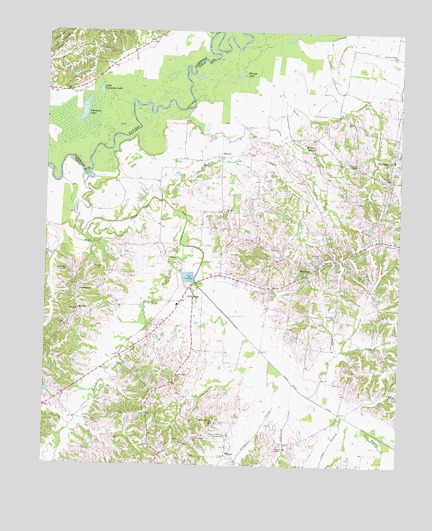
Gilt Edge, TN USGS Topographic Map
Click on map above to begin viewing in our Map Viewer.

This topographic map contains these locations and features:
Feature Name Type Latitude Longitude GNIS ID View Map
Adkinson CreekStreamN35.5240°W89.7873°1275491View Map
Alston School (historical)SchoolN35.5076°W89.8251°1317100View Map
BeaverPopulated PlaceN35.5026°W89.8109°1276706View Map
Beaver Baptist ChurchChurchN35.5031°W89.8106°1644834View Map
Bright Hill ChurchChurchN35.5556°W89.8673°1305419View Map
BurlisonPopulated PlaceN35.5570°W89.7790°1279062View Map
Burlison City HallBuildingN35.5573°W89.7781°1317113View Map
Burlison Post OfficePost OfficeN35.5649°W89.7576°1650728View Map
Burlison School (historical)SchoolN35.5573°W89.7781°1317114View Map
Cane BranchStreamN35.5148°W89.7698°1279498View Map
Carey Chapel (historical)ChurchN35.5545°W89.8651°1317118View Map
Champion LakeLakeN35.6020°W89.8618°1280226View Map
City of Gilt EdgeCivilN35.5336°W89.8303°2403699View Map
Commissioner District 3CivilN35.5660°W89.7698°2464201View Map
DetroitPopulated PlaceN35.5890°W89.8137°1314945View Map
Detroit School (historical)SchoolN35.5892°W89.8112°1317132View Map
Dickens CemeteryCemeteryN35.5565°W89.8542°1282429View Map
Elm GrovePopulated PlaceN35.5729°W89.8126°1647400View Map
Elm Grove ChurchChurchN35.5642°W89.8020°1283708View Map
Elm Grove ChurchChurchN35.5734°W89.8120°1283709View Map
FlatwoodPopulated PlaceN35.5234°W89.8287°1310746View Map
GarlandPopulated PlaceN35.5884°W89.7526°1285165View Map
Garland Baptist ChurchChurchN35.5906°W89.7517°1317143View Map
Garland Community CenterBuildingN35.5881°W89.7523°1317144View Map
Garland Division (historical)CensusN35.5737°W89.7615°1648981View Map
Garland School (historical)SchoolN35.5881°W89.7523°1317146View Map
Garland United Methodist ChurchChurchN35.5884°W89.7531°1317147View Map
Garland Volunteer Fire DepartmentBuildingN35.5825°W89.7543°2653897View Map
Gilt EdgePopulated PlaceN35.5512°W89.8245°1285436View Map
Gilt Edge Church of ChristChurchN35.5470°W89.8276°1317149View Map
Gilt Edge SchoolSchoolN35.5462°W89.8287°1317150View Map
Gilt Edge Volunteer Fire DepartmentBuildingN35.5509°W89.8239°2653896View Map
Groggins CreekStreamN35.5304°W89.7954°1286335View Map
Healing Mission ChurchChurchN35.5129°W89.8151°1287284View Map
Hodges CreekStreamN35.5765°W89.8340°1287967View Map
Hurricane CreekStreamN35.5637°W89.8276°1288807View Map
Indian CreekStreamN35.5848°W89.8620°1288943View Map
Indian Creek CanalCanalN35.5195°W89.7801°1288968View Map
JamestownPopulated PlaceN35.5512°W89.8623°1289286View Map
Jamestown School (historical)SchoolN35.5473°W89.8645°1317155View Map
Kays ChapelChurchN35.5520°W89.8631°1317156View Map
Kelleys ChapelChurchN35.5870°W89.7654°1290012View Map
Little Champion LakeLakeN35.6081°W89.8561°1291423View Map
Mount Pisgah ChurchChurchN35.5448°W89.8631°1294739View Map
Mrs Ardell Blankenship DamDamN35.5684°W89.7634°1301927View Map
Mrs Ardell Blankenship LakeReservoirN35.5686°W89.7623°1301928View Map
Myron CreekStreamN35.5104°W89.7598°1295197View Map
New Hope ChurchChurchN35.5429°W89.7729°1295529View Map
New Salem ChurchChurchN35.5256°W89.8279°1295635View Map
Pentecost ChurchChurchN35.5892°W89.8131°1317178View Map
Ravenscroft CemeteryCemeteryN35.5079°W89.8223°1298976View Map
Ravenscroft ChapelChurchN35.5048°W89.7926°1317187View Map
Rose of Sharon CampgroundLocaleN35.5087°W89.8104°1300058View Map
Rose of Sharon Campground ChurchChurchN35.5084°W89.8106°1317193View Map
Shingle LakeLakeN35.6129°W89.8069°1270104View Map
Smyrna CemeteryCemeteryN35.5609°W89.7779°1270738View Map
Smyrna ChurchChurchN35.5592°W89.7767°1317207View Map
Town of BurlisonCivilN35.5570°W89.7846°2405346View Map
Union Grove CemeteryCemeteryN35.5070°W89.8254°1273218View Map
Union Grove ChurchChurchN35.5070°W89.8254°1317213View Map
Walnut GrovePopulated PlaceN35.5920°W89.7806°1273713View Map
Walnut Grove Cumberland Presbyterian ChurchChurchN35.5895°W89.7812°1317217View Map
Western Valley ChurchChurchN35.6184°W89.7523°1304490View Map
Witherington DamDamN35.5217°W89.8734°1301897View Map
Witherington LakeReservoirN35.5216°W89.8741°1301896View Map

Note: Coordinates in the location and feature list above are referenced to NAD83 datum.


Copyright (C) 2008-2024 Ryan Niemi / Sunset Dynamics ... All Rights Reserved