TopoQuest Logo
Do you find TopoQuest useful?
Help keep TopoQuest running and adding new maps/features by donating!
Bitcoin:  19c7KJd3qBynnjoSw5npx9KScwjBe4ifkT
Litecoin:  LXs6TkuXGGXo1vDsWCkWVdjQX94eUKd6ui
Home View Maps Find Maps Find Places Resources & Links


Drummonds, Tennessee Topographic Map

USGS Map Title: Drummonds, TN
USGS Map MRC: 35089D8
DRG (GeoTIFF) Download: o35089d8.tif


Neighboring USGS Topographic Map Quads:


  Wilson, AR  
35090E1
 

  Nodena, AR  
35089E8
 

  Gilt Edge, TN  
35089E7
 

  Pecan Point, AR  
35090D1
 

  Drummonds, TN  
35089D8
 

  Munford, TN  
35089D7
 

  Locke, TN  
35090C1
 

  Millington, TN  
35089C8
 

  Brunswick, TN  
35089C7


Map MRC Location:

N36°
W90°
N36°
W89°
H8 H7 H6 H5 H4 H3 H2 H1
G8 G7 G6 G5 G4 G3 G2 G1
F8 F7 F6 F5 F4 F3 F2 F1
E8 E7 E6 E5 E4 E3 E2 E1
D8 D7 D6 D5 D4 D3 D2 D1
C8 C7 C6 C5 C4 C3 C2 C1
B8 B7 B6 B5 B4 B3 B2 B1
A8 A7 A6 A5 A4 A3 A2 A1
N35°
W90°
N35°
W89°

Drummonds, TN USGS 1:24K Topographic Map Preview:
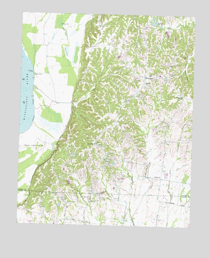
Drummonds, TN USGS Topographic Map
Click on map above to begin viewing in our Map Viewer.

This topographic map contains these locations and features:
Feature Name Type Latitude Longitude GNIS ID View Map
Bear CreekStreamN35.4570°W89.9906°1276576View Map
Bridge SloughGutN35.4895°W89.9687°1278351View Map
Campground Spring CreekStreamN35.4123°W89.8879°1279483View Map
Cedar PointCapeN35.4637°W89.9904°1280087View Map
Cedar Point DikesLeveeN35.4334°W89.9918°1310741View Map
Cedar Point LandingLocaleN35.4654°W89.9906°1314810View Map
Cole CreekStreamN35.3798°W89.9170°1280929View Map
Commissioner District 6CivilN35.4703°W89.9796°2464577View Map
Cooper School (historical)SchoolN35.4204°W89.8948°1317122View Map
Densford RevetmentLeveeN35.4423°W89.9898°1306329View Map
DixonvillePopulated PlaceN35.4231°W89.9459°1282527View Map
Dixonville School (historical)SchoolN35.4231°W89.9456°1317135View Map
DrummondsPopulated PlaceN35.4634°W89.9101°1282816View Map
Drummonds Division (historical)CensusN35.4529°W89.9345°1648980View Map
Drummonds Elementary SchoolSchoolN35.4642°W89.9065°1648301View Map
Drummonds Post OfficePost OfficeN35.4634°W89.9110°1650727View Map
Dry BranchStreamN35.4051°W89.8901°1282878View Map
Fellowship Baptist ChurchChurchN35.4118°W89.9348°1644839View Map
Forest Strip Airport (historical)AirportN35.3751°W89.9918°1301332View Map
Gideon Church (historical)ChurchN35.4459°W89.9606°1317148View Map
Hickory HollowValleyN35.4646°W89.8839°1647402View Map
Holiness Church (historical)ChurchN35.4690°W89.9209°1317152View Map
Jerusalem ChurchChurchN35.4226°W89.9445°1289411View Map
Leaf LakeReservoirN35.4959°W89.9043°1290871View Map
Leaf Lake DamDamN35.4942°W89.9026°1307122View Map
Mount Harmon ChurchChurchN35.4234°W89.9451°1294618View Map
Neal LandingLocaleN35.4873°W89.9959°1317176View Map
New Bethel ChurchChurchN35.3909°W89.9684°1295425View Map
Peckerwood PointPopulated PlaceN35.4517°W89.8820°1315689View Map
Poplar Grove CemeteryCemeteryN35.4615°W89.9120°1298190View Map
Poplar Grove ChurchChurchN35.4595°W89.9095°1298194View Map
Poplar Grove ChurchChurchN35.4704°W89.8926°1298195View Map
QuitoPopulated PlaceN35.4131°W89.9345°1298768View Map
Quito Community CenterBuildingN35.4120°W89.9348°1317185View Map
Quito Memorial CemeteryCemeteryN35.4017°W89.9270°1284191View Map
Quito Methodist ChurchChurchN35.4126°W89.9343°1317260View Map
Quito School (historical)SchoolN35.4120°W89.9348°1317186View Map
Quito Volunteer Fire Department Station 1BuildingN35.4139°W89.9333°2654168View Map
Quito Volunteer Fire Department Station 2BuildingN35.4647°W89.8975°2654167View Map
Rays LakeReservoirN35.4162°W89.9597°1301819View Map
Rays Lake DamDamN35.4151°W89.9601°1301820View Map
Round PondSwampN35.4780°W89.9675°1300177View Map
Saint Marks CemeteryCemeteryN35.4126°W89.9092°1300471View Map
Saint Marks ChurchChurchN35.4073°W89.8951°1300472View Map
Saint PaulPopulated PlaceN35.4931°W89.9440°1647404View Map
Saint Paul School (historical)SchoolN35.4934°W89.9443°1317199View Map
Saint Pauls ChurchChurchN35.4931°W89.9440°1300507View Map
Saluted CemeteryCemeteryN35.3792°W89.8981°1300615View Map
Sigler Island Number Thirty-sixFlatN35.4168°W89.9948°1314088View Map
Sneed FarmLocaleN35.3994°W89.9000°2678207View Map
Sullivan LakeLakeN35.4937°W89.9724°1271761View Map
Towering HeightsPopulated PlaceN35.4829°W89.9448°1647405View Map
WilkinsvillePopulated PlaceN35.4031°W89.8968°1274604View Map

Note: Coordinates in the location and feature list above are referenced to NAD83 datum.


Copyright (C) 2008-2024 Ryan Niemi / Sunset Dynamics ... All Rights Reserved