TopoQuest Logo
Do you find TopoQuest useful?
Help keep TopoQuest running and adding new maps/features by donating!
Bitcoin:  19c7KJd3qBynnjoSw5npx9KScwjBe4ifkT
Litecoin:  LXs6TkuXGGXo1vDsWCkWVdjQX94eUKd6ui
Home View Maps Find Maps Find Places Resources & Links


Granger, Texas Topographic Map

USGS Map Title: Granger, TX
USGS Map MRC: 30097F4
DRG (GeoTIFF) Download: o30097f4.tif


Neighboring USGS Topographic Map Quads:


  Jarrell, TX  
30097G5
 

  Bartlett, TX  
30097G4
 

  Davilla, TX  
30097G3
 

  Weir, TX  
30097F5
 

  Granger, TX  
30097F4
 

  Granger Lake, TX  
30097F3
 

  Hutto, TX  
30097E5
 

  Taylor, TX  
30097E4
 

  Thrall, TX  
30097E3


Map MRC Location:

N31°
W98°
N31°
W97°
H8 H7 H6 H5 H4 H3 H2 H1
G8 G7 G6 G5 G4 G3 G2 G1
F8 F7 F6 F5 F4 F3 F2 F1
E8 E7 E6 E5 E4 E3 E2 E1
D8 D7 D6 D5 D4 D3 D2 D1
C8 C7 C6 C5 C4 C3 C2 C1
B8 B7 B6 B5 B4 B3 B2 B1
A8 A7 A6 A5 A4 A3 A2 A1
N30°
W98°
N30°
W97°

Granger, TX USGS 1:24K Topographic Map Preview:
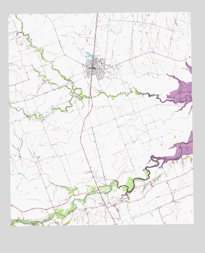
Granger, TX USGS Topographic Map
Click on map above to begin viewing in our Map Viewer.

This topographic map contains these locations and features:
Feature Name Type Latitude Longitude GNIS ID View Map
Calvary CemeteryCemeteryN30.7113°W97.4731°1353570View Map
CirclevillePopulated PlaceN30.6374°W97.4356°1379550View Map
City of GrangerCivilN30.7180°W97.4411°2410639View Map
Comanche BluffCliffN30.6521°W97.4128°1354822View Map
Crispus Attucks SchoolSchoolN30.7252°W97.4414°1355362View Map
Gardner CemeteryCemeteryN30.6355°W97.4453°1357885View Map
GrangerPopulated PlaceN30.7177°W97.4428°1358264View Map
Granger CemeteryCemeteryN30.7180°W97.4269°1358265View Map
Granger City HallBuildingN30.7173°W97.4408°2753533View Map
Granger DivisionCivilN30.7249°W97.4331°1938803View Map
Granger Police DepartmentBuildingN30.7167°W97.4416°2739172View Map
Granger Post OfficePost OfficeN30.7176°W97.4447°2731821View Map
Granger Volunteer Fire DepartmentBuildingN30.7168°W97.4417°2552380View Map
Holy Cross CemeteryCemeteryN30.7188°W97.4256°1359470View Map
Hoxie BridgeBridgeN30.6735°W97.3772°1359749View Map
Macedonia CemeteryCemeteryN30.6919°W97.4839°1362020View Map
Machu CemeteryCemeteryN30.6894°W97.3869°1362036View Map
McFadin CemeteryCemeteryN30.6441°W97.4175°1362448View Map
McFadin HouseBuildingN30.6385°W97.4261°2030733View Map
Opossum CreekStreamN30.7010°W97.4497°1364570View Map
Pecan BranchStreamN30.6488°W97.4322°1364956View Map
Railroad ReservoirReservoirN30.7250°W97.4434°1856888View Map
Railroad Reservoir DamDamN30.7235°W97.4419°1856887View Map
San Gabriel Wildlife AreaParkN30.6796°W97.3881°2029382View Map
Sloan- Easley CemeteryCemeteryN30.6255°W97.4836°1368434View Map
Vitek Field Airport (historical)AirportN30.7294°W97.4253°1386761View Map
WaterlooPopulated PlaceN30.6388°W97.3883°1380746View Map
Willis Creek ParkParkN30.6919°W97.3942°2029974View Map
Willis Creek Wildlife AreaParkN30.7069°W97.4006°2029975View Map
Yankee BranchStreamN30.7016°W97.4525°1372007View Map

Note: Coordinates in the location and feature list above are referenced to NAD83 datum.


Copyright (C) 2008-2024 Ryan Niemi / Sunset Dynamics ... All Rights Reserved