TopoQuest Logo
Do you find TopoQuest useful?
Help keep TopoQuest running and adding new maps/features by donating!
Bitcoin:  19c7KJd3qBynnjoSw5npx9KScwjBe4ifkT
Litecoin:  LXs6TkuXGGXo1vDsWCkWVdjQX94eUKd6ui
Home View Maps Find Maps Find Places Resources & Links


Davilla, Texas Topographic Map

USGS Map Title: Davilla, TX
USGS Map MRC: 30097G3
DRG (GeoTIFF) Download: o30097g3.tif


Neighboring USGS Topographic Map Quads:


  Holland, TX  
30097H4
 

  Little River, TX  
30097H3
 

  Rogers, TX  
30097H2
 

  Bartlett, TX  
30097G4
 

  Davilla, TX  
30097G3
 

  Sharp, TX  
30097G2
 

  Granger, TX  
30097F4
 

  Granger Lake, TX  
30097F3
 

  San Gabriel, TX  
30097F2


Map MRC Location:

N31°
W98°
N31°
W97°
H8 H7 H6 H5 H4 H3 H2 H1
G8 G7 G6 G5 G4 G3 G2 G1
F8 F7 F6 F5 F4 F3 F2 F1
E8 E7 E6 E5 E4 E3 E2 E1
D8 D7 D6 D5 D4 D3 D2 D1
C8 C7 C6 C5 C4 C3 C2 C1
B8 B7 B6 B5 B4 B3 B2 B1
A8 A7 A6 A5 A4 A3 A2 A1
N30°
W98°
N30°
W97°

Davilla, TX USGS 1:24K Topographic Map Preview:
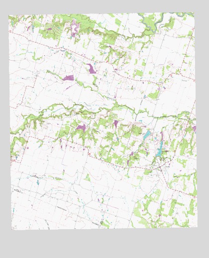
Davilla, TX USGS Topographic Map
Click on map above to begin viewing in our Map Viewer.

This topographic map contains these locations and features:
Feature Name Type Latitude Longitude GNIS ID View Map
Allison CemeteryCemeteryN30.7607°W97.2694°2041464View Map
Darrs CreekStreamN30.8655°W97.2803°1355658View Map
DavillaPopulated PlaceN30.7857°W97.2750°1355683View Map
Davilla CemeteryCemeteryN30.7863°W97.2842°1355684View Map
Davilla Post OfficePost OfficeN30.7845°W97.2748°2731884View Map
DonahoePopulated PlaceN30.8160°W97.3331°1379673View Map
Dripping SpringsSpringN30.7899°W97.2719°1356259View Map
Flag BranchStreamN30.8230°W97.3039°1357398View Map
Hennington CemeteryCemeteryN30.8310°W97.2936°1359038View Map
Indian CreekStreamN30.8071°W97.3708°1359933View Map
Isbell Ranch AirportAirportN30.8085°W97.2739°1386508View Map
Jackson CemeteryCemeteryN30.8113°W97.3500°1360100View Map
Mill BranchStreamN30.8121°W97.2533°1362846View Map
Mumford CemeteryCemeteryN30.8119°W97.2572°2041462View Map
Neusch Lake Number 1ReservoirN30.7969°W97.2752°1858951View Map
Neusch Lake Number 1 DamDamN30.7969°W97.2753°1858950View Map
Pennington BranchStreamN30.8302°W97.3161°1365042View Map
Pruett Family CemeteryCemeteryN30.8102°W97.2528°2041463View Map
Science Hill CemeteryCemeteryN30.8185°W97.3328°1367868View Map
Server BranchStreamN30.8141°W97.2758°1367960View Map
Server CemeteryCemeteryN30.7882°W97.2983°1367961View Map
Simmons CemeteryCemeteryN30.8313°W97.2939°1368291View Map
Soil Conservation Service Site 5 DamDamN30.8358°W97.3362°1863194View Map
Soil Conservation Service Site 5 ReservoirReservoirN30.8381°W97.3350°1863195View Map
Soil Conservation Service Site 6 DamDamN30.8404°W97.3206°1863196View Map
Soil Conservation Service Site 6 ReservoirReservoirN30.8429°W97.3198°1863197View Map
Soil Conservation Service Site 7 DamDamN30.8102°W97.3236°1858884View Map
Soil Conservation Service Site 7 ReservoirReservoirN30.8092°W97.3271°1858885View Map
Soil Conservation Service Site 8 DamDamN30.8135°W97.3019°1858886View Map
Soil Conservation Service Site 8 ReservoirReservoirN30.8135°W97.3019°1858887View Map
Soil Conservation Service Site 9 DamDamN30.8102°W97.2519°1858954View Map
Soil Conservation Service Site 9 ReservoirReservoirN30.8078°W97.2515°1858955View Map
Stigall Lake Number 2 DamDamN30.8069°W97.2819°1858952View Map
Stigall Lake Number OneReservoirN30.7938°W97.2752°1369197View Map
Stigall Lake Number TwoReservoirN30.8049°W97.2828°1858953View Map
Val Verde CemeteryCemeteryN30.8353°W97.2727°2041461View Map
Val Verde ChurchChurchN30.8352°W97.2725°1370545View Map
VilasPopulated PlaceN30.8410°W97.3036°1380724View Map

Note: Coordinates in the location and feature list above are referenced to NAD83 datum.


Copyright (C) 2008-2024 Ryan Niemi / Sunset Dynamics ... All Rights Reserved