TopoQuest Logo
Do you find TopoQuest useful?
Help keep TopoQuest running and adding new maps/features by donating!
Bitcoin:  19c7KJd3qBynnjoSw5npx9KScwjBe4ifkT
Litecoin:  LXs6TkuXGGXo1vDsWCkWVdjQX94eUKd6ui
Home View Maps Find Maps Find Places Resources & Links


Green Lake, Wisconsin Topographic Map

USGS Map Title: Green Lake, WI
USGS Map MRC: 43088G8
DRG (GeoTIFF) Download: o43088g8.tif


Neighboring USGS Topographic Map Quads:


  Fairburn, WI  
43089H1
 

  Berlin, WI  
43088H8
 

  Rush Lake, WI  
43088H7
 

  Princeton East, WI  
43089G1
 

  Green Lake, WI  
43088G8
 

  Ripon, WI  
43088G7
 

  Manchester, WI  
43089F1
 

  Markesan, WI  
43088F8
 

  Brandon, WI  
43088F7


Map MRC Location:

N44°
W89°
N44°
W88°
H8 H7 H6 H5 H4 H3 H2 H1
G8 G7 G6 G5 G4 G3 G2 G1
F8 F7 F6 F5 F4 F3 F2 F1
E8 E7 E6 E5 E4 E3 E2 E1
D8 D7 D6 D5 D4 D3 D2 D1
C8 C7 C6 C5 C4 C3 C2 C1
B8 B7 B6 B5 B4 B3 B2 B1
A8 A7 A6 A5 A4 A3 A2 A1
N43°
W89°
N43°
W88°

Green Lake, WI USGS 1:24K Topographic Map Preview:
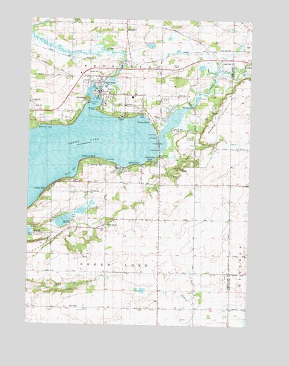
Green Lake, WI USGS Topographic Map
Click on map above to begin viewing in our Map Viewer.

This topographic map contains these locations and features:
Feature Name Type Latitude Longitude GNIS ID View Map
Apple Grove School (historical)SchoolN43.7933°W88.8859°1560907View Map
Big Twin LakeLakeN43.7922°W88.9803°2786113View Map
Bluffton CemeteryCemeteryN43.8739°W88.9765°1843720View Map
Bluffton School (historical)SchoolN43.8747°W88.9871°1561984View Map
Center HousePopulated PlaceN43.7905°W88.9557°1562885View Map
City of Green LakeCivilN43.8435°W88.9572°1583318View Map
Dakin CreekStreamN43.8211°W88.9243°1563666View Map
Dakin School (historical)SchoolN43.8144°W88.9001°1563667View Map
Dartford BayBayN43.8386°W88.9640°1563720View Map
Dartford CemeteryCemeteryN43.8522°W88.9654°1843723View Map
Dartford Mill PondReservoirN43.8425°W88.9640°1843724View Map
Federated Church of Green LakeChurchN43.8494°W88.9607°1843732View Map
Forest Glen BeachPopulated PlaceN43.8169°W88.9323°1565115View Map
Forest Ridge School (historical)SchoolN43.8508°W88.9257°1565139View Map
Green LakePopulated PlaceN43.8441°W88.9601°1565822View Map
Green Lake - Brooklyn Fire DepartmentBuildingN43.8470°W88.9422°2698185View Map
Green Lake 115ReservoirN43.8454°W88.9652°1792772View Map
Green Lake CampgroundLocaleN43.8411°W88.9996°1843740View Map
Green Lake Center CemeteryCemeteryN43.7900°W88.9562°1843741View Map
Green Lake County JailBuildingN43.8500°W88.9387°2759831View Map
Green Lake County Sheriff's OfficeBuildingN43.8495°W88.9387°2759607View Map
Green Lake Elementary SchoolSchoolN43.8511°W88.9597°1843743View Map
Green Lake High SchoolSchoolN43.8502°W88.9596°1843744View Map
Green Lake Police DepartmentBuildingN43.8459°W88.9597°2759411View Map
Green Lake Station (historical)LocaleN43.8578°W88.9476°1843745View Map
Green Lake Wastewater Treatment PlantLocaleN43.8486°W88.9472°2709429View Map
Hattie Sherwood ParkParkN43.8422°W88.9671°1843748View Map
Hill CreekStreamN43.8147°W88.9479°1566412View Map
Indian HillsPopulated PlaceN43.8047°W88.9898°1843751View Map
Indian PointCapeN43.8264°W88.9271°1566927View Map
J & L AviationAirportN43.8315°W88.8915°2444174View Map
Kastenschmit FarmsLocaleN43.7728°W88.8803°2726868View Map
Lakeview CemeteryCemeteryN43.8039°W88.9640°1843754View Map
Lakeview School (historical)SchoolN43.8036°W88.9637°1567806View Map
Little Twin LakeLakeN43.7964°W88.9694°2786112View Map
Malcolm BayBayN43.8289°W88.9923°1568913View Map
Maple Lawn School (historical)SchoolN43.7716°W88.9057°1568990View Map
Mitchell GlenValleyN43.8160°W88.9157°1569615View Map
Oakwood PointCapeN43.8378°W88.9612°1570726View Map
Our Lady of the Lake Catholic ChurchChurchN43.8397°W88.9573°1843761View Map
Peace Evangelical Lutheran ChurchChurchN43.8408°W88.9582°1843762View Map
Peace Lutheran SchoolSchoolN43.8404°W88.9574°1843763View Map
Pleasant PointPopulated PlaceN43.8372°W88.9362°1843764View Map
Pleasant PointCapeN43.8347°W88.9440°1571620View Map
Pools HillSummitN43.8297°W88.9179°1571765View Map
Puchyan Mill RaceChannelN43.8500°W88.9557°1843767View Map
R and R PitMineN43.8678°W88.8775°2634039View Map
Reich Mobile Home ParkPopulated PlaceN43.8125°W88.9482°1843769View Map
Sandstone BluffPopulated PlaceN43.8172°W88.9671°1573713View Map
Schmuhl FarmsLocaleN43.7583°W88.8806°2727157View Map
School Number 3 (historical)SchoolN43.7841°W88.9865°1843790View Map
School Number 5 (historical)SchoolN43.8516°W88.9973°1843794View Map
Searles School (historical)SchoolN43.7711°W88.9559°1843809View Map
Sherwood ForestPopulated PlaceN43.8316°W88.9784°1843811View Map
Silver CreekStreamN43.8280°W88.9243°1574110View Map
Skunk HollowValleyN43.8250°W88.9151°1574249View Map
Spaulding BridgeBridgeN43.8394°W88.9071°1574518View Map
Spaulding HillSummitN43.8291°W88.8871°1843813View Map
Spring GrovePopulated PlaceN43.8150°W88.9415°1574651View Map
Spring Lake County ParkParkN43.7872°W88.9971°1843814View Map
Swan PointCapeN43.8205°W88.9257°1575165View Map
Terrace BeachBeachN43.8333°W88.9309°1575314View Map
Town of Green LakeCivilN43.7627°W88.9650°1583319View Map
Tuleta HillsPopulated PlaceN43.8086°W88.9812°1575710View Map
Tuscumbia Country ClubLocaleN43.8397°W88.9459°1843818View Map
Twin LakesLakeN43.7924°W88.9800°1575792View Map
Twin Lakes County ParkParkN43.7916°W88.9757°1843819View Map
Upper Green Lake DamDamN43.8483°W88.9618°1792771View Map
Welsh Hill School (historical)SchoolN43.8728°W88.9451°1576422View Map
White CreekStreamN43.8169°W88.9276°1576634View Map
Woods BayBayN43.8136°W88.9751°1577019View Map
Xtreme Care Emergency Medical ServicesBuildingN43.8517°W88.9625°2698316View Map
Zobel Memorial County ParkParkN43.8711°W88.9484°1843825View Map

Note: Coordinates in the location and feature list above are referenced to NAD83 datum.


Copyright (C) 2008-2024 Ryan Niemi / Sunset Dynamics ... All Rights Reserved