TopoQuest Logo
Do you find TopoQuest useful?
Help keep TopoQuest running and adding new maps/features by donating!
Bitcoin:  19c7KJd3qBynnjoSw5npx9KScwjBe4ifkT
Litecoin:  LXs6TkuXGGXo1vDsWCkWVdjQX94eUKd6ui
Home View Maps Find Maps Find Places Resources & Links


Greenbrier, Alabama Topographic Map

USGS Map Title: Greenbrier, AL
USGS Map MRC: 34086F7
DRG (GeoTIFF) Download: o34086f7.tif


Neighboring USGS Topographic Map Quads:


  Athens, AL  
34086G8
 

  Capshaw, AL  
34086G7
 

  Jeff, AL  
34086G6
 

  Tanner, AL  
34086F8
 

  Greenbrier, AL  
34086F7
 

  Madison, AL  
34086F6
 

  Decatur, AL  
34086E8
 

  Mason Ridge, AL  
34086E7
 

  Triana, AL  
34086E6


Map MRC Location:

N35°
W87°
N35°
W86°
H8 H7 H6 H5 H4 H3 H2 H1
G8 G7 G6 G5 G4 G3 G2 G1
F8 F7 F6 F5 F4 F3 F2 F1
E8 E7 E6 E5 E4 E3 E2 E1
D8 D7 D6 D5 D4 D3 D2 D1
C8 C7 C6 C5 C4 C3 C2 C1
B8 B7 B6 B5 B4 B3 B2 B1
A8 A7 A6 A5 A4 A3 A2 A1
N34°
W87°
N34°
W86°

Greenbrier, AL USGS 1:24K Topographic Map Preview:
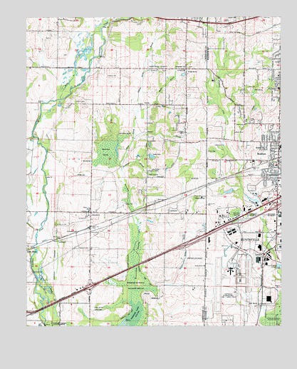
Greenbrier, AL USGS Topographic Map
Click on map above to begin viewing in our Map Viewer.

This topographic map contains these locations and features:
Feature Name Type Latitude Longitude GNIS ID View Map
Anderson CemeteryCemeteryN34.7151°W86.8686°113071View Map
Anderson CemeteryCemeteryN34.7265°W86.8353°113072View Map
Bailey CemeteryCemeteryN34.6990°W86.7811°146662View Map
Beaverdam CreekStreamN34.6251°W86.8269°113761View Map
Beaverdam SpringSpringN34.7028°W86.8296°113770View Map
Beaverdam SwampSwampN34.6579°W86.8215°113771View Map
Beaverdam SwampSwampN34.6955°W86.8343°113772View Map
Bethlehem ChurchChurchN34.6645°W86.8439°137798View Map
Betts CemeteryCemeteryN34.7218°W86.7661°114165View Map
Betts SpringSpringN34.7204°W86.7630°114167View Map
Betz School (historical)SchoolN34.7209°W86.7686°146690View Map
Bibb CemeteryCemeteryN34.6998°W86.7583°114203View Map
Bradford Health Services Huntsville Adult / Adolescent Treatment CenterHospitalN34.7243°W86.7834°2669256View Map
Burgreen GinPopulated PlaceN34.7290°W86.7964°115228View Map
Burgreen LakeReservoirN34.7268°W86.7978°137803View Map
Cedar Acres ChurchChurchN34.7070°W86.8008°137810View Map
City of MadisonCivilN34.7113°W86.7617°2404989View Map
Clift CemeteryCemeteryN34.7498°W86.7583°116265View Map
Donaldson CemeteryCemeteryN34.7490°W86.7978°163670View Map
Fletcher CemeteryCemeteryN34.7159°W86.8506°118419View Map
Fletchers Chapel Primitive Baptist ChurchChurchN34.6568°W86.8442°151771View Map
Glover CemeteryCemeteryN34.7298°W86.7953°163674View Map
GreenbrierPopulated PlaceN34.6709°W86.8436°119357View Map
Greenbrier Baptist ChurchChurchN34.6701°W86.8444°141113View Map
Greenbrier Church of ChristChurchN34.6693°W86.8458°141114View Map
Hardiman BranchStreamN34.6881°W86.8281°119715View Map
Holding CemeteryCemeteryN34.6418°W86.7600°120220View Map
Huntsville International Airport-Carl T Jones FieldAirportN34.6464°W86.7749°129501View Map
Jetport Municipal Golf CourseLocaleN34.6565°W86.7772°147018View Map
John J Jones CemeteryCemeteryN34.7349°W86.8565°2745926View Map
Jones - Donnell CemeteryCemeteryN34.6687°W86.8454°120547View Map
Jones Cemetery (historical)CemeteryN34.6409°W86.7675°157475View Map
Jones-Clay CemeteryCemeteryN34.7415°W86.8634°2745927View Map
Lake GaryReservoirN34.6938°W86.8135°118857View Map
Lake Gary DamDamN34.6918°W86.8133°132038View Map
Madison Baptist ChurchChurchN34.6965°W86.7508°147070View Map
Madison Fire and Rescue Station 3BuildingN34.7360°W86.7867°2683041View Map
Madison Middle SchoolSchoolN34.6976°W86.7506°147084View Map
Madison PointPopulated PlaceN34.7015°W86.7528°147086View Map
Manley CrossroadsLocaleN34.6604°W86.7908°147090View Map
Maple Grove Freewill Baptist ChurchChurchN34.6493°W86.7878°152219View Map
Maple Grove School (historical)SchoolN34.6501°W86.7878°138673View Map
MaplewoodPopulated PlaceN34.6981°W86.7583°122273View Map
Martin BranchStreamN34.7170°W86.8575°122319View Map
Mason Christian Methodist Episcopal ChapelChurchN34.6909°W86.7511°150953View Map
Mill CreekStreamN34.6895°W86.7692°122798View Map
Moore BranchStreamN34.6901°W86.8289°122991View Map
Mooresville DivisionCivilN34.6576°W86.8550°165851View Map
Moses Chapel Baptist ChurchChurchN34.7034°W86.7725°152387View Map
Moss SpringSpringN34.6916°W86.8434°123120View Map
Mount Pleasant School (historical)SchoolN34.6709°W86.8128°138676View Map
Mount Zion Primitive Baptist ChurchChurchN34.6340°W86.7608°152539View Map
New HavenPopulated PlaceN34.6334°W86.7614°156782View Map
New Haven CemeteryCemeteryN34.6329°W86.7617°147145View Map
OaklandPopulated PlaceN34.7293°W86.8069°137882View Map
Oakland Baptist ChurchChurchN34.7295°W86.8086°152752View Map
Oakland SpringSpringN34.7299°W86.8098°124152View Map
Oakland Spring BranchStreamN34.7120°W86.8200°124153View Map
Palmer CemeteryCemeteryN34.6920°W86.7842°152835View Map
ParkerPopulated PlaceN34.7145°W86.8153°156859View Map
Parker ChapelChurchN34.7137°W86.8108°152842View Map
Parker Church CemeteryCemeteryN34.7136°W86.8113°163688View Map
Parker School (historical)SchoolN34.7140°W86.8122°138683View Map
Peete CemeteryCemeteryN34.6762°W86.8106°124568View Map
Phillips TabernacleChurchN34.7434°W86.7700°152885View Map
Putnam Industrial ParkLocaleN34.6668°W86.7786°147215View Map
Quarter Lot CemeteryCemeteryN34.6662°W86.8606°125377View Map
Ragland CemeteryCemeteryN34.6740°W86.8269°125408View Map
Rolling WoodsPopulated PlaceN34.7240°W86.7517°147230View Map
Russell BranchStreamN34.6895°W86.8283°126024View Map
Saint Elizabeth Cumberland ChurchChurchN34.6945°W86.7542°147240View Map
Saint Peter African Methodist Episcopal ChurchChurchN34.6965°W86.7544°150956View Map
Segars Road ChurchChurchN34.6862°W86.8153°153365View Map
Segers Volunteer Fire and RescueBuildingN34.6889°W86.8159°2682642View Map
Sulcer SpringSpringN34.6325°W86.8374°127512View Map
Temple Baptist ChurchChurchN34.7290°W86.8106°153668View Map
Toney CemeteryCemeteryN34.7459°W86.7781°150059View Map
Tribble SpringSpringN34.7281°W86.7959°128068View Map
Waldo Chapel (historical)ChurchN34.7368°W86.7964°138703View Map
Washington CemeteryCemeteryN34.7068°W86.7719°128609View Map
West Madison Junior High SchoolSchoolN34.7212°W86.7508°128788View Map
Whitworth CemeteryCemeteryN34.6981°W86.7822°128933View Map
Wiggins CemeteryCemeteryN34.6398°W86.7519°128941View Map
Wild Hog SwampSwampN34.6705°W86.7722°128960View Map
Withers CemeteryCemeteryN34.6776°W86.7931°129142View Map
Withers SpringSpringN34.6767°W86.7925°129143View Map
Withers Spring BranchStreamN34.6409°W86.8114°129144View Map
Woodsides CemeteryCemeteryN34.6468°W86.8722°129217View Map

Note: Coordinates in the location and feature list above are referenced to NAD83 datum.


Copyright (C) 2008-2024 Ryan Niemi / Sunset Dynamics ... All Rights Reserved