TopoQuest Logo
Do you find TopoQuest useful?
Help keep TopoQuest running and adding new maps/features by donating!
Bitcoin:  19c7KJd3qBynnjoSw5npx9KScwjBe4ifkT
Litecoin:  LXs6TkuXGGXo1vDsWCkWVdjQX94eUKd6ui
Home View Maps Find Maps Find Places Resources & Links


Capshaw, Alabama Topographic Map

USGS Map Title: Capshaw, AL
USGS Map MRC: 34086G7
DRG (GeoTIFF) Download: o34086g7.tif


Neighboring USGS Topographic Map Quads:


  Elkmont, AL  
34086H8
 

  Ardmore, AL  
34086H7
 

  Toney, AL  
34086H6
 

  Athens, AL  
34086G8
 

  Capshaw, AL  
34086G7
 

  Jeff, AL  
34086G6
 

  Tanner, AL  
34086F8
 

  Greenbrier, AL  
34086F7
 

  Madison, AL  
34086F6


Map MRC Location:

N35°
W87°
N35°
W86°
H8 H7 H6 H5 H4 H3 H2 H1
G8 G7 G6 G5 G4 G3 G2 G1
F8 F7 F6 F5 F4 F3 F2 F1
E8 E7 E6 E5 E4 E3 E2 E1
D8 D7 D6 D5 D4 D3 D2 D1
C8 C7 C6 C5 C4 C3 C2 C1
B8 B7 B6 B5 B4 B3 B2 B1
A8 A7 A6 A5 A4 A3 A2 A1
N34°
W87°
N34°
W86°

Capshaw, AL USGS 1:24K Topographic Map Preview:
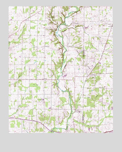
Capshaw, AL USGS Topographic Map
Click on map above to begin viewing in our Map Viewer.

This topographic map contains these locations and features:
Feature Name Type Latitude Longitude GNIS ID View Map
Bethel CemeteryCemeteryN34.7658°W86.8730°163665View Map
Bethel Church of ChristChurchN34.7654°W86.8731°114084View Map
Bowling BranchStreamN34.8456°W86.7786°114776View Map
Browning CemeteryCemeteryN34.8567°W86.7553°115003View Map
Camp HelenLocaleN34.7654°W86.8097°137807View Map
CapshawPopulated PlaceN34.7731°W86.7928°115608View Map
Capshaw Baptist ChurchChurchN34.7720°W86.7931°137808View Map
Capshaw Post OfficePost OfficeN34.7628°W86.7863°166629View Map
Capshaw School (historical)SchoolN34.7743°W86.8086°1700452View Map
Carroll CemeteryCemeteryN34.8709°W86.7664°115647View Map
Carter CemeteryCemeteryN34.8559°W86.7947°115666View Map
Center HillPopulated PlaceN34.8576°W86.7953°156162View Map
Center Hill CemeteryCemeteryN34.8740°W86.7836°115846View Map
Center Hill School (historical)SchoolN34.8579°W86.7911°138661View Map
Chriswood Golf CourseLocaleN34.8059°W86.8555°141171View Map
Church of ChristChurchN34.7709°W86.7922°137812View Map
ClarkdalePopulated PlaceN34.8073°W86.7728°116185View Map
Clarksdale Baptist ChurchChurchN34.8081°W86.7728°152897View Map
Coalton (historical)LocaleN34.8195°W86.7811°146804View Map
Community Baptist ChurchChurchN34.7829°W86.7631°146814View Map
CopelandPopulated PlaceN34.8348°W86.8319°137814View Map
Copeland BranchStreamN34.8298°W86.8442°137815View Map
Copeland Presbyterian ChurchChurchN34.8354°W86.8414°116605View Map
Copeland SchoolSchoolN34.8354°W86.8314°163928View Map
Copperrun BranchStreamN34.7698°W86.7992°116618View Map
Corinth Church of ChristChurchN34.8026°W86.8628°116645View Map
Country AcresPopulated PlaceN34.7537°W86.7953°137816View Map
Cummins CemeteryCemeteryN34.8351°W86.8011°116964View Map
Davis BranchStreamN34.7995°W86.7836°117104View Map
East LimestonePopulated PlaceN34.7809°W86.8328°137826View Map
East Limestone SchoolSchoolN34.7831°W86.8333°117781View Map
East Limestone Volunteer Fire DepartmentBuildingN34.7852°W86.8329°2682994View Map
Epps AirparkAirportN34.8647°W86.7701°129512View Map
Fairmount SchoolSchoolN34.8031°W86.8731°118125View Map
FairviewPopulated PlaceN34.8031°W86.8325°118131View Map
Fairview Baptist ChurchChurchN34.8023°W86.8319°137834View Map
Fairview Church CemeteryCemeteryN34.8020°W86.8322°163672View Map
Fletcher CemeteryCemeteryN34.7504°W86.7719°118420View Map
Grimett School (historical)SchoolN34.8031°W86.8328°1700454View Map
Hall CemeteryCemeteryN34.8622°W86.8282°119579View Map
Hammond CemeteryCemeteryN34.8159°W86.7550°157466View Map
Harding SpringSpringN34.8207°W86.8031°119720View Map
HarvestPopulated PlaceN34.8556°W86.7508°119829View Map
Harvest Census Designated PlaceCensusN34.8558°W86.7521°2402570View Map
Harvest School (historical)SchoolN34.8709°W86.7669°1700459View Map
Harvest Volunteer Fire Department Station 3BuildingN34.8162°W86.7627°2683401View Map
Hutchings CemeteryCemeteryN34.8445°W86.7686°157471View Map
Independent Church of ChristChurchN34.7873°W86.8153°137856View Map
Jenkins BranchStreamN34.7843°W86.7892°120839View Map
Johnson Junior High SchoolSchoolN34.8681°W86.8392°165457View Map
Joyner CemeteryCemeteryN34.8042°W86.7511°147028View Map
Kaufman BranchStreamN34.8398°W86.8742°151938View Map
Knox CreekStreamN34.7584°W86.8044°121279View Map
Leslie BranchStreamN34.8440°W86.8100°121504View Map
Lighthouse Baptist ChurchChurchN34.7540°W86.8500°154158View Map
Limestone Correctional FacilityBuildingN34.8120°W86.8047°141190View Map
Lockhart CemeteryCemeteryN34.8331°W86.7886°121946View Map
Love DitchStreamN34.8537°W86.7856°122056View Map
Macedonia Baptist ChurchChurchN34.7518°W86.7956°137867View Map
Martin CemeteryCemeteryN34.7531°W86.8544°152236View Map
McClellan CemeteryCemeteryN34.7890°W86.8011°122473View Map
McCully Mill (historical)LocaleN34.7743°W86.8642°138671View Map
Menefee CemeteryCemeteryN34.7749°W86.8683°122655View Map
Midway Baptist ChurchChurchN34.7654°W86.8678°141102View Map
Monrovia Fire Rescue Station 2BuildingN34.7965°W86.7720°2683393View Map
Nelson School (historical)SchoolN34.8181°W86.7964°137875View Map
Nelson SpringSpringN34.8317°W86.7858°123701View Map
New Zion Church (historical)ChurchN34.8676°W86.7911°1700456View Map
Nick Davis CemeteryCemeteryN34.8023°W86.8044°123946View Map
NorthwoodPopulated PlaceN34.7784°W86.7583°147160View Map
Pike CemeteryCemeteryN34.7520°W86.7697°124722View Map
Pine Grove Baptist ChurchChurchN34.7948°W86.7656°152921View Map
Pine Grove CemeteryCemeteryN34.7954°W86.7661°147196View Map
Pine SwampSwampN34.7976°W86.8428°124841View Map
Powers CemeteryCemeteryN34.8609°W86.7583°125231View Map
Romine LakeReservoirN34.7534°W86.7785°132044View Map
Romine Lake DamDamN34.7551°W86.7800°132043View Map
Sardis Springs School (historical)SchoolN34.8454°W86.8744°154162View Map
Smith CemeteryCemeteryN34.8117°W86.7639°157508View Map
Smith CemeteryCemeteryN34.7942°W86.7806°127011View Map
Thomas ChapelChurchN34.8081°W86.7675°147312View Map
Thomas School (historical)SchoolN34.7806°W86.8456°1700457View Map
Turner FordCrossingN34.8323°W86.8061°1700458View Map
Vasser-Pettus CemeteryCemeteryN34.8012°W86.7686°147344View Map
Wesley Chapel (historical)ChurchN34.7593°W86.8328°138705View Map
Wesley Chapel CemeteryCemeteryN34.7592°W86.8320°128744View Map

Note: Coordinates in the location and feature list above are referenced to NAD83 datum.


Copyright (C) 2008-2024 Ryan Niemi / Sunset Dynamics ... All Rights Reserved