TopoQuest Logo
Do you find TopoQuest useful?
Help keep TopoQuest running and adding new maps/features by donating!
Bitcoin:  19c7KJd3qBynnjoSw5npx9KScwjBe4ifkT
Litecoin:  LXs6TkuXGGXo1vDsWCkWVdjQX94eUKd6ui
Home View Maps Find Maps Find Places Resources & Links


Grifton, North Carolina Topographic Map

USGS Map Title: Grifton, NC
USGS Map MRC: 35077C4
DRG (GeoTIFF) Download: o35077c4.tif


Neighboring USGS Topographic Map Quads:


  Hookerton, NC  
35077D5
 

  Ayden, NC  
35077D4
 

  Gardnerville, NC  
35077D3
 

  Kinston, NC  
35077C5
 

  Grifton, NC  
35077C4
 

  Fort Barnwell, NC  
35077C3
 

  Rivermont, NC  
35077B5
 

  Dover, NC  
35077B4
 

  Cove City, NC  
35077B3


Map MRC Location:

N36°
W78°
N36°
W77°
H8 H7 H6 H5 H4 H3 H2 H1
G8 G7 G6 G5 G4 G3 G2 G1
F8 F7 F6 F5 F4 F3 F2 F1
E8 E7 E6 E5 E4 E3 E2 E1
D8 D7 D6 D5 D4 D3 D2 D1
C8 C7 C6 C5 C4 C3 C2 C1
B8 B7 B6 B5 B4 B3 B2 B1
A8 A7 A6 A5 A4 A3 A2 A1
N35°
W78°
N35°
W77°

Grifton, NC USGS 1:24K Topographic Map Preview:
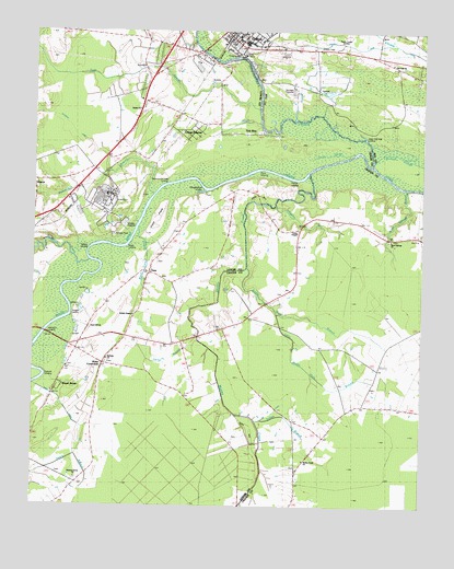
Grifton, NC USGS Topographic Map
Click on map above to begin viewing in our Map Viewer.

This topographic map contains these locations and features:
Feature Name Type Latitude Longitude GNIS ID View Map
Albrittons LandingLocaleN35.2968°W77.4947°1018785View Map
Alligator BranchStreamN35.3296°W77.4219°1024507View Map
Alligator CanalChannelN35.3482°W77.4858°1004608View Map
Alligator CanalCanalN35.3474°W77.4858°1024648View Map
Alum Springs BranchStreamN35.3341°W77.3802°1004534View Map
Alum Springs ChurchChurchN35.3202°W77.3850°1004536View Map
Beaverdam BranchStreamN35.3321°W77.4614°1004552View Map
Bectons Old Field LandingLocaleN35.3354°W77.4580°1023820View Map
Bethany ChurchChurchN35.2888°W77.4761°1004543View Map
Bethel ChurchChurchN35.3543°W77.4661°1004551View Map
Bone Gray BranchStreamN35.3232°W77.4664°1004547View Map
British ChapelChurchN35.3004°W77.4675°1004544View Map
Caswell LandingLocaleN35.2843°W77.4952°1019558View Map
Channel 7 CanalCanalN35.3721°W77.4016°1024645View Map
Clark FieldIslandN35.3252°W77.4602°1024651View Map
ClossPopulated PlaceN35.3132°W77.4625°1019705View Map
Contentnea CreekStreamN35.3404°W77.3889°983467View Map
Cox CanalCanalN35.2749°W77.4222°1024647View Map
Doughertys CoveBayN35.3335°W77.4458°1004549View Map
Eagle SwampStreamN35.3513°W77.4269°1023958View Map
Folley BranchStreamN35.2724°W77.4280°1024508View Map
Fort Barnwell Volunteer Fire DepartmentBuildingN35.3235°W77.4146°2639043View Map
GriftonPopulated PlaceN35.3727°W77.4375°1024010View Map
Grifton City HallBuildingN35.3729°W77.4358°1004532View Map
Grifton Pentecostal Holiness ChurchChurchN35.3707°W77.4197°2506143View Map
Grifton Police DepartmentBuildingN35.3742°W77.4392°2769721View Map
Grifton Post OfficePost OfficeN35.3740°W77.4376°1024976View Map
Grifton Rescue SquadBuildingN35.3729°W77.4353°2720348View Map
Grifton SchoolSchoolN35.3748°W77.4367°1007463View Map
Grifton United Methodist ChurchChurchN35.3737°W77.4343°2506144View Map
Grifton Volunteer Fire DepartmentBuildingN35.3742°W77.4392°1007462View Map
Grinnel SloughStreamN35.3427°W77.3886°986164View Map
Harrys BranchStreamN35.2943°W77.4469°1004540View Map
Hickory Grove ChurchChurchN35.2574°W77.4858°1004539View Map
Jacks SloughStreamN35.3432°W77.3969°1024650View Map
John Hill Mobile Home ParkPopulated PlaceN35.3136°W77.4440°2505479View Map
Jollys Old Field LandingLocaleN35.3482°W77.3914°1020973View Map
Lanes ChapelChurchN35.3221°W77.4147°1004535View Map
Little Snake Hole BranchStreamN35.3007°W77.4214°1004538View Map
Live Oak ChurchChurchN35.3668°W77.3850°1004533View Map
Mosley CreekStreamN35.3382°W77.4105°1024166View Map
Mosley Creek ChurchChurchN35.2627°W77.4122°1024654View Map
Nelson LandingLocaleN35.3171°W77.4830°1004546View Map
Oak BridgeBridgeN35.2954°W77.4964°1002653View Map
Pearce LandingLocaleN35.3354°W77.4164°1024210View Map
Plank LandingLocaleN35.3379°W77.4305°1021995View Map
Rhem CanalCanalN35.2713°W77.4847°1024649View Map
Royal AcresPopulated PlaceN35.2813°W77.4914°1004541View Map
Sand Hill ChurchChurchN35.2966°W77.4819°1004545View Map
Sand Hill Volunteer Fire DepartmentBuildingN35.2984°W77.4685°2638483View Map
Snake Hole BranchStreamN35.3127°W77.4314°1004537View Map
Stonyton CreekStreamN35.3168°W77.4825°995586View Map
Terrapin LandingLocaleN35.3007°W77.4691°1024347View Map
Tick BitePopulated PlaceN35.3482°W77.4308°1004550View Map
Town of GriftonCivilN35.3729°W77.4311°2406620View Map
Township of Contentnea NeckCivilN35.3627°W77.4899°1026874View Map
Township of Sand HillCivilN35.2787°W77.4690°1026881View Map
Tracey SwampStreamN35.2513°W77.4316°1024359View Map
Urban EstatesPopulated PlaceN35.3485°W77.4491°1024443View Map
West CrossroadsPopulated PlaceN35.2874°W77.4777°1004542View Map
West LandingLocaleN35.3193°W77.4686°1023169View Map
WITN-FM (Washington)TowerN35.3718°W77.4011°1025079View Map
WITN-TV (Washington)TowerN35.3718°W77.4011°1025093View Map
WNCT-FM (Greenville)TowerN35.3654°W77.3936°1025078View Map
WNCT-TV (Greenville)TowerN35.3716°W77.3983°1025094View Map

Note: Coordinates in the location and feature list above are referenced to NAD83 datum.


Copyright (C) 2008-2024 Ryan Niemi / Sunset Dynamics ... All Rights Reserved