TopoQuest Logo
Do you find TopoQuest useful?
Help keep TopoQuest running and adding new maps/features by donating!
Bitcoin:  19c7KJd3qBynnjoSw5npx9KScwjBe4ifkT
Litecoin:  LXs6TkuXGGXo1vDsWCkWVdjQX94eUKd6ui
Home View Maps Find Maps Find Places Resources & Links


Hagarville, Arkansas Topographic Map

USGS Map Title: Hagarville, AR
USGS Map MRC: 35093E3
DRG (GeoTIFF) Download: o35093e3.tif


Neighboring USGS Topographic Map Quads:


  Ozone, AR  
35093F4
 

  Rosetta, AR  
35093F3
 

  Fort Douglas, AR  
35093F2
 

  Ludwig, AR  
35093E4
 

  Hagarville, AR  
35093E3
 

  Treat, AR  
35093E2
 

  Clarksville, AR  
35093D4
 

  Knoxville, AR  
35093D3
 

  Lee Mountain, AR  
35093D2


Map MRC Location:

N36°
W94°
N36°
W93°
H8 H7 H6 H5 H4 H3 H2 H1
G8 G7 G6 G5 G4 G3 G2 G1
F8 F7 F6 F5 F4 F3 F2 F1
E8 E7 E6 E5 E4 E3 E2 E1
D8 D7 D6 D5 D4 D3 D2 D1
C8 C7 C6 C5 C4 C3 C2 C1
B8 B7 B6 B5 B4 B3 B2 B1
A8 A7 A6 A5 A4 A3 A2 A1
N35°
W94°
N35°
W93°

Hagarville, AR USGS 1:24K Topographic Map Preview:
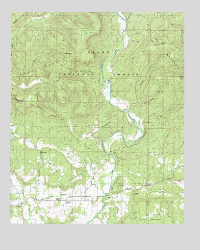
Hagarville, AR USGS Topographic Map
Click on map above to begin viewing in our Map Viewer.

This topographic map contains these locations and features:
Feature Name Type Latitude Longitude GNIS ID View Map
Adkins CemeteryCemeteryN35.5234°W93.3171°67127View Map
Annies ChapelChurchN35.5229°W93.2766°76173View Map
Annis Chapel CemeteryCemeteryN35.5223°W93.2760°65131View Map
Brown MountainSummitN35.5604°W93.3071°67128View Map
Chalybeate SpurRidgeN35.5662°W93.3507°71109View Map
Chronister Store (historical)LocaleN35.5115°W93.3663°71150View Map
Deevers BranchStreamN35.5120°W93.3557°67129View Map
Dry CreekStreamN35.5154°W93.3080°74336View Map
Granny CreekStreamN35.5120°W93.3071°71799View Map
Grassy Point CreekStreamN35.6167°W93.2516°67130View Map
HagarvillePopulated PlaceN35.5156°W93.3249°77102View Map
Hagarville Census Designated PlaceCensusN35.5151°W93.3335°2612126View Map
Hagarville East CemeteryCemeteryN35.5137°W93.3343°67131View Map
Hagarville MountainSummitN35.5292°W93.3246°67132View Map
Hagarville Post OfficePost OfficeN35.5159°W93.3277°84294View Map
Hagarville West CemeteryCemeteryN35.5138°W93.3379°74339View Map
Hagarville West CemeteryCemeteryN35.5144°W93.3385°67133View Map
Johnson County Rural Fire District 3BuildingN35.5140°W93.3532°2116637View Map
Johnson County Rural Fire District 3BuildingN35.5139°W93.3534°2116651View Map
Lees ChapelChurchN35.5270°W93.2588°74334View Map
Lees Chapel Assembly of God ChurchChurchN35.5267°W93.2591°78871View Map
Little Granny CreekStreamN35.5215°W93.2818°72396View Map
Little Minnow CreekStreamN35.5040°W93.3607°74342View Map
Little Sulphur CreekStreamN35.5704°W93.2855°72424View Map
Mikles CreekStreamN35.6209°W93.3532°74476View Map
Minnow Creek CemeteryCemeteryN35.5112°W93.3682°67134View Map
Murray Chapel SchoolSchoolN35.5742°W93.3030°72820View Map
Newton CemeteryCemeteryN35.5158°W93.3048°67135View Map
Peters BranchStreamN35.6245°W93.2916°74415View Map
Pilot KnobSummitN35.5870°W93.2513°73079View Map
Pine MountainRangeN35.5417°W93.3716°74416View Map
Poyner (historical)Populated PlaceN35.6120°W93.3707°65170View Map
Red Oak SchoolSchoolN35.5301°W93.2821°73258View Map
Russell CemeteryCemeteryN35.5676°W93.2910°67139View Map
Sally Ann HollowValleyN35.5856°W93.3082°74302View Map
Sally Ann HollowValleyN35.5862°W93.3085°67140View Map
Saul MountainSummitN35.5229°W93.2982°73485View Map
StrawberryPopulated PlaceN35.5479°W93.3543°73736View Map
Strawberry Assembly of God ChurchChurchN35.5437°W93.3543°65175View Map
Strawberry SchoolSchoolN35.5434°W93.3555°73735View Map
Sulphur CreekStreamN35.5648°W93.2910°73770View Map
Summerland SchoolSchoolN35.5340°W93.2516°73780View Map
Tater HillSummitN35.5181°W93.2855°73831View Map
The NarrowsGapN35.5406°W93.3046°73847View Map
Toms BranchStreamN35.5581°W93.2855°81382View Map
Township of HickeyCivilN35.5053°W93.2645°66754View Map
Township of PerryCivilN35.6242°W93.2905°66763View Map
Turkey HillSummitN35.5606°W93.2630°67141View Map
Woods MountainSummitN35.5865°W93.3499°74209View Map
Woods Mountain CemeteryCemeteryN35.6004°W93.3311°67142View Map
Woods Mountain SchoolSchoolN35.5826°W93.3485°74210View Map
Zadock (historical)Populated PlaceN35.5676°W93.3696°65181View Map

Note: Coordinates in the location and feature list above are referenced to NAD83 datum.


Copyright (C) 2008-2024 Ryan Niemi / Sunset Dynamics ... All Rights Reserved