TopoQuest Logo
Do you find TopoQuest useful?
Help keep TopoQuest running and adding new maps/features by donating!
Bitcoin:  19c7KJd3qBynnjoSw5npx9KScwjBe4ifkT
Litecoin:  LXs6TkuXGGXo1vDsWCkWVdjQX94eUKd6ui
Home View Maps Find Maps Find Places Resources & Links


Lee Mountain, Arkansas Topographic Map

USGS Map Title: Lee Mountain, AR
USGS Map MRC: 35093D2
DRG (GeoTIFF) Download: o35093d2.tif


Neighboring USGS Topographic Map Quads:


  Hagarville, AR  
35093E3
 

  Treat, AR  
35093E2
 

  Simpson, AR  
35093E1
 

  Knoxville, AR  
35093D3
 

  Lee Mountain, AR  
35093D2
 

  Dover, AR  
35093D1
 

  Delaware, AR  
35093C3
 

  Russellville West, AR  
35093C2
 

  Russellville East, AR  
35093C1


Map MRC Location:

N36°
W94°
N36°
W93°
H8 H7 H6 H5 H4 H3 H2 H1
G8 G7 G6 G5 G4 G3 G2 G1
F8 F7 F6 F5 F4 F3 F2 F1
E8 E7 E6 E5 E4 E3 E2 E1
D8 D7 D6 D5 D4 D3 D2 D1
C8 C7 C6 C5 C4 C3 C2 C1
B8 B7 B6 B5 B4 B3 B2 B1
A8 A7 A6 A5 A4 A3 A2 A1
N35°
W94°
N35°
W93°

Lee Mountain, AR USGS 1:24K Topographic Map Preview:
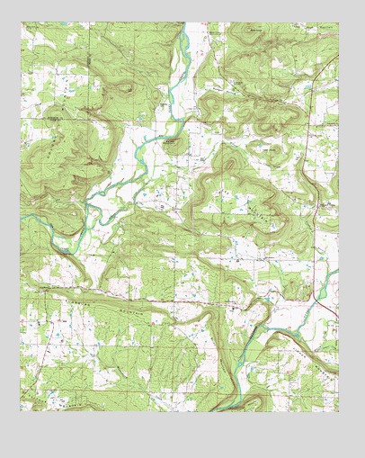
Lee Mountain, AR USGS Topographic Map
Click on map above to begin viewing in our Map Viewer.

This topographic map contains these locations and features:
Feature Name Type Latitude Longitude GNIS ID View Map
Adams CemeteryCemeteryN35.4979°W93.2482°45783View Map
AugsburgPopulated PlaceN35.4145°W93.2382°57291View Map
Augsburg CemeteryCemeteryN35.4129°W93.2421°64920View Map
Augsburg MountainSummitN35.4120°W93.2352°79125View Map
Bald KnobSummitN35.4976°W93.1607°46043View Map
Bayliss Rural Fire DepartmentBuildingN35.3991°W93.2376°2116118View Map
Booger HollowValleyN35.4751°W93.1857°46830View Map
Booger Hollow Community HallBuildingN35.4965°W93.1763°79306View Map
Booger Hollow TabernacleChurchN35.4812°W93.1677°79305View Map
Brown-Rye CemeteryCemeteryN35.4737°W93.1960°79304View Map
Chesser CemeteryCemeteryN35.3876°W93.1579°47731View Map
Colony MountainSummitN35.4556°W93.2399°79129View Map
Crooked BranchStreamN35.4192°W93.1291°48167View Map
Cumberland (historical)Populated PlaceN35.4084°W93.1655°79168View Map
Falerno (historical)Populated PlaceN35.4529°W93.2141°62026View Map
Famous (historical)Populated PlaceN35.4123°W93.2105°62022View Map
First Church of Pine MeadowsChurchN35.4242°W93.1546°79307View Map
House of Prayer ChurchChurchN35.4234°W93.1466°79137View Map
Howard CemeteryCemeteryN35.4751°W93.1474°77243View Map
Knoxville Extension Gas FieldOilfieldN35.3770°W93.2368°62019View Map
Lee MountainSummitN35.4398°W93.1577°58051View Map
Lindsey CemeteryCemeteryN35.4723°W93.1813°79140View Map
Linker CreekStreamN35.3954°W93.1321°77504View Map
Martin Township Volunteer Fire DepartmentBuildingN35.4676°W93.1374°2116770View Map
McCoy CreekStreamN35.3990°W93.1410°72586View Map
Mount Carmel Church (historical)ChurchN35.3937°W93.2407°62020View Map
Mountain Spring School (historical)SchoolN35.4065°W93.2099°62021View Map
New Hope Cumberland Presbyterian Church (historical)ChurchN35.4090°W93.1643°79130View Map
New Hope Gas FieldOilfieldN35.4751°W93.1613°62031View Map
North New Hope ChurchChurchN35.4098°W93.1655°79167View Map
Oak Grove School (historical)SchoolN35.3890°W93.1507°62028View Map
Parker MountainSummitN35.4617°W93.1893°58328View Map
Pentecostal ChurchChurchN35.4673°W93.1255°53276View Map
PineyPopulated PlaceN35.4406°W93.1902°78016View Map
Piney CemeteryCemeteryN35.4476°W93.1941°78018View Map
Pleasant Grove ChurchChurchN35.4642°W93.1368°53546View Map
Pleasant Grove ChurchChurchN35.4673°W93.1374°79151View Map
Pleasant Grove Church of ChristChurchN35.4784°W93.1341°79303View Map
Pleasant ValleyPopulated PlaceN35.4409°W93.1335°73136View Map
Pleasant Valley School (historical)SchoolN35.4331°W93.1349°62029View Map
Pollard CemeteryCemeteryN35.4520°W93.1268°53665View Map
Rushing ChurchChurchN35.4401°W93.1891°64930View Map
Shinn MountainSummitN35.4056°W93.1763°58617View Map
Silex School (historical)SchoolN35.4840°W93.2035°62027View Map
Sulphur MountainSummitN35.3756°W93.2402°79161View Map
Tater KnobSummitN35.4590°W93.1499°58736View Map
Tates Island Gas FieldOilfieldN35.4340°W93.2293°62024View Map
Tatetown (historical)Populated PlaceN35.4423°W93.2266°62025View Map
Township of BaylissCivilN35.4010°W93.2367°69697View Map
Township of MartinCivilN35.4862°W93.1830°69710View Map
Walnut Valley School (historical)SchoolN35.4545°W93.1524°62030View Map
Wilson CreekStreamN35.4409°W93.2238°56440View Map
Zion Lutheran Church of AugsburgChurchN35.4131°W93.2418°62023View Map

Note: Coordinates in the location and feature list above are referenced to NAD83 datum.


Copyright (C) 2008-2024 Ryan Niemi / Sunset Dynamics ... All Rights Reserved