TopoQuest Logo
Do you find TopoQuest useful?
Help keep TopoQuest running and adding new maps/features by donating!
Bitcoin:  19c7KJd3qBynnjoSw5npx9KScwjBe4ifkT
Litecoin:  LXs6TkuXGGXo1vDsWCkWVdjQX94eUKd6ui
Home View Maps Find Maps Find Places Resources & Links


Haystack Butte, Arizona Topographic Map

USGS Map Title: Haystack Butte, AZ
USGS Map MRC: 33110F6
DRG (GeoTIFF) Download: o33110f6.tif


Neighboring USGS Topographic Map Quads:


  Sombrero Peak, AZ  
33110G7
 

  Picacho Colorado, AZ  
33110G6
 

  Mule Hoof Bend, AZ  
33110G5
 

  Dagger Peak, AZ  
33110F7
 

  Haystack Butte, AZ  
33110F6
 

  Chrysotile, AZ  
33110F5
 

  Rockinstraw Mountain, AZ  
33110E7
 

  Chrome Butte, AZ  
33110E6
 

  Sevenmile Mountains, AZ  
33110E5


Map MRC Location:

N34°
W111°
N34°
W110°
H8 H7 H6 H5 H4 H3 H2 H1
G8 G7 G6 G5 G4 G3 G2 G1
F8 F7 F6 F5 F4 F3 F2 F1
E8 E7 E6 E5 E4 E3 E2 E1
D8 D7 D6 D5 D4 D3 D2 D1
C8 C7 C6 C5 C4 C3 C2 C1
B8 B7 B6 B5 B4 B3 B2 B1
A8 A7 A6 A5 A4 A3 A2 A1
N33°
W111°
N33°
W110°

Haystack Butte, AZ USGS 1:24K Topographic Map Preview:
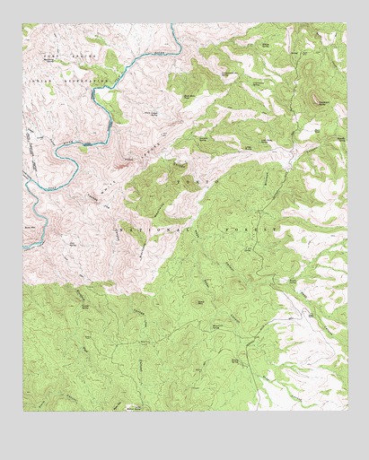
Haystack Butte, AZ USGS Topographic Map
Click on map above to begin viewing in our Map Viewer.

This topographic map contains these locations and features:
Feature Name Type Latitude Longitude GNIS ID View Map
Adobe RanchLocaleN33.6556°W110.6387°25529View Map
Barrel SpringSpringN33.7170°W110.6684°39246View Map
Bear Cub SpringSpringN33.6681°W110.6429°39248View Map
Black Mesa TankReservoirN33.7263°W110.6887°26410View Map
Black MountainSummitN33.6601°W110.6837°26419View Map
Blackie SpringSpringN33.7001°W110.6757°39273View Map
Blackjack MountainsSummitN33.6876°W110.7007°26458View Map
Blackjack WashStreamN33.6792°W110.7440°26465View Map
Bronson CanyonValleyN33.6973°W110.6790°26769View Map
Bronson SpringSpringN33.7130°W110.6264°26770View Map
Bronson TankReservoirN33.6999°W110.6305°2062269View Map
Brushy SpringSpringN33.6411°W110.6675°26841View Map
Brushy SpringSpringN33.6867°W110.6437°39298View Map
Butte TankReservoirN33.7462°W110.6646°39306View Map
Clay SpringSpringN33.6789°W110.7329°27690View Map
Cottonwood Box SpringSpringN33.7336°W110.6740°27997View Map
Cottonwood SpringSpringN33.7298°W110.6622°28038View Map
Division SpringSpringN33.7133°W110.6825°28496View Map
Freezeout SpringSpringN33.7410°W110.6736°39443View Map
Granite SpringSpringN33.6590°W110.7281°29494View Map
Hackberry SpringSpringN33.7381°W110.7384°29672View Map
Haystack ButteSummitN33.7239°W110.6371°29810View Map
Haystack Butte HeadquartersLocaleN33.7417°W110.6429°44994View Map
Headquarter SpringSpringN33.7403°W110.6449°39497View Map
Hess CanyonValleyN33.7153°W110.7165°29907View Map
Hess CreekStreamN33.7164°W110.7162°42766View Map
Hidden TankReservoirN33.7095°W110.6687°39503View Map
J U SpringSpringN33.6770°W110.6626°30451View Map
Little ButteSummitN33.7098°W110.6651°31043View Map
Little Butte SpringSpringN33.7117°W110.6592°31044View Map
Little Walnut SpringSpringN33.6260°W110.7051°31144View Map
Lower Corral CanyonValleyN33.6998°W110.7479°31345View Map
Lower Corral RapidRapidsN33.6994°W110.7481°2061147View Map
Monument SpringSpringN33.6516°W110.6777°31983View Map
Nesbitt SpringSpringN33.6945°W110.6451°39656View Map
No Name SpringSpringN33.6596°W110.6552°39659View Map
Pancho SpringSpringN33.6669°W110.6485°32654View Map
Sanders SpringSpringN33.7417°W110.6340°39772View Map
Sedal CanyonValleyN33.6806°W110.6840°34240View Map
Shorty Camp SpringSpringN33.6645°W110.6340°39789View Map
Steer Pasture WellWellN33.6401°W110.6401°39812View Map
Steer TankReservoirN33.7152°W110.6385°34822View Map
The Maze RapidRapidsN33.6923°W110.7453°2061145View Map
Upper Corral CanyonValleyN33.7089°W110.7387°35679View Map
White LedgesCliffN33.7031°W110.7096°36083View Map
White Ledges SpringSpringN33.7210°W110.6981°36084View Map
Willow SpringSpringN33.6548°W110.6368°39885View Map
Willow SpringSpringN33.7435°W110.6581°36245View Map
Willow SpringSpringN33.7437°W110.6582°36248View Map
Yankee Joe CanyonValleyN33.6970°W110.7354°36434View Map
Yankee Joe SeepSpringN33.6662°W110.7145°39897View Map
Yankee Joe TankReservoirN33.6872°W110.7266°40801View Map
Yellowjacket SpringSpringN33.7184°W110.6590°39900View Map

Note: Coordinates in the location and feature list above are referenced to NAD83 datum.


Copyright (C) 2008-2024 Ryan Niemi / Sunset Dynamics ... All Rights Reserved