TopoQuest Logo
Do you find TopoQuest useful?
Help keep TopoQuest running and adding new maps/features by donating!
Bitcoin:  19c7KJd3qBynnjoSw5npx9KScwjBe4ifkT
Litecoin:  LXs6TkuXGGXo1vDsWCkWVdjQX94eUKd6ui
Home View Maps Find Maps Find Places Resources & Links


Sombrero Peak, Arizona Topographic Map

USGS Map Title: Sombrero Peak, AZ
USGS Map MRC: 33110G7
DRG (GeoTIFF) Download: o33110g7.tif


Neighboring USGS Topographic Map Quads:


  McFadden Peak, AZ  
33110H8
 

  Rock House, AZ  
33110H7
 

  Double Buttes, AZ  
33110H6
 

  Aztec Peak, AZ  
33110G8
 

  Sombrero Peak, AZ  
33110G7
 

  Picacho Colorado, AZ  
33110G6
 

  Meddler Wash, AZ  
33110F8
 

  Dagger Peak, AZ  
33110F7
 

  Haystack Butte, AZ  
33110F6


Map MRC Location:

N34°
W111°
N34°
W110°
H8 H7 H6 H5 H4 H3 H2 H1
G8 G7 G6 G5 G4 G3 G2 G1
F8 F7 F6 F5 F4 F3 F2 F1
E8 E7 E6 E5 E4 E3 E2 E1
D8 D7 D6 D5 D4 D3 D2 D1
C8 C7 C6 C5 C4 C3 C2 C1
B8 B7 B6 B5 B4 B3 B2 B1
A8 A7 A6 A5 A4 A3 A2 A1
N33°
W111°
N33°
W110°

Sombrero Peak, AZ USGS 1:24K Topographic Map Preview:
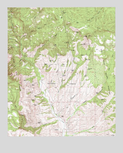
Sombrero Peak, AZ USGS Topographic Map
Click on map above to begin viewing in our Map Viewer.

This topographic map contains these locations and features:
Feature Name Type Latitude Longitude GNIS ID View Map
BadlandsAreaN33.7570°W110.8187°39242View Map
Banning WashStreamN33.7692°W110.8173°25952View Map
Bermuda Falls SpringSpringN33.8557°W110.8413°39256View Map
Bladder CanyonValleyN33.7625°W110.8084°26472View Map
Bladder SpringSpringN33.7918°W110.7703°39274View Map
Boulder SpringSpringN33.8138°W110.7990°39283View Map
Bronco CanyonValleyN33.8214°W110.8471°26765View Map
Bronco TankReservoirN33.8309°W110.8084°39293View Map
Brower TankReservoirN33.8473°W110.8201°39294View Map
Bull CanyonValleyN33.7653°W110.8159°26956View Map
Cane SpringSpringN33.8042°W110.8546°2061040View Map
Cement Dam TankReservoirN33.8339°W110.8507°39330View Map
Cherry Number One TankReservoirN33.8528°W110.8623°39342View Map
Cherry Number Three TankReservoirN33.8645°W110.8685°39343View Map
Cherry Number Two TankReservoirN33.8584°W110.8632°39344View Map
Cold Spring CanyonValleyN33.8348°W110.8601°27800View Map
Cook RanchLocaleN33.7573°W110.8076°27871View Map
Cooper ForksStreamN33.8428°W110.8612°27891View Map
Cottonwood SpringSpringN33.8096°W110.8123°39381View Map
Deep CreekStreamN33.7653°W110.8159°28363View Map
Deep Creek TankReservoirN33.7945°W110.8646°39404View Map
Devils ChasmValleyN33.8262°W110.8562°28440View Map
Dripping SpringSpringN33.7857°W110.7672°39419View Map
East Fork SpringSpringN33.8288°W110.7903°39429View Map
Ellison RanchLocaleN33.8042°W110.8387°28885View Map
Flying H RanchLocaleN33.7892°W110.8318°29081View Map
Gila CountyCivilN33.7997°W110.8117°40471View Map
Granite Basin SpringSpringN33.8167°W110.7812°39469View Map
Hackberry SpringSpringN33.7639°W110.8409°39483View Map
Half Barrel SpringSpringN33.8505°W110.7928°39490View Map
Hinton CreekStreamN33.8678°W110.8721°29001View Map
Hog MountainSummitN33.8389°W110.8187°30023View Map
Hog Mountain SpringSpringN33.8392°W110.8323°39507View Map
J Z Rogers SpringSpringN33.7804°W110.8422°39539View Map
Javelina SpringSpringN33.7903°W110.8423°39546View Map
Kendrick SpringSpringN33.7852°W110.8449°39555View Map
Leisure CanyonValleyN33.7970°W110.8293°30940View Map
Leisure Canyon TrailheadLocaleN33.7967°W110.8296°42666View Map
Leisure SpringSpringN33.8153°W110.8184°39562View Map
Little East Fork SpringSpringN33.8217°W110.7898°39567View Map
Little Sombrero PeakSummitN33.8392°W110.7854°31125View Map
Lone Pine DivideRidgeN33.8714°W110.8123°31209View Map
Mesa TankReservoirN33.7697°W110.8733°31729View Map
Middle Trap SpringSpringN33.8145°W110.8451°39623View Map
Moody PointSummitN33.8075°W110.8746°31986View Map
Moonshine GulchValleyN33.8398°W110.8029°31995View Map
Moonshine TankReservoirN33.8367°W110.7982°39637View Map
North Cooper Fork TankReservoirN33.8650°W110.8565°39660View Map
North Fork Cooper ForksStreamN33.8553°W110.8426°32363View Map
Oak SpringSpringN33.8332°W110.8003°39664View Map
Peach FlatFlatN33.8639°W110.8134°32751View Map
Peach Flat TankReservoirN33.8709°W110.8251°39689View Map
Pottery PointSummitN33.7664°W110.8093°33157View Map
Primrose SpringSpringN33.7998°W110.8479°39713View Map
Pueblo CanyonValleyN33.8395°W110.8607°33216View Map
Quail SpringSpringN33.8197°W110.8119°39718View Map
Quail Spring CanyonValleyN33.7987°W110.8140°39719View Map
Quell Spring CanyonValleyN33.7817°W110.8254°33289View Map
Rim-Moody Point TrailTrailN33.8042°W110.8734°39741View Map
Shack TankReservoirN33.7580°W110.8682°39785View Map
Sheep WashStreamN33.7503°W110.8098°34354View Map
Short Chops CanyonValleyN33.8117°W110.8371°34390View Map
Soldier Camp WashStreamN33.7967°W110.7634°34617View Map
Sombrero Butte TankReservoirN33.8547°W110.7862°39805View Map
Sombrero PeakSummitN33.8473°W110.7826°34634View Map
South Copper Fork TankReservoirN33.8565°W110.8284°39806View Map
South Fork Cooper ForksStreamN33.8553°W110.8426°34657View Map
Sycamore SpringSpringN33.8181°W110.8340°39825View Map
West Fork Oak CreekStreamN33.7817°W110.8254°35990View Map
Wild Cow TankReservoirN33.8606°W110.7973°39882View Map
Willow SpringSpringN33.8606°W110.7921°36249View Map
Yellow Jacket SpringSpringN33.8232°W110.8272°36458View Map
Yellow Jacket SpringSpringN33.8223°W110.8268°39899View Map

Note: Coordinates in the location and feature list above are referenced to NAD83 datum.


Copyright (C) 2008-2024 Ryan Niemi / Sunset Dynamics ... All Rights Reserved