TopoQuest Logo
Do you find TopoQuest useful?
Help keep TopoQuest running and adding new maps/features by donating!
Bitcoin:  19c7KJd3qBynnjoSw5npx9KScwjBe4ifkT
Litecoin:  LXs6TkuXGGXo1vDsWCkWVdjQX94eUKd6ui
Home View Maps Find Maps Find Places Resources & Links


Hickory, Louisiana Topographic Map

USGS Map Title: Hickory, LA
USGS Map MRC: 30089D7
DRG (GeoTIFF) Download: o30089d7.tif


Neighboring USGS Topographic Map Quads:


  Bush, LA  
30089E8
 

  Industrial, MS  
30089E7
 

  Picayune, MS  
30089E6
 

  Saint Tammany, LA  
30089D8
 

  Hickory, LA  
30089D7
 

  Nicholson, MS  
30089D6
 

  Lacombe, LA  
30089C8
 

  Slidell, LA  
30089C7
 

  Haaswood, LA  
30089C6


Map MRC Location:

N31°
W90°
N31°
W89°
H8 H7 H6 H5 H4 H3 H2 H1
G8 G7 G6 G5 G4 G3 G2 G1
F8 F7 F6 F5 F4 F3 F2 F1
E8 E7 E6 E5 E4 E3 E2 E1
D8 D7 D6 D5 D4 D3 D2 D1
C8 C7 C6 C5 C4 C3 C2 C1
B8 B7 B6 B5 B4 B3 B2 B1
A8 A7 A6 A5 A4 A3 A2 A1
N30°
W90°
N30°
W89°

Hickory, LA USGS 1:24K Topographic Map Preview:
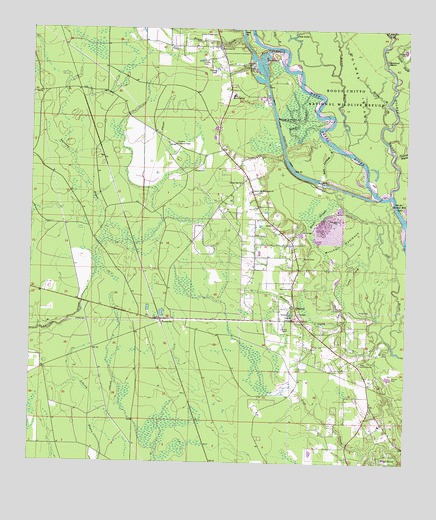
Hickory, LA USGS Topographic Map
Click on map above to begin viewing in our Map Viewer.

This topographic map contains these locations and features:
Feature Name Type Latitude Longitude GNIS ID View Map
AudubonPopulated PlaceN30.4091°W89.7840°1628842View Map
Audubon CreekStreamN30.4116°W89.7576°2054456View Map
Austin CemeteryCemeteryN30.4343°W89.7845°559804View Map
Bark Landing RiverStreamN30.4655°W89.7745°559823View Map
Bear Island (historical)IslandN30.4977°W89.8023°1628859View Map
Bennet BayouStreamN30.4660°W89.7698°560147View Map
Bogue Chitto National Wildlife RefugeReserveN30.4813°W89.7690°1958396View Map
Charter Oak CemeteryCemeteryN30.4532°W89.8022°1628884View Map
Charter Oak ChurchChurchN30.4557°W89.8059°560406View Map
Charter Oak Missionary ChurchChurchN30.4535°W89.8020°560407View Map
Church of God of ProphecyChurchN30.3856°W89.7634°2601680View Map
Creekside Junior High SchoolSchoolN30.3823°W89.7659°2493562View Map
Doghead IslandIslandN30.4913°W89.7573°560635View Map
Ernest SloughStreamN30.4724°W89.7795°560713View Map
Evans CreekStreamN30.4971°W89.8059°560719View Map
Evans Creek CemeteryCemeteryN30.4991°W89.8148°560720View Map
Evans Creek ChurchChurchN30.4949°W89.8140°560721View Map
FlorenvillePopulated PlaceN30.4166°W89.8317°560767View Map
Gill BayouStreamN30.4980°W89.7901°560829View Map
Henry Talley CemeteryCemeteryN30.4041°W89.7648°1628918View Map
Heritage Bible ChurchChurchN30.3837°W89.7649°2601896View Map
HickoryPopulated PlaceN30.4163°W89.7851°560961View Map
Hickory CemeteryCemeteryN30.4160°W89.7859°1628921View Map
Hickory CreekStreamN30.4146°W89.7573°560962View Map
Hickory Lookout TowerTowerN30.4671°W89.8276°560964View Map
Holmes BayouStreamN30.4532°W89.7551°560983View Map
Immanuel ChurchChurchN30.4255°W89.7884°1627321View Map
Little Broadaxe BayouStreamN30.4160°W89.7501°1627505View Map
Little Holmes BayouStreamN30.4732°W89.7573°1627519View Map
Lock Number OneDamN30.4560°W89.7792°1627552View Map
Maple SloughLakeN30.4436°W89.7791°1627608View Map
Mitchell HammockIslandN30.4385°W89.7720°1627676View Map
Moran CemeteryCemeteryN30.4593°W89.8213°1627687View Map
Parish Governing Authority District 6CivilN30.4959°W89.8563°1930158View Map
Pats HammockIslandN30.4941°W89.7970°1627875View Map
Pats LakeLakeN30.4980°W89.7890°1627876View Map
Pearl Hickory ChurchChurchN30.4035°W89.7651°1627885View Map
Pearl River CanalCanalN30.4699°W89.7928°1627888View Map
Pearl River Canal Pool Number OneReservoirN30.4719°W89.7934°1628763View Map
Pearl River United Methodist ChurchChurchN30.3835°W89.7651°2602569View Map
Pine Grove ChurchChurchN30.4019°W89.7859°1627926View Map
Saint Tammany Parish Fire District 7 Station 4BuildingN30.4126°W89.7810°2691815View Map
Saints Peter and Paul Catholic ChurchChurchN30.3866°W89.7577°2602777View Map
Sixth Ward Elementary SchoolSchoolN30.4812°W89.8082°1629026View Map
Smith CemeteryCemeteryN30.4905°W89.8195°1628245View Map
Spencer Mill LakeLakeN30.4487°W89.7506°1628275View Map
Toms FieldFlatN30.4294°W89.7676°1628371View Map
Ward SixCivilN30.4435°W89.8028°1628630View Map
Welch CemeteryCemeteryN30.4888°W89.8037°1628457View Map
West BayouStreamN30.4871°W89.7742°1628464View Map

Note: Coordinates in the location and feature list above are referenced to NAD83 datum.


Copyright (C) 2008-2024 Ryan Niemi / Sunset Dynamics ... All Rights Reserved