TopoQuest Logo
Do you find TopoQuest useful?
Help keep TopoQuest running and adding new maps/features by donating!
Bitcoin:  19c7KJd3qBynnjoSw5npx9KScwjBe4ifkT
Litecoin:  LXs6TkuXGGXo1vDsWCkWVdjQX94eUKd6ui
Home View Maps Find Maps Find Places Resources & Links


Lacombe, Louisiana Topographic Map

USGS Map Title: Lacombe, LA
USGS Map MRC: 30089C8
DRG (GeoTIFF) Download: o30089c8.tif


Neighboring USGS Topographic Map Quads:


  Covington, LA  
30090D1
 

  Saint Tammany, LA  
30089D8
 

  Hickory, LA  
30089D7
 

  Mandeville, LA  
30090C1
 

  Lacombe, LA  
30089C8
 

  Slidell, LA  
30089C7
 

  Spanish Fort NE, LA  
30090B1
 

  South Point, LA  
30089B8
 

  North Shore, LA  
30089B7


Map MRC Location:

N31°
W90°
N31°
W89°
H8 H7 H6 H5 H4 H3 H2 H1
G8 G7 G6 G5 G4 G3 G2 G1
F8 F7 F6 F5 F4 F3 F2 F1
E8 E7 E6 E5 E4 E3 E2 E1
D8 D7 D6 D5 D4 D3 D2 D1
C8 C7 C6 C5 C4 C3 C2 C1
B8 B7 B6 B5 B4 B3 B2 B1
A8 A7 A6 A5 A4 A3 A2 A1
N30°
W90°
N30°
W89°

Lacombe, LA USGS 1:24K Topographic Map Preview:
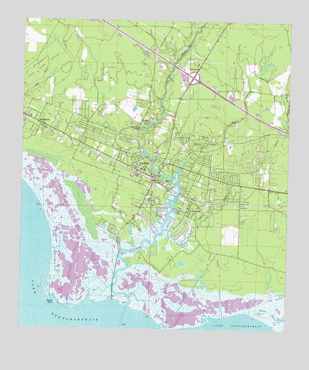
Lacombe, LA USGS Topographic Map
Click on map above to begin viewing in our Map Viewer.

This topographic map contains these locations and features:
Feature Name Type Latitude Longitude GNIS ID View Map
A To Z PreschoolSchoolN30.3085°W89.8882°2600028View Map
Bayou CochonStreamN30.2719°W89.9548°1629358View Map
Bayou Des MatsLakeN30.2939°W89.9798°1628952View Map
Bayou Lacombe Lighthouse (historical)LocaleN30.2544°W89.9503°1628849View Map
Bayou Lacombe Middle SchoolSchoolN30.3152°W89.9439°1628848View Map
Bayou LaurierLakeN30.2672°W89.9576°1629362View Map
Beacon Behavioral Hospital NorthshoreHospitalN30.3576°W89.9156°2601009View Map
Big BranchPopulated PlaceN30.3338°W89.9929°560170View Map
Big Branch BayouStreamN30.3108°W89.9267°560172View Map
Carmel ConventChurchN30.3352°W89.9423°560364View Map
Chahta - Ima Elementary SchoolSchoolN30.3125°W89.9462°1628881View Map
Chahta-Ima High SchoolSchoolN30.3121°W89.9462°560391View Map
Cousin CemeteryCemeteryN30.3285°W89.9142°560501View Map
Cypress BayouStreamN30.2905°W89.9328°560567View Map
Dixie Ranch Lookout TowerTowerN30.3460°W89.8751°560631View Map
First Baptist ChurchChurchN30.3166°W89.9491°2601741View Map
Forest Glen (historical)Populated PlaceN30.3252°W89.9731°1628905View Map
Forest Glen School (historical)SchoolN30.3263°W89.9573°1628906View Map
Goose PointCapeN30.2602°W89.9834°560851View Map
Holy Redeemer CollegeSchoolN30.3219°W89.9376°560989View Map
Huey P Long Fish Hatchery DamDamN30.3319°W89.9501°1628804View Map
Hygeia Health CampLocaleN30.3038°W89.8792°1628929View Map
Interchange 74CrossingN30.3521°W89.9203°1628667View Map
James Todd CemeteryCemeteryN30.3285°W89.9131°1628930View Map
Kingdom Hall of Jehovahs WitnessesChurchN30.3290°W89.9306°2602127View Map
LacombePopulated PlaceN30.3135°W89.9431°1627418View Map
Lacombe - Mandeville Head Start SchoolSchoolN30.3179°W89.9554°2600232View Map
Lacombe BayouStreamN30.2594°W89.9492°1627419View Map
Lacombe Census Designated PlaceCensusN30.3140°W89.9310°2403181View Map
Lacombe Post OfficePost OfficeN30.3162°W89.9484°1632277View Map
Lacombe United Methodist ChurchChurchN30.3147°W89.9426°2602156View Map
Lafrere CemeteryCemeteryN30.3121°W89.9369°1627422View Map
Living Word Assembly ChurchChurchN30.3223°W89.9674°2602210View Map
Lone Hill ChurchChurchN30.3021°W89.9403°1627556View Map
Lourdes ChurchChurchN30.3321°W89.9465°1627572View Map
North Shore Unitarian Universalist ChurchChurchN30.3581°W89.9234°2602506View Map
OaklawnPopulated PlaceN30.2988°W89.9212°1627810View Map
Parish Governing Authority District 7CivilN30.3099°W89.9880°1930210View Map
Point du ChienCapeN30.2502°W89.8778°1627947View Map
Sacred Heart ChurchChurchN30.3102°W89.9364°2602360View Map
Saint John of the Cross Catholic ChurchChurchN30.3171°W89.8913°2602655View Map
Saint Tammany Parish Fire District 3 Station 31BuildingN30.3113°W89.9392°2332576View Map
Saint Tammany Parish Fire District 3 Station 32BuildingN30.3116°W89.9127°2332715View Map
Saint Tammany Parish Fire District 3 Station 33BuildingN30.3593°W89.9150°2691783View Map
Saint Tammany Parish Library Lacombe BranchBuildingN30.3133°W89.9417°2603141View Map
Saint Tammany Parish Police Jury BarnBuildingN30.3459°W89.9413°2334087View Map
Saint Tammany State Game RefugeParkN30.2983°W89.9881°1629021View Map
Seghors CemeteryCemeteryN30.3182°W89.9362°1629024View Map
Southern Natural Gas Company Seaplane BaseAirportN30.2808°W89.9542°1632795View Map
Timberland Trailer ParkPopulated PlaceN30.2945°W89.8964°2600941View Map
Toomer Memorial CemeteryCemeteryN30.3319°W89.9431°1629048View Map
Village Lutheran Church of LacombeChurchN30.3121°W89.9161°2602950View Map
Ward SevenCivilN30.3127°W89.9276°1628631View Map
Williams CemeteryCemeteryN30.3105°W89.9326°1628507View Map

Note: Coordinates in the location and feature list above are referenced to NAD83 datum.


Copyright (C) 2008-2024 Ryan Niemi / Sunset Dynamics ... All Rights Reserved