TopoQuest Logo
Do you find TopoQuest useful?
Help keep TopoQuest running and adding new maps/features by donating!
Bitcoin:  19c7KJd3qBynnjoSw5npx9KScwjBe4ifkT
Litecoin:  LXs6TkuXGGXo1vDsWCkWVdjQX94eUKd6ui
Home View Maps Find Maps Find Places Resources & Links


Holla Bend, Arkansas Topographic Map

USGS Map Title: Holla Bend, AR
USGS Map MRC: 35093B1
DRG (GeoTIFF) Download: o35093b1.tif


Neighboring USGS Topographic Map Quads:


  Russellville West, AR  
35093C2
 

  Russellville East, AR  
35093C1
 

  Moreland, AR  
35092C8
 

  Dardanelle, AR  
35093B2
 

  Holla Bend, AR  
35093B1
 

  Atkins, AR  
35092B8
 

  Ola, AR  
35093A2
 

  Casa, AR  
35093A1
 

  Adona, AR  
35092A8


Map MRC Location:

N36°
W94°
N36°
W93°
H8 H7 H6 H5 H4 H3 H2 H1
G8 G7 G6 G5 G4 G3 G2 G1
F8 F7 F6 F5 F4 F3 F2 F1
E8 E7 E6 E5 E4 E3 E2 E1
D8 D7 D6 D5 D4 D3 D2 D1
C8 C7 C6 C5 C4 C3 C2 C1
B8 B7 B6 B5 B4 B3 B2 B1
A8 A7 A6 A5 A4 A3 A2 A1
N35°
W94°
N35°
W93°

Holla Bend, AR USGS 1:24K Topographic Map Preview:
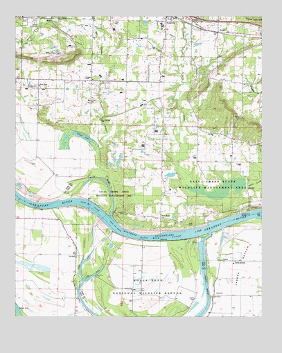
Holla Bend, AR USGS Topographic Map
Click on map above to begin viewing in our Map Viewer.

This topographic map contains these locations and features:
Feature Name Type Latitude Longitude GNIS ID View Map
Bethany Church (historical)ChurchN35.2115°W93.0505°62126View Map
Bethany School (historical)SchoolN35.2112°W93.0505°62125View Map
BethelPopulated PlaceN35.2490°W93.1091°57365View Map
Bethel CemeteryCemeteryN35.2487°W93.1052°83592View Map
Bethel Church (historical)ChurchN35.2495°W93.1074°62122View Map
Carden Bottom ChurchChurchN35.1331°W93.0260°79298View Map
Carden BottomsPopulated PlaceN35.1484°W93.0138°76531View Map
City of PottsvilleCivilN35.2318°W93.0635°2404563View Map
Coopers Store (historical)LocaleN35.1431°W93.0949°70218View Map
Dunn Springs CemeteryCemeteryN35.2067°W93.0821°83598View Map
Flagg LakeLakeN35.2002°W93.0911°74838View Map
FowlerPopulated PlaceN35.1484°W93.0202°57770View Map
Galla Creek State Wildlife Lake DamDamN35.1806°W93.0080°81025View Map
Galla Creek State Wildlife Management AreaParkN35.1801°W93.0243°49313View Map
Galla Creek Wildlife LakeReservoirN35.1783°W93.0206°81026View Map
Holla BendLakeN35.1827°W93.0825°74899View Map
Holla BendPopulated PlaceN35.1662°W93.0518°57060View Map
Holla Bend CutoffChannelN35.1581°W93.0513°50191View Map
Holla Bend National Wildlife RefugeParkN35.1400°W93.0603°50192View Map
Howells BendBendN35.1643°W93.0949°70221View Map
Interstate 88CrossingN35.2498°W93.0349°59007View Map
Jones LakeReservoirN35.2384°W93.0352°80984View Map
Jones Lake DamDamN35.2384°W93.0352°80983View Map
Lake IrvinReservoirN35.2179°W93.1205°79723View Map
Lake Irvin DamDamN35.2168°W93.1202°79722View Map
LakeviewPopulated PlaceN35.1340°W93.0232°58039View Map
Lakeview School (historical)SchoolN35.1340°W93.0252°67897View Map
Lodge LakeLakeN35.1426°W93.0849°79301View Map
Long LakeLakeN35.1415°W93.0867°79302View Map
Luther LakeLakeN35.1309°W93.0910°79300View Map
Mount Zion CemeteryCemeteryN35.2156°W93.0866°83608View Map
Mount Zion Church (historical)ChurchN35.2173°W93.0868°62123View Map
Neely School (historical)SchoolN35.1434°W93.0943°70222View Map
Neelys BendBendN35.1445°W93.0921°70223View Map
New HopePopulated PlaceN35.2215°W93.1138°77817View Map
Old NeelyPopulated PlaceN35.1506°W93.0943°77910View Map
Open SloughLakeN35.1471°W93.1209°67933View Map
Pearson CemeteryCemeteryN35.1684°W93.0704°83610View Map
Pine Ridge ChurchChurchN35.2018°W93.0246°53468View Map
Pisgah (historical)Populated PlaceN35.2470°W93.0768°62127View Map
Pisgah CemeteryCemeteryN35.2470°W93.0766°83612View Map
Pisgah School (historical)SchoolN35.2462°W93.0768°62128View Map
Pleasant Grove Church (historical)ChurchN35.1787°W93.0499°84096View Map
Pleasant Grove School (historical)SchoolN35.1784°W93.0499°62124View Map
Plott CemeteryCemeteryN35.1634°W93.0377°83613View Map
Point Bar CutoffBendN35.1709°W93.0866°53638View Map
PottsvillePopulated PlaceN35.2481°W93.0491°78087View Map
Pottsville Elementary SchoolSchoolN35.2471°W93.0511°62129View Map
Pottsville Fire DepartmentBuildingN35.2487°W93.0459°2116998View Map
Pottsville High SchoolSchoolN35.2390°W93.0288°62130View Map
Pottsville Junior High SchoolSchoolN35.2366°W93.0334°2121466View Map
Pottsville Middle Grade SchoolSchoolN35.2462°W93.0499°2039107View Map
Pottsville Police DepartmentBuildingN35.2491°W93.0459°2118884View Map
Reeds Ferry (historical)CrossingN35.1618°W93.0252°62131View Map
Rocky Point School (historical)SchoolN35.2329°W93.0204°62133View Map
Shinn CemeteryCemeteryN35.2492°W93.1216°83616View Map
Shinn School (historical)SchoolN35.1456°W93.0780°78908View Map
Sweeden Island ParkParkN35.1701°W93.0066°62132View Map
Tanyard BranchStreamN35.1981°W93.0863°55426View Map
Township of GallaCivilN35.2069°W93.0544°69704View Map
Township of Holla Bend (historical)CivilN35.1918°W93.0793°70143View Map
United States Fish and Wildlife Holla Bend National Wildlife Refuge Park SecurityBuildingN35.1632°W93.0935°2118883View Map
Winthrop Rockefeller LakeReservoirN35.1581°W93.0546°79299View Map
WorthenPopulated PlaceN35.2437°W93.0227°81905View Map

Note: Coordinates in the location and feature list above are referenced to NAD83 datum.


Copyright (C) 2008-2024 Ryan Niemi / Sunset Dynamics ... All Rights Reserved