TopoQuest Logo
Do you find TopoQuest useful?
Help keep TopoQuest running and adding new maps/features by donating!
Bitcoin:  19c7KJd3qBynnjoSw5npx9KScwjBe4ifkT
Litecoin:  LXs6TkuXGGXo1vDsWCkWVdjQX94eUKd6ui
Home View Maps Find Maps Find Places Resources & Links


Atkins, Arkansas Topographic Map

USGS Map Title: Atkins, AR
USGS Map MRC: 35092B8
DRG (GeoTIFF) Download: o35092b8.tif


Neighboring USGS Topographic Map Quads:


  Russellville East, AR  
35093C1
 

  Moreland, AR  
35092C8
 

  Hattieville, AR  
35092C7
 

  Holla Bend, AR  
35093B1
 

  Atkins, AR  
35092B8
 

  Morrilton West, AR  
35092B7
 

  Casa, AR  
35093A1
 

  Adona, AR  
35092A8
 

  Perryville, AR  
35092A7


Map MRC Location:

N36°
W93°
N36°
W92°
H8 H7 H6 H5 H4 H3 H2 H1
G8 G7 G6 G5 G4 G3 G2 G1
F8 F7 F6 F5 F4 F3 F2 F1
E8 E7 E6 E5 E4 E3 E2 E1
D8 D7 D6 D5 D4 D3 D2 D1
C8 C7 C6 C5 C4 C3 C2 C1
B8 B7 B6 B5 B4 B3 B2 B1
A8 A7 A6 A5 A4 A3 A2 A1
N35°
W93°
N35°
W92°

Atkins, AR USGS 1:24K Topographic Map Preview:
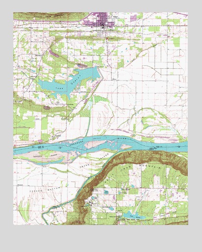
Atkins, AR USGS Topographic Map
Click on map above to begin viewing in our Map Viewer.

This topographic map contains these locations and features:
Feature Name Type Latitude Longitude GNIS ID View Map
Allens ChapelChurchN35.2031°W92.9468°76160View Map
AtkinsPopulated PlaceN35.2465°W92.9366°45966View Map
Atkins Catholic CemeteryCemeteryN35.2323°W92.9346°64918View Map
Atkins CemeteryCemeteryN35.2362°W92.9357°64919View Map
Atkins Elementary SchoolSchoolN35.2455°W92.9442°62114View Map
Atkins High SchoolSchoolN35.2453°W92.9419°62140View Map
Atkins Middle SchoolSchoolN35.2451°W92.9442°2039104View Map
Atkins Police DepartmentBuildingN35.2423°W92.9344°2118886View Map
Atkins Volunteer Fire DepartmentBuildingN35.2428°W92.9359°2116099View Map
Austin School (historical)SchoolN35.2351°W92.9079°62142View Map
Bells ChapelChurchN35.2126°W92.9843°46369View Map
Bells ChapelLocaleN35.2251°W92.9791°46370View Map
Bells Chapel CemeteryCemeteryN35.2223°W92.9866°46371View Map
Bells Chapel United Methodist ChurchChurchN35.2256°W92.9782°62136View Map
Byerly CemeteryCemeteryN35.1840°W92.8854°64921View Map
Carden BottomFlatN35.1437°W92.9916°47465View Map
Cedar CreekStreamN35.1334°W92.9738°47590View Map
Cedar Creek BridgeBridgeN35.1284°W92.9252°66180View Map
City of AtkinsCivilN35.2416°W92.9463°2403125View Map
Crane IslandFlatN35.1631°W92.9416°48141View Map
Darr CemeteryCemeteryN35.2231°W92.9860°48362View Map
Froneberger School (historical)SchoolN35.2326°W92.9849°62137View Map
Galla CreekStreamN35.1743°W92.9388°49312View Map
Galla RockPopulated PlaceN35.1779°W92.9696°57788View Map
Galla Rock Ferry (historical)CrossingN35.1731°W92.9488°70219View Map
Galla ShoalRapidsN35.1700°W92.9061°2784706View Map
Gally Rock CemeteryCemeteryN35.1756°W92.9716°64923View Map
Gold HillPopulated PlaceN35.1959°W92.9618°62134View Map
Gold Hill SchoolSchoolN35.1962°W92.9602°49475View Map
Horsehead BranchStreamN35.2090°W92.9827°50329View Map
Lake AbbyReservoirN35.1410°W92.9432°79863View Map
Lake Abby DamDamN35.1401°W92.9435°79862View Map
Lake AmandaReservoirN35.1461°W92.9226°70299View Map
Lake AtkinsReservoirN35.2090°W92.9596°79725View Map
Lake Atkins DamDamN35.2180°W92.9402°79724View Map
Lake BaileyReservoirN35.1301°W92.9252°79857View Map
Lake Bailey DamDamN35.1301°W92.9252°79856View Map
Lake ElsieReservoirN35.1369°W92.9471°70330View Map
Lake GeorgeReservoirN35.1439°W92.9243°70333View Map
Lake JeannetteReservoirN35.1347°W92.9299°79865View Map
Lake Jeannette DamDamN35.1351°W92.9302°79864View Map
Lake LucyReservoirN35.1443°W92.9336°79861View Map
Lake Lucy DamDamN35.1434°W92.9335°79860View Map
Libby Ferry (historical)CrossingN35.1368°W92.9657°66199View Map
Missionary ChurchChurchN35.1301°W92.9266°52099View Map
Norris ChapelChurchN35.1973°W92.9671°52799View Map
Petit Jean Fire StationBuildingN35.1367°W92.8914°2116954View Map
Petit Jean MountainRidgeN35.1601°W92.9260°53307View Map
Petit Jean Park AirportAirportN35.1454°W92.9058°83787View Map
Petit Jean RiverStreamN35.1695°W92.9074°81887View Map
Petit Jean Water Supply DamDamN35.1251°W92.9218°79858View Map
Pope County Emergency Medical Service Station 2BuildingN35.2425°W92.9347°2119142View Map
Roosevelt LakeReservoirN35.1306°W92.9143°70372View Map
Sweeden IslandBarN35.1654°W92.9771°55375View Map
Township of Cedar FallsCivilN35.1390°W92.9071°66437View Map
Township of Lee (historical)CivilN35.2029°W92.9002°70145View Map
Township of WilsonCivilN35.2180°W92.9340°69715View Map
Trinity Lutheran ChurchChurchN35.1329°W92.9252°78580View Map
Union Church (historical)ChurchN35.2256°W92.9896°62138View Map
Weathers School (historical)SchoolN35.2143°W92.9832°62135View Map
White Hall School (historical)SchoolN35.1484°W92.9979°81638View Map
WhitehallPopulated PlaceN35.1487°W92.9971°57235View Map
WilsonPopulated PlaceN35.2104°W92.9296°58898View Map
Wilson School (historical)SchoolN35.2026°W92.9121°62141View Map
WinrockPopulated PlaceN35.1381°W92.9438°58902View Map

Note: Coordinates in the location and feature list above are referenced to NAD83 datum.


Copyright (C) 2008-2024 Ryan Niemi / Sunset Dynamics ... All Rights Reserved