TopoQuest Logo
Do you find TopoQuest useful?
Help keep TopoQuest running and adding new maps/features by donating!
Bitcoin:  19c7KJd3qBynnjoSw5npx9KScwjBe4ifkT
Litecoin:  LXs6TkuXGGXo1vDsWCkWVdjQX94eUKd6ui
Home View Maps Find Maps Find Places Resources & Links


Holtwood, Pennsylvania Topographic Map

USGS Map Title: Holtwood, PA
USGS Map MRC: 39076G3
DRG (GeoTIFF) Download: o39076g3.tif


Neighboring USGS Topographic Map Quads:


  Safe Harbor, PA  
39076H4
 

  Conestoga, PA  
39076H3
 

  Quarryville, PA  
39076H2
 

  Airville, PA  
39076G4
 

  Holtwood, PA  
39076G3
 

  Wakefield, PA  
39076G2
 

  Fawn Grove, PA  
39076F4
 

  Delta, PA  
39076F3
 

  Conowingo Dam, MD  
39076F2


Map MRC Location:

N40°
W77°
N40°
W76°
H8 H7 H6 H5 H4 H3 H2 H1
G8 G7 G6 G5 G4 G3 G2 G1
F8 F7 F6 F5 F4 F3 F2 F1
E8 E7 E6 E5 E4 E3 E2 E1
D8 D7 D6 D5 D4 D3 D2 D1
C8 C7 C6 C5 C4 C3 C2 C1
B8 B7 B6 B5 B4 B3 B2 B1
A8 A7 A6 A5 A4 A3 A2 A1
N39°
W77°
N39°
W76°

Holtwood, PA USGS 1:24K Topographic Map Preview:
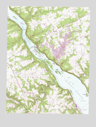
Holtwood, PA USGS Topographic Map
Click on map above to begin viewing in our Map Viewer.

This topographic map contains these locations and features:
Feature Name Type Latitude Longitude GNIS ID View Map
Anderson RunStreamN39.8148°W76.3286°1168287View Map
BeachIslandN39.7968°W76.2908°1168830View Map
BentonPopulated PlaceN39.7765°W76.2511°1203066View Map
BethesdaPopulated PlaceN39.8459°W76.3038°1203079View Map
Bethesda Post Office (historical)Post OfficeN39.8459°W76.3038°1214426View Map
Big Chestnut IslandIslandN39.7987°W76.2988°1169490View Map
Boeckel LandingPopulated PlaceN39.8018°W76.3113°1169930View Map
Bon ViewLocaleN39.8334°W76.3322°1212320View Map
Brubaker RunStreamN39.8682°W76.3636°1170422View Map
Brushy IslandIslandN39.8201°W76.3286°1170476View Map
Bryansville StationLocaleN39.7507°W76.3413°1170484View Map
Camp AndrewsLocaleN39.8398°W76.2533°1170972View Map
Camp MinquaLocaleN39.8604°W76.3719°1171056View Map
Castle FinPopulated PlaceN39.7684°W76.3283°1203231View Map
Castle Fin StationLocaleN39.7643°W76.3555°1171318View Map
Coal Cabin BeachLocaleN39.7815°W76.2930°1172048View Map
Counselman RunStreamN39.8545°W76.3602°1172501View Map
Coyne LockPopulated PlaceN39.7673°W76.2738°1203357View Map
CrowIslandN39.8120°W76.3180°1172773View Map
Crystal BrookStreamN39.8337°W76.3086°1172796View Map
Deepwater IslandIslandN39.8126°W76.3116°1173078View Map
DrumorePopulated PlaceN39.7918°W76.2650°1203449View Map
Drumore CemeteryCemeteryN39.8207°W76.2597°1173491View Map
Drumore Post OfficePost OfficeN39.8311°W76.2643°2779914View Map
DrytownPopulated PlaceN39.8609°W76.2925°1203453View Map
Duncan IslandIslandN39.8615°W76.3636°1173597View Map
Duncan RunStreamN39.8484°W76.3527°1173599View Map
Erbs MillPopulated PlaceN39.8629°W76.3377°1203525View Map
Face RockSummitN39.8140°W76.3066°1174400View Map
Face Rock OverlookLocaleN39.8334°W76.3322°1207024View Map
FernglenPopulated PlaceN39.8104°W76.2661°1203564View Map
Fishing CreekStreamN39.7609°W76.3522°1192465View Map
Fishing CreekStreamN39.7918°W76.2658°1174837View Map
ForsytheIslandN39.7920°W76.2819°1175004View Map
Hartman IslandIslandN39.8540°W76.3488°1176612View Map
Hennery IslandIslandN39.7979°W76.2950°1176837View Map
HoltwoodPopulated PlaceN39.8320°W76.3275°1177240View Map
Holtwood DamDamN39.8268°W76.3366°1192623View Map
House Rock RunStreamN39.8709°W76.3705°1177506View Map
Joy L Dairy FarmsLocaleN39.8197°W76.3528°2706891View Map
Kellys RunStreamN39.8348°W76.3388°1178341View Map
Kildary AcresLocaleN39.8214°W76.3706°2706892View Map
Lake AldredReservoirN39.8268°W76.3366°1192060View Map
Liberty SquareLocaleN39.8312°W76.2636°1179252View Map
Liberty Square Post Office (historical)Post OfficeN39.8312°W76.2636°1214427View Map
Little Chestnut IslandIslandN39.8012°W76.2997°1179502View Map
Lower Bear IslandIslandN39.8051°W76.3069°1180008View Map
Midway StationLocaleN39.7995°W76.2855°1181086View Map
Mount Johnson IslandIslandN39.7726°W76.2525°1217380View Map
Muddy CreekStreamN39.7901°W76.2994°1182043View Map
Muddy Creek ForksLocaleN39.7876°W76.3016°1182048View Map
Muddy RunStreamN39.8098°W76.3033°1182050View Map
Muddy Run Recreation DamDamN39.8434°W76.2780°1194375View Map
Muddy Run Recreation ReservoirReservoirN39.8449°W76.2788°1194376View Map
Neill RunStreamN39.7590°W76.3594°1182231View Map
Oakland RunStreamN39.8382°W76.3513°1182835View Map
Peach Bottom Power PlantBuildingN39.7584°W76.2663°1212754View Map
Peavine IslandIslandN39.8101°W76.3183°1193095View Map
Piney IslandIslandN39.8220°W76.3283°1183938View Map
Pinnacle OverlookLocaleN39.8457°W76.3447°1207025View Map
Rawlinsville ChurchChurchN39.8718°W76.2719°1184721View Map
Reed IslandIslandN39.8545°W76.3508°1184820View Map
Reed RunStreamN39.8645°W76.3580°1184821View Map
Robinson RunStreamN39.7770°W76.2786°1185230View Map
Rock Run DamDamN39.7584°W76.2663°1194352View Map
Ruff Field (historical)AirportN39.7543°W76.3511°1193731View Map
Salem ChurchChurchN39.7737°W76.3355°1186811View Map
Scott CreekStreamN39.7570°W76.3444°1193308View Map
SicilyIslandN39.7990°W76.2911°1187642View Map
SlabPopulated PlaceN39.7962°W76.3363°1204659View Map
State Game Lands Number 181ParkN39.8401°W76.3663°1208002View Map
SunnyburnPopulated PlaceN39.8057°W76.3708°1204774View Map
Susquehanna TrailsPopulated PlaceN39.7587°W76.3680°1867509View Map
Susquehanna Trails Census Designated PlaceCensusN39.7584°W76.3684°2390374View Map
Susquehannock OverlookLocaleN39.8034°W76.2897°1207028View Map
Susquehannock State ParkParkN39.8118°W76.2913°1196522View Map
Tobe RunStreamN39.8307°W76.3322°1189610View Map
Township of MarticCivilN39.8721°W76.3144°1216636View Map
Tucquan CreekStreamN39.8579°W76.3497°1189908View Map
Turkey IslandIslandN39.8079°W76.3027°1189940View Map
Union ChapelChurchN39.7959°W76.3552°1190122View Map
Upper Bear IslandIslandN39.8098°W76.3122°1190223View Map
Wallace RunStreamN39.8307°W76.3652°1190520View Map
WildcatIslandN39.8137°W76.3227°1191398View Map
Wissler RunStreamN39.8048°W76.2941°1191631View Map
WolfIslandN39.7993°W76.2975°1191647View Map

Note: Coordinates in the location and feature list above are referenced to NAD83 datum.


Copyright (C) 2008-2024 Ryan Niemi / Sunset Dynamics ... All Rights Reserved