TopoQuest Logo
Do you find TopoQuest useful?
Help keep TopoQuest running and adding new maps/features by donating!
Bitcoin:  19c7KJd3qBynnjoSw5npx9KScwjBe4ifkT
Litecoin:  LXs6TkuXGGXo1vDsWCkWVdjQX94eUKd6ui
Home View Maps Find Maps Find Places Resources & Links


Wakefield, Pennsylvania Topographic Map

USGS Map Title: Wakefield, PA
USGS Map MRC: 39076G2
DRG (GeoTIFF) Download: o39076g2.tif


Neighboring USGS Topographic Map Quads:


  Conestoga, PA  
39076H3
 

  Quarryville, PA  
39076H2
 

  Gap, PA  
39076H1
 

  Holtwood, PA  
39076G3
 

  Wakefield, PA  
39076G2
 

  Kirkwood, PA  
39076G1
 

  Delta, PA  
39076F3
 

  Conowingo Dam, MD  
39076F2
 

  Rising Sun, MD  
39076F1


Map MRC Location:

N40°
W77°
N40°
W76°
H8 H7 H6 H5 H4 H3 H2 H1
G8 G7 G6 G5 G4 G3 G2 G1
F8 F7 F6 F5 F4 F3 F2 F1
E8 E7 E6 E5 E4 E3 E2 E1
D8 D7 D6 D5 D4 D3 D2 D1
C8 C7 C6 C5 C4 C3 C2 C1
B8 B7 B6 B5 B4 B3 B2 B1
A8 A7 A6 A5 A4 A3 A2 A1
N39°
W77°
N39°
W76°

Wakefield, PA USGS 1:24K Topographic Map Preview:
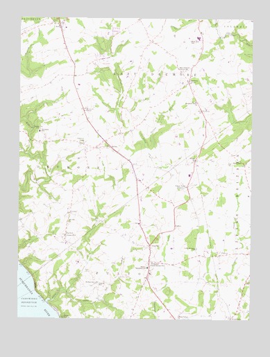
Wakefield, PA USGS Topographic Map
Click on map above to begin viewing in our Map Viewer.

This topographic map contains these locations and features:
Feature Name Type Latitude Longitude GNIS ID View Map
BethelPopulated PlaceN39.8159°W76.1547°1212307View Map
Bethel ChurchChurchN39.8159°W76.1555°1169372View Map
Brick Hill SchoolSchoolN39.8534°W76.1616°1170227View Map
BuckPopulated PlaceN39.8726°W76.2288°1203180View Map
Buck Post Office (historical)Post OfficeN39.8726°W76.2288°1214428View Map
Cherry HillSummitN39.7640°W76.2097°1171637View Map
Chestnut LevelPopulated PlaceN39.8229°W76.2158°1171735View Map
Chestnut Level Post Office (historical)Post OfficeN39.8229°W76.2158°1214434View Map
Clark Crest FarmLocaleN39.8661°W76.1622°2725550View Map
Country Meadows FarmsLocaleN39.8303°W76.1431°2725551View Map
Drumore CenterPopulated PlaceN39.8376°W76.2158°1203450View Map
East Drumore Central SchoolSchoolN39.8532°W76.1619°1173797View Map
EldoraPopulated PlaceN39.7912°W76.1841°1203502View Map
FairfiledPopulated PlaceN39.7848°W76.2244°1174428View Map
FairmountPopulated PlaceN39.8145°W76.1283°1203546View Map
Fulton HouseLocaleN39.8054°W76.1588°1175333View Map
Fulton House Post Office (historical)Post OfficeN39.8054°W76.1588°1214435View Map
Fulton Township SchoolSchoolN39.7715°W76.1802°1175340View Map
FurnissPopulated PlaceN39.7940°W76.2219°1203645View Map
GoshenPopulated PlaceN39.7879°W76.1655°1203701View Map
Goshen Post Office (historical)Post OfficeN39.7879°W76.1655°1214436View Map
Greene Post OfficePost OfficeN39.7848°W76.2244°1214694View Map
HenselPopulated PlaceN39.8218°W76.2008°1203784View Map
Hershberger FarmLocaleN39.8531°W76.1839°2725544View Map
Hopkins MillLocaleN39.8582°W76.2047°1212309View Map
Jackson RunStreamN39.8165°W76.1766°1177927View Map
Krantz Valley AcresLocaleN39.8369°W76.2033°2725546View Map
Little Britain Airport (historical)AirportN39.7906°W76.1404°1193738View Map
Little Britain ChurchChurchN39.7793°W76.1547°1179482View Map
Little Conowingo CreekStreamN39.7632°W76.1705°1179510View Map
McFarlands RunStreamN39.8293°W76.1891°1212308View Map
McSparranPopulated PlaceN39.7651°W76.2080°1204140View Map
Mechanic GrovePopulated PlaceN39.8487°W76.1586°1180841View Map
Mechanic Grove ChurchChurchN39.8404°W76.1547°1180842View Map
Mechanics Grove Post Office (historical)Post OfficeN39.8487°W76.1586°1214433View Map
Mid-Atlantic Region - 2-digit Hydrologic Unit Code - 02AreaN39.8084°W76.1660°2730132View Map
Mount Zion ChurchChurchN39.7904°W76.2227°1181909View Map
OakrynPopulated PlaceN39.7768°W76.1413°1204318View Map
Osceola SchoolSchoolN39.8290°W76.2386°1183068View Map
Peach BottomPopulated PlaceN39.7509°W76.2258°1183417View Map
Peach Bottom Post OfficePost OfficeN39.8021°W76.1862°2779790View Map
Peach Botton Post OfficePost OfficeN39.7737°W76.1791°1214704View Map
Penn HillPopulated PlaceN39.7807°W76.1788°1204377View Map
Peters CreekStreamN39.7579°W76.2322°1183623View Map
Puddle Duck CreekStreamN39.7612°W76.2236°1184483View Map
Robert Fulton Fire Company Station 89BuildingN39.7747°W76.1788°2100329View Map
Rohrer Airport (historical)AirportN39.8334°W76.1830°1193755View Map
Solanco High SchoolSchoolN39.8668°W76.1538°1211862View Map
Tanglewood Airport (historical)AirportN39.8501°W76.2150°1193759View Map
Tanglewood Manor Golf CourseLocaleN39.8562°W76.2041°1205617View Map
Township of DrumoreCivilN39.8136°W76.2486°1216619View Map
Township of East DrumoreCivilN39.8530°W76.1743°1216623View Map
Township of FultonCivilN39.7577°W76.1875°1216630View Map
Ulrich's Poultry FarmLocaleN39.8256°W76.1944°2725556View Map
UnicornPopulated PlaceN39.8368°W76.1519°1204848View Map
Valley M Pork FarmLocaleN39.8283°W76.1586°2725557View Map
WakefieldPopulated PlaceN39.7737°W76.1791°1190487View Map
Wakefield Ambulance Station 88BuildingN39.7744°W76.1793°2722197View Map
Wakefield Census Designated PlaceCensusN39.7766°W76.1803°2584523View Map
Wakefield Post Office (historical)Post OfficeN39.7737°W76.1791°1214442View Map
WrightsdalePopulated PlaceN39.7507°W76.1347°1204998View Map
Wrightsdale Post Office (historical)Post OfficeN39.7507°W76.1347°1214460View Map

Note: Coordinates in the location and feature list above are referenced to NAD83 datum.


Copyright (C) 2008-2024 Ryan Niemi / Sunset Dynamics ... All Rights Reserved