TopoQuest Logo
Do you find TopoQuest useful?
Help keep TopoQuest running and adding new maps/features by donating!
Bitcoin:  19c7KJd3qBynnjoSw5npx9KScwjBe4ifkT
Litecoin:  LXs6TkuXGGXo1vDsWCkWVdjQX94eUKd6ui
Home View Maps Find Maps Find Places Resources & Links


Hunter West, Arkansas Topographic Map

USGS Map Title: Hunter West, AR
USGS Map MRC: 35091A2
DRG (GeoTIFF) Download: o35091a2.tif


Neighboring USGS Topographic Map Quads:


  Gregory, AR  
35091B3
 

  Grays, AR  
35091B2
 

  Fair Oaks, AR  
35091B1
 

  Cotton Plant, AR  
35091A3
 

  Hunter West, AR  
35091A2
 

  Hunter East, AR  
35091A1
 

  De Valls Bluff NE, AR  
34091H3
 

  Brinkley, AR  
34091H2
 

  Wheatley, AR  
34091H1


Map MRC Location:

N36°
W92°
N36°
W91°
H8 H7 H6 H5 H4 H3 H2 H1
G8 G7 G6 G5 G4 G3 G2 G1
F8 F7 F6 F5 F4 F3 F2 F1
E8 E7 E6 E5 E4 E3 E2 E1
D8 D7 D6 D5 D4 D3 D2 D1
C8 C7 C6 C5 C4 C3 C2 C1
B8 B7 B6 B5 B4 B3 B2 B1
A8 A7 A6 A5 A4 A3 A2 A1
N35°
W92°
N35°
W91°

Hunter West, AR USGS 1:24K Topographic Map Preview:
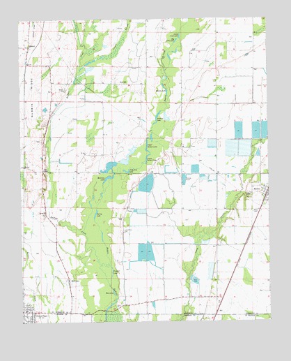
Hunter West, AR USGS Topographic Map
Click on map above to begin viewing in our Map Viewer.

This topographic map contains these locations and features:
Feature Name Type Latitude Longitude GNIS ID View Map
BectonPopulated PlaceN35.0643°W91.2485°56923View Map
Big York LakeLakeN35.1161°W91.1710°74673View Map
Blue LakeLakeN35.0125°W91.2039°74687View Map
Brushy LakeLakeN35.0948°W91.1757°74708View Map
Buffalo CreekStreamN35.0151°W91.2060°76460View Map
Buzzard LakeLakeN35.0205°W91.2045°74725View Map
CaseyPopulated PlaceN35.0462°W91.1973°57524View Map
Casey CemeteryCemeteryN35.0429°W91.1990°47513View Map
Cotton Plant Volunteer Fire DepartmentBuildingN35.0041°W91.2492°2116312View Map
Crowder CemeteryCemeteryN35.0447°W91.2389°60654View Map
Crowder ChurchChurchN35.0451°W91.2382°48231View Map
Four ForksPopulated PlaceN35.0623°W91.2390°57769View Map
Holly CemeteryCemeteryN35.1120°W91.1632°50211View Map
HowellPopulated PlaceN35.1137°W91.2454°77246View Map
Howell Post OfficePost OfficeN35.1140°W91.2448°84591View Map
HunterPopulated PlaceN35.0529°W91.1262°57960View Map
Hunter Post OfficePost OfficeN35.0523°W91.1266°84592View Map
Johnson LakeLakeN35.0848°W91.1806°74930View Map
Lake Grove CemeteryCemeteryN35.0379°W91.1987°77433View Map
Little York LakeLakeN35.1178°W91.1690°74981View Map
Locust SloughStreamN35.1040°W91.2196°51381View Map
Lower Seibert LakeLakeN35.0687°W91.1857°75009View Map
McGregorPopulated PlaceN35.0173°W91.2265°51846View Map
Morrison LakeLakeN35.0595°W91.2057°75035View Map
Mount Zion ChurchChurchN35.0698°W91.2173°52477View Map
Nubbin RidgeRidgeN35.0934°W91.2440°52855View Map
Oak Ridge Church (historical)ChurchN35.0473°W91.1960°60670View Map
Polly Ann LakeLakeN35.0620°W91.1969°75080View Map
Reneau CemeteryCemeteryN35.0962°W91.2273°78165View Map
Spivey LakeLakeN35.0448°W91.2124°75139View Map
Union Church (historical)ChurchN35.0604°W91.1873°60680View Map
Upper Seibert LakeLakeN35.0728°W91.1860°75195View Map

Note: Coordinates in the location and feature list above are referenced to NAD83 datum.


Copyright (C) 2008-2024 Ryan Niemi / Sunset Dynamics ... All Rights Reserved