TopoQuest Logo
Do you find TopoQuest useful?
Help keep TopoQuest running and adding new maps/features by donating!
Bitcoin:  19c7KJd3qBynnjoSw5npx9KScwjBe4ifkT
Litecoin:  LXs6TkuXGGXo1vDsWCkWVdjQX94eUKd6ui
Home View Maps Find Maps Find Places Resources & Links


Kernan, Louisiana Topographic Map

USGS Map Title: Kernan, LA
USGS Map MRC: 30093E3
DRG (GeoTIFF) Download: o30093e3.tif


Neighboring USGS Topographic Map Quads:


  Singer, LA  
30093F4
 

  Mach Branch, LA  
30093F3
 

  Redhead Branch, LA  
30093F2
 

  Oretta, LA  
30093E4
 

  Kernan, LA  
30093E3
 

  Longville, LA  
30093E2
 

  DeQuincy, LA  
30093D4
 

  Gordon, LA  
30093D3
 

  Gaytine, LA  
30093D2


Map MRC Location:

N31°
W94°
N31°
W93°
H8 H7 H6 H5 H4 H3 H2 H1
G8 G7 G6 G5 G4 G3 G2 G1
F8 F7 F6 F5 F4 F3 F2 F1
E8 E7 E6 E5 E4 E3 E2 E1
D8 D7 D6 D5 D4 D3 D2 D1
C8 C7 C6 C5 C4 C3 C2 C1
B8 B7 B6 B5 B4 B3 B2 B1
A8 A7 A6 A5 A4 A3 A2 A1
N30°
W94°
N30°
W93°

Kernan, LA USGS 1:24K Topographic Map Preview:
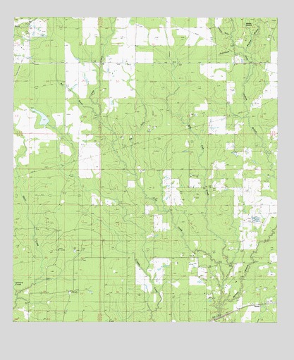
Kernan, LA USGS Topographic Map
Click on map above to begin viewing in our Map Viewer.

This topographic map contains these locations and features:
Feature Name Type Latitude Longitude GNIS ID View Map
Bear ChurchChurchN30.5249°W93.2532°532829View Map
Bear Oil FieldOilfieldN30.5188°W93.2860°553548View Map
Bear School (historical)SchoolN30.5080°W93.2621°544765View Map
Big GullyStreamN30.5602°W93.3174°533074View Map
Bull BayouStreamN30.5852°W93.3352°533524View Map
Cole CreekStreamN30.5041°W93.2782°554044View Map
Coleman GullyStreamN30.6166°W93.2729°534038View Map
Cowpen Creek Oil and Gas FieldOilfieldN30.5577°W93.2824°554112View Map
East Longville Oil FieldOilfieldN30.5755°W93.2696°534727View Map
Faith Baptist ChurchChurchN30.5080°W93.2619°2601614View Map
Four Corners Pentecostal ChurchChurchN30.5198°W93.2887°2602008View Map
Gordon Oil and Gas FieldOilfieldN30.5110°W93.3516°535293View Map
Greenhead GullyStreamN30.5944°W93.2663°535396View Map
Howard CreekStreamN30.5108°W93.3732°535835View Map
KernanPopulated PlaceN30.5071°W93.2624°554922View Map
Kernan Baptist ChurchChurchN30.5080°W93.2621°544764View Map
Longville ChurchChurchN30.5702°W93.2532°536722View Map
Longville Oil FieldOilfieldN30.5760°W93.3335°536723View Map
Louisiana Noname 75 DamDamN30.5819°W93.3568°556933View Map
Louisiana Noname 76 DamDamN30.5702°W93.2702°556934View Map
Mayhaw BranchStreamN30.5888°W93.2635°536951View Map
Middle BranchStreamN30.6185°W93.2629°537057View Map
Ragley Oil FieldOilfieldN30.5046°W93.2607°544767View Map
West Cowpen Creek Oil FieldOilfieldN30.5263°W93.3424°544763View Map
Wild Cow CreekStreamN30.5171°W93.2760°556418View Map

Note: Coordinates in the location and feature list above are referenced to NAD83 datum.


Copyright (C) 2008-2024 Ryan Niemi / Sunset Dynamics ... All Rights Reserved