TopoQuest Logo
Do you find TopoQuest useful?
Help keep TopoQuest running and adding new maps/features by donating!
Bitcoin:  19c7KJd3qBynnjoSw5npx9KScwjBe4ifkT
Litecoin:  LXs6TkuXGGXo1vDsWCkWVdjQX94eUKd6ui
Home View Maps Find Maps Find Places Resources & Links


Singer, Louisiana Topographic Map

USGS Map Title: Singer, LA
USGS Map MRC: 30093F4
DRG (GeoTIFF) Download: o30093f4.tif


Neighboring USGS Topographic Map Quads:


  Merryville North, LA  
30093G5
 

  Neale, LA  
30093G4
 

  DeRidder, LA  
30093G3
 

  Merryville South, LA  
30093F5
 

  Singer, LA  
30093F4
 

  Mach Branch, LA  
30093F3
 

  Fields, LA  
30093E5
 

  Oretta, LA  
30093E4
 

  Kernan, LA  
30093E3


Map MRC Location:

N31°
W94°
N31°
W93°
H8 H7 H6 H5 H4 H3 H2 H1
G8 G7 G6 G5 G4 G3 G2 G1
F8 F7 F6 F5 F4 F3 F2 F1
E8 E7 E6 E5 E4 E3 E2 E1
D8 D7 D6 D5 D4 D3 D2 D1
C8 C7 C6 C5 C4 C3 C2 C1
B8 B7 B6 B5 B4 B3 B2 B1
A8 A7 A6 A5 A4 A3 A2 A1
N30°
W94°
N30°
W93°

Singer, LA USGS 1:24K Topographic Map Preview:
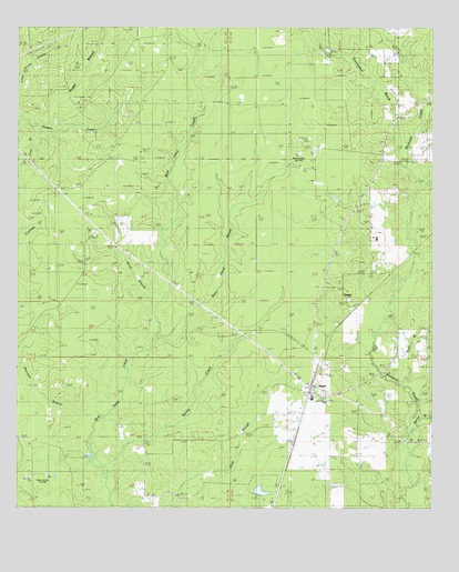
Singer, LA USGS Topographic Map
Click on map above to begin viewing in our Map Viewer.

This topographic map contains these locations and features:
Feature Name Type Latitude Longitude GNIS ID View Map
Bear Head MarshStreamN30.6699°W93.4579°553547View Map
Beauregard Parish Fire Protection District 1BuildingN30.6601°W93.4090°2691722View Map
Beauregard Parish Library Singer South Central BranchBuildingN30.6544°W93.4132°2603031View Map
Beckwith Baptist ChurchChurchN30.7280°W93.3832°553564View Map
Beehive Congregational Methodist ChurchChurchN30.6613°W93.3777°553575View Map
Black BranchStreamN30.6783°W93.4579°533175View Map
Black Branch Oil FieldOilfieldN30.6988°W93.4766°544799View Map
Boggy BranchStreamN30.7227°W93.4918°533295View Map
Buck BranchStreamN30.6585°W93.3879°533495View Map
Cowpen CreekStreamN30.7080°W93.3816°534220View Map
Crazy BranchStreamN30.7246°W93.4960°534235View Map
Holly Grove ChurchChurchN30.6774°W93.3996°535724View Map
Louisiana Noname 74 DamDamN30.7052°W93.4035°556932View Map
NewlinPopulated PlaceN30.6808°W93.4010°542008View Map
Newlin CemeteryCemeteryN30.6794°W93.4007°537664View Map
North Singer Oil FieldOilfieldN30.7160°W93.4160°542010View Map
Persimmon MarshStreamN30.7183°W93.3854°538081View Map
Raccoon BranchStreamN30.6430°W93.4791°538469View Map
SingerPopulated PlaceN30.6549°W93.4124°539395View Map
Singer Baptist ChurchChurchN30.6571°W93.4107°544802View Map
Singer Census Designated PlaceCensusN30.6512°W93.4117°2586709View Map
Singer High SchoolSchoolN30.6537°W93.4113°544800View Map
Singer Pentecostal ChurchChurchN30.6549°W93.4116°544801View Map
Singer Post OfficePost OfficeN30.6566°W93.4121°1630148View Map
Singer Volunteer Fire Department District 1BuildingN30.6558°W93.4127°2691776View Map
Spring BranchStreamN30.6499°W93.3802°539573View Map
Spring CreekStreamN30.6352°W93.4749°539582View Map
Ward FiveCivilN30.6333°W93.4196°544925View Map
West Juanita Oil FieldOilfieldN30.6321°W93.4927°542015View Map
Wildcat BranchStreamN30.6896°W93.3821°540402View Map
Zion ChurchChurchN30.7449°W93.4007°540594View Map

Note: Coordinates in the location and feature list above are referenced to NAD83 datum.


Copyright (C) 2008-2024 Ryan Niemi / Sunset Dynamics ... All Rights Reserved